Map of Pukalani CDP

Map of Pukalani CDP

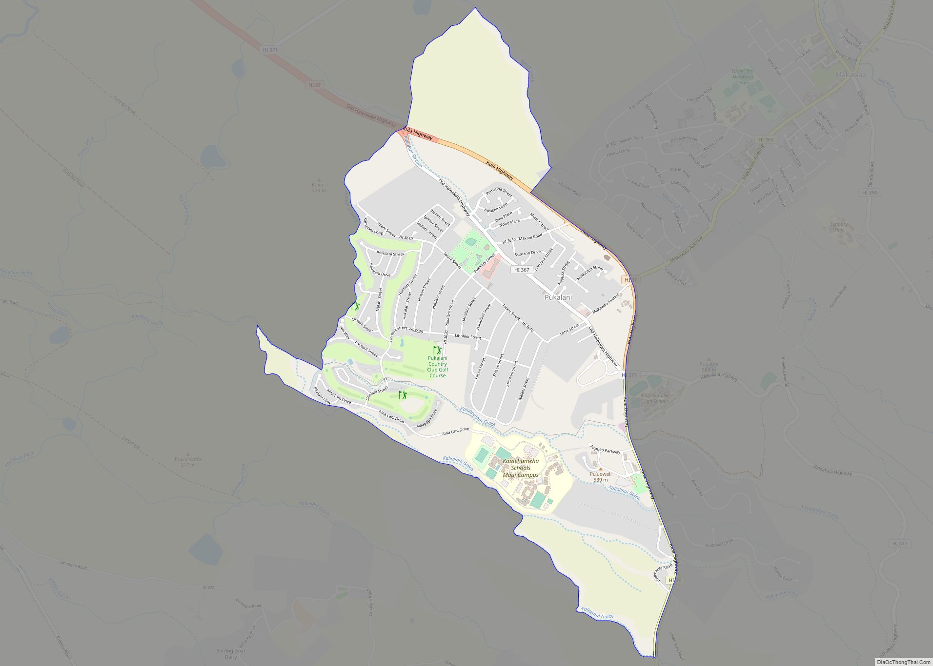
Pukalani is a census-designated place (CDP) in Maui County, Hawaiʻi, United States. The population was 8,299 at the 2020 census. The general volcano-slope region, including nearby Makawao and Kula, is referred to as upcountry by locals, and is one of the four major population centers on Maui, the other three being Kahului, Lahaina and Kīhei, … Read more

Map of Puhi CDP

Map of Puhi CDP

Puhi (literally, “blow” in Hawaiian) is a census-designated place (CDP) in Kauaʻi County, Hawaiʻi, United States. The population was 3,380 at the 2020 census, up from 1,186 at the 2000 census. Puhi CDP overview: Name: Puhi CDP LSAD Code: 57 LSAD Description: CDP (suffix) State: Hawaii County: Kauai County Elevation: 344 ft (105 m) Total Area: 0.89 sq mi … Read more

Map of Pupukea CDP

Map of Pupukea CDP

Pūpūkea (Hawaiian pronunciation: [puːpuːˈkɛjə]) is a community and census-designated place (CDP) in the Koʻolauloa District on the island of Oʻahu, City & County of Honolulu, Hawaii, United States. In Hawaiian, pūpūkea means “white shell”. As of the 2020 census, the CDP had a population of 5,130. The Koʻolauloa District ends at Waimea Bay, with the Waialua … Read more

Map of Schofield Barracks CDP

Map of Schofield Barracks CDP

Schofield Barracks is a United States Army installation and census-designated place (CDP) located in the City and County of Honolulu and in the Wahiawa District of the Hawaiian island of Oʻahu, Hawaiʻi. Schofield Barracks lies adjacent to the town of Wahiawā, separated from most of it by Lake Wilson (also known as Wahiawā Reservoir). Schofield … Read more

Map of Royal Kunia CDP

Map of Royal Kunia CDP

Royal Kunia is a census-designated place (CDP) on the island of Oʻahu in the City & County of Honolulu, Hawaiʻi, United States. As of the 2020 census,the population of the CDP was 14,896. The area was recorded as the Village Park CDP in prior censuses. Royal Kunia CDP overview: Name: Royal Kunia CDP LSAD Code: … Read more

Map of Wahiawa CDP

Map of Wahiawa CDP

Wahiawa (Hawaiian: Wahiawā, pronounced [wəhijəˈvaː]) is a census-designated place (CDP) in Honolulu County, Hawaii, United States, on the island of Oahu. It is in the Wahiawa District, on the plateau or “central valley” between the two volcanic mountains that bookend the island. In Hawaiian, wahi a wā means “place of the wa people”. The population was … Read more

Map of Volcano CDP, Hawaii

Map of Volcano CDP, Hawaii

Volcano is a census-designated place (CDP) in Hawaii County, Hawaii, United States located in the District of Puna with a small portion of the CDP in the District of Kaʻū. The population was 2,575 at the 2010 census, up from 2,231 at the 2000 census. Volcano CDP overview: Name: Volcano CDP LSAD Code: 57 LSAD … Read more

Map of Ualapue CDP

Map of Ualapue CDP

Ualapue CDP overview: Name: Ualapue CDP LSAD Code: 57 LSAD Description: CDP (suffix) State: Hawaii County: Maui County FIPS code: 1570700 Online Interactive Map Ualapue online map. Source: Basemap layers from Google Map, Open Street Map (OSM), Arcgisonline, Wmflabs. Boundary Data from Database of Global Administrative Areas. Ualapue location map. Where is Ualapue CDP? Ualapue … Read more

Map of Waihee-Waiehu CDP

Map of Waihee-Waiehu CDP

Waihee-Waiehu (Hawaiian: Waiheʻe-Waiehu) is a census-designated place (CDP) in Maui County, Hawaii, United States. The population was 9,234 at the 2020 census. Waihee-Waiehu CDP overview: Name: Waihee-Waiehu CDP LSAD Code: 57 LSAD Description: CDP (suffix) State: Hawaii County: Maui County Total Area: 5.12 sq mi (13.27 km²) Land Area: 4.26 sq mi (11.04 km²) Water Area: 0.86 sq mi (2.22 km²) Total Population: 9,234 … Read more

Map of Waianae CDP

Map of Waianae CDP

Waiʻanae (Hawaiian pronunciation: [vɐjʔəˈnɐe̯]) is a census-designated place (CDP) in Honolulu County, Hawaii, United States. As of the 2020 census, the CDP population was 13,614. Its name means “waters of the mullet”. Its etymology is shared with the far northern Wellington suburb of Waikanae, located in New Zealand. Waianae CDP overview: Name: Waianae CDP LSAD Code: … Read more

Map of Waialua CDP

Map of Waialua CDP

Waialua (Hawaiian pronunciation: [vɐjəˈluwə]) is a census-designated place and North Shore community in the Waialua District on the island of Oʻahu, City & County of Honolulu, Hawaii, United States. As of the 2020 census, the CDP had a population of 4,062. Waialua was one of the six original districts of ancient Hawaii on the island, known … Read more

Map of Waikele CDP

Map of Waikele CDP

Waikele (Hawaiian pronunciation: [vɐjˈkɛlɛ]) is a census-designated place (CDP) in Honolulu County, Hawaii, United States. As of the 2020 census, the CDP population was 7,509. Residents use Waipahu, Hawaii for their postal city. Waikele CDP overview: Name: Waikele CDP LSAD Code: 57 LSAD Description: CDP (suffix) State: Hawaii County: Honolulu County Elevation: 220 ft (70 m) Total Area: … Read more