Map of Waikapu CDP

Map of Waikapu CDP

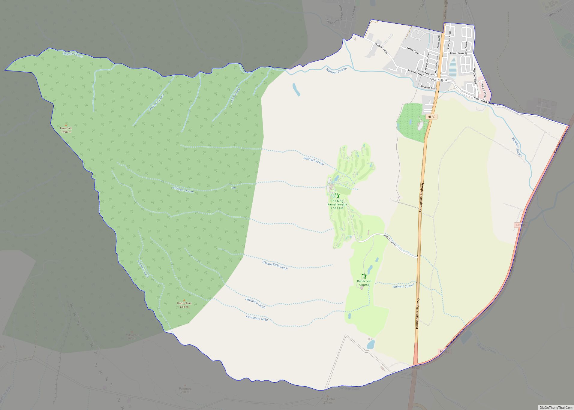
Waikapu (Hawaiian: Waikapū) is a census-designated place (CDP) in Maui County, Hawaii, United States. The population was 3,437 at the 2020 census. Waikapu CDP overview: Name: Waikapu CDP LSAD Code: 57 LSAD Description: CDP (suffix) State: Hawaii County: Maui County Elevation: 482 ft (147 m) Total Area: 11.04 sq mi (28.59 km²) Land Area: 11.02 sq mi (28.54 km²) Water Area: 0.02 sq mi (0.05 km²) … Read more

Map of Waikane CDP

Map of Waikane CDP

Waikāne or Waikane (Hawaiian pronunciation: [vɐjˈkaːne]), also known as North Koʻolaupoko ([-koʔolɐwˈpoko]), is an area and census-designated place in the County of Honolulu, Hawaii, United States, on the island of Oʻahu. It had a population of 778 at the 2010 census. In Hawaiian, koʻolau poko means “short windward”, referring to the fact that this is the … Read more

Map of Wailua Homesteads CDP

Map of Wailua Homesteads CDP

Wailua Homesteads is a census-designated place (CDP) in Kauaʻi County, Hawaiʻi, United States. The population was 5,863 at the 2020 census, up from 4,567 at the 2000 census. Wailua Homesteads CDP overview: Name: Wailua Homesteads CDP LSAD Code: 57 LSAD Description: CDP (suffix) State: Hawaii County: Kauai County Elevation: 360 ft (110 m) Total Area: 7.41 sq mi (19.19 km²) … Read more

Map of Wailea CDP

Map of Wailea CDP

Wailea is a census-designated place (CDP) in Maui County, Hawaii, United States. As of the 2020 census, it had a population of 6,027. Prior to 2010, the area was part of the Wailea-Makena census-designated place. The community was developed in 1971 by a partnership of Alexander & Baldwin and Northwestern Mutual. Wailea CDP overview: Name: … Read more

Map of Waikoloa Village CDP

Map of Waikoloa Village CDP

Waikōloa Village is a census-designated place (CDP) in Hawaiʻi County, Hawaii, United States. The population was 6,362 at the 2010 census, up from 4,806 at the 2000 census. The name Waikoloa is used by the local post office. Waikoloa Village CDP overview: Name: Waikoloa Village CDP LSAD Code: 57 LSAD Description: CDP (suffix) State: Hawaii … Read more

Map of Waimalu CDP

Map of Waimalu CDP

Waimalu (Hawaiian pronunciation: [vɐjˈmɐlu]) is a census-designated place (CDP) in Honolulu County, Hawaiʻi, United States. The population was 13,817 at the 2020 census. Waimalu CDP overview: Name: Waimalu CDP LSAD Code: 57 LSAD Description: CDP (suffix) State: Hawaii County: Honolulu County Elevation: 377 ft (115 m) Total Area: 1.92 sq mi (4.97 km²) Land Area: 1.83 sq mi (4.74 km²) Water Area: 0.09 sq mi (0.23 km²) … Read more

Map of Wailuku CDP

Map of Wailuku CDP

Wailuku CDP overview: Name: Wailuku CDP LSAD Code: 57 LSAD Description: CDP (suffix) State: Hawaii County: Maui County FIPS code: 1577450 Online Interactive Map Wailuku online map. Source: Basemap layers from Google Map, Open Street Map (OSM), Arcgisonline, Wmflabs. Boundary Data from Database of Global Administrative Areas. Wailuku location map. Where is Wailuku CDP? Wailuku … Read more

Map of Wailua CDP

Map of Wailua CDP

Wailua (literally, “two waters” in Hawaiian) is a census-designated place (CDP) in Kauaʻi County, Hawaiʻi, United States. The population was 2,359 at the 2020 census, up from 2,083 at the 2000 census. Wailua CDP overview: Name: Wailua CDP LSAD Code: 57 LSAD Description: CDP (suffix) State: Hawaii County: Kauai County Elevation: 20 ft (6 m) Total Area: … Read more

Map of Waimea CDP

Map of Waimea CDP

Waimea (literally, “red water” in Hawaiian) is a census-designated place (CDP) in Kauaʻi County, Hawaiʻi, United States. The population was 2,057 at the 2020 census. The first Europeans to reach Hawaii landed in Waimea in 1778 (giving rise to Kauai’s cheeky slogan: “Hawaii’s Original Visitor Destination”). Waimea CDP overview: Name: Waimea CDP LSAD Code: 57 … Read more

Map of Waimanalo CDP

Map of Waimanalo CDP

Waimānalo (Hawaiian pronunciation: [vɐjmaːˈnɐlo]) is a census-designated place (CDP) in the City & County of Honolulu, in the District of Koʻolaupoko on the island of Oʻahu, Hawaii, United States. This small windward community is located near the eastern end of the island. In the Hawaiian language Waimānalo means “potable water”; it is so named for the … Read more

Map of Waimanalo Beach CDP

Map of Waimanalo Beach CDP

Waimānalo Beach is a census-designated place (CDP) located in the City & County of Honolulu, in the District of Koʻolaupoko, on the island of Oʻahu in the U.S. state of Hawaiʻi. This small windward community is located near the eastern end of the island, and the climate is dry. As of the 2020 census, the … Read more

Map of Waiohinu CDP

Map of Waiohinu CDP

Waiʻōhinu (Hawaiian: Waiʻōhinu; translation: “Shiny Water”) is an unincorporated community and census-designated place (CDP) in the district of Kaʻu on the Big Island of Hawaiʻi, in the U.S. state of Hawaiʻi. Waiʻōhinu is the name of the community as well as the ahupua’a, Native Hawaiian subdivision. As of the 2020 census, the CDP had a … Read more