Map of Maalaea CDP

Map of Maalaea CDP

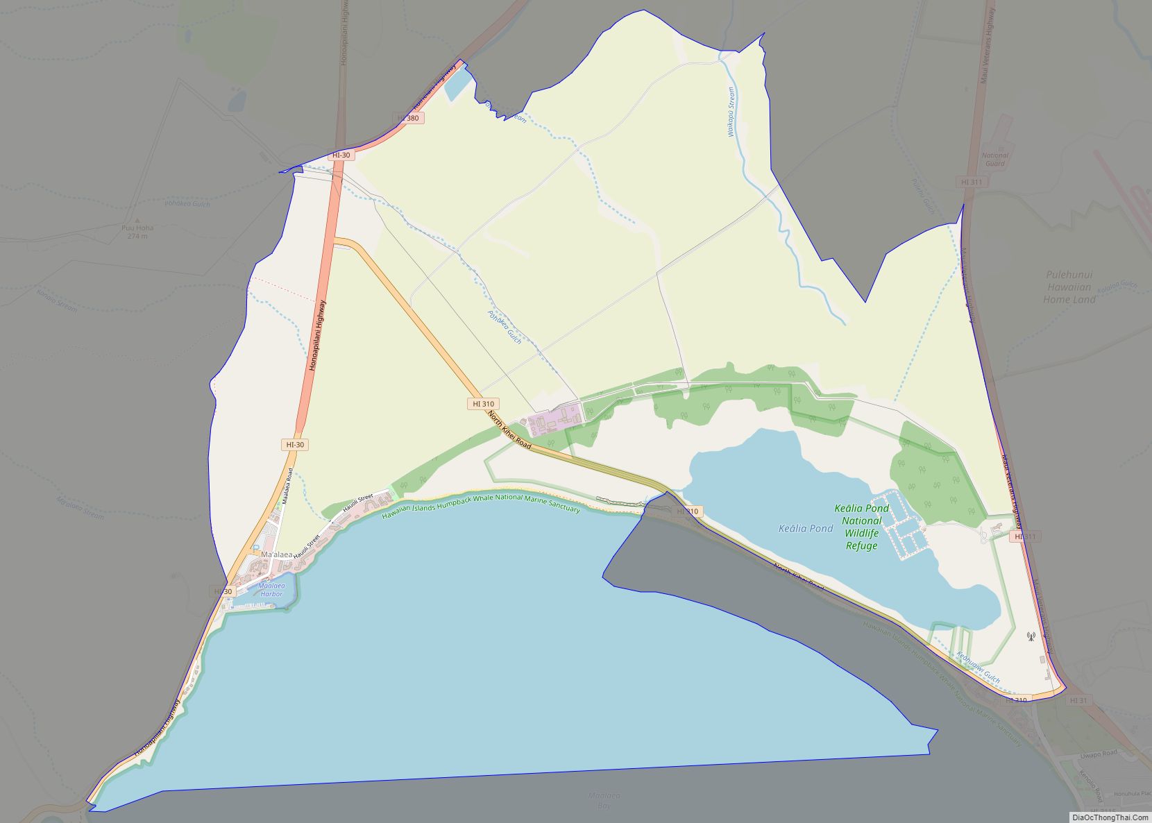
Maalaea (Hawaiian: Māʻalaea) is a census-designated place (CDP) in Maui County, Hawaii, United States. The population was 310 at the 2020 census. Maalaea is the site of a small boat harbor, as well as the Maui Ocean Center, and a Shinto shrine, as well as being the historical location for the original Maui Airport. Maalaea … Read more

Map of Lihue CDP

Map of Lihue CDP

Lihue CDP overview: Name: Lihue CDP LSAD Code: 57 LSAD Description: CDP (suffix) State: Hawaii County: Kauai County FIPS code: 1545200 Online Interactive Map Lihue online map. Source: Basemap layers from Google Map, Open Street Map (OSM), Arcgisonline, Wmflabs. Boundary Data from Database of Global Administrative Areas. Lihue location map. Where is Lihue CDP? Lihue … Read more

Map of Makaha CDP

Map of Makaha CDP

Mākaha (Hawaiian for “fierce”, or “savage”, pronounced [maːˈkɐhə]) is a census-designated place (CDP) in Honolulu County, Hawaiʻi, United States. It is a town located along the Pacific coast, west of the Mākaha Valley, and at the foot of Mt. Ka’ala in the Wai’anae Mountain Range. It is the last of the leeward towns on O’ahu. North … Read more

Map of Makaha Valley CDP

Map of Makaha Valley CDP

Mākaha Valley is a census-designated place (CDP) in Honolulu County, Hawaiʻi, United States. The population was 198 at the 2020 census. Makaha Valley CDP overview: Name: Makaha Valley CDP LSAD Code: 57 LSAD Description: CDP (suffix) State: Hawaii County: Honolulu County Elevation: 285 ft (87 m) Total Area: 3.74 sq mi (9.68 km²) Land Area: 3.74 sq mi (9.68 km²) Water Area: 0.00 sq mi … Read more

Map of Maili CDP

Map of Maili CDP

Māʻili (Hawaiian pronunciation: [maːˈʔili]) is a census-designated place (CDP) in the Waiʻanae District on the island of Oʻahu, City & County of Honolulu, Hawaiʻi, United States. In Hawaiian, māʻili means “pebbly”, referring to rounded stones at the shore. Māʻili is located along Farrington Highway on Oʻahu’s Leeward Coast, between Māʻili Beach Park to the west and … Read more

Map of Makena CDP

Map of Makena CDP

Makena is a census-designated place (CDP) in Maui County, Hawaiʻi, United States. As of the 2020 census, it had a population of 196, up from 99 in 2010. Prior to 2010, the area was part of the Wailea-Makena census-designated place. Makena CDP overview: Name: Makena CDP LSAD Code: 57 LSAD Description: CDP (suffix) State: Hawaii … Read more

Map of Makawao CDP

Map of Makawao CDP

Makawao is a census-designated place (CDP) in Maui County, Hawaiʻi, United States. The population was 7,297 at the 2020 census. Located on the rural northwest slope of Haleakala on East Maui, the community is known for being the hub of the “Upcountry”, a part of the island dominated by mostly agriculture and ranch land. Makawao … Read more

Map of Makakilo CDP

Map of Makakilo CDP

Makakilo (Hawaiian pronunciation: [məkəˈtilo]) or Makakilo City is a census-designated place and residential area located in the ʻEwa District on the island of Oʻahu in the City & County of Honolulu, United States. In Hawaiian, maka kilo means “observing eyes”. As of the 2020 census, the CDP had a population of 19,877. Makakilo CDP overview: Name: … Read more

Map of Maunawili CDP

Map of Maunawili CDP

Maunawili (Hawaiian pronunciation: [mɐwnəˈvili]) is a residential census-designated place (CDP) in the City & County of Honolulu, Koʻolaupoko District, Island of Oʻahu, Hawaii, United States. As of the 2020 census, the CDP had a population of 2,026. Situated mauka (inland or mountain side) of Kalanianaʻole Highway between Castle Junction and Castle Hospital, Maunawili is nearly all … Read more

Map of Maunaloa CDP

Map of Maunaloa CDP

Maunaloa (Hawaiian pronunciation: [mɐwnəˈlowə]) or Mauna Loa is a census-designated place (CDP) in Maui County, Hawaiʻi, United States, in the western part of the island of Molokai. The population was 435 at the 2020 census. Maunaloa CDP overview: Name: Maunaloa CDP LSAD Code: 57 LSAD Description: CDP (suffix) State: Hawaii County: Maui County Elevation: 889 ft (271 m) … Read more

Map of Manele CDP

Map of Manele CDP

Manele is a census-designated place (CDP) in Maui County, Hawaii, United States, on the island of Lanai. As of the 2020 census, the CDP had a population of 7. Manele is one of only two census-designated places on Lanai, the other being the much larger Lanai City. Manele is the site of Four Seasons Resort … Read more

Map of Mokuleia CDP

Map of Mokuleia CDP

Mokulēʻia (Hawaiian pronunciation: [mokuleːˈʔijə]) is a North Shore community and census-designated place (CDP) in the Waialua District on the island of Oʻahu, City & County of Honolulu, Hawaiʻi, United States. Mokulēʻia means “isle [of] abundance” in Hawaiian. As of the 2020 census, the CDP had a population of 1,816. Features of interest here include Mokulēʻia Beach, … Read more