Map of New Seabury CDP

Map of New Seabury CDP

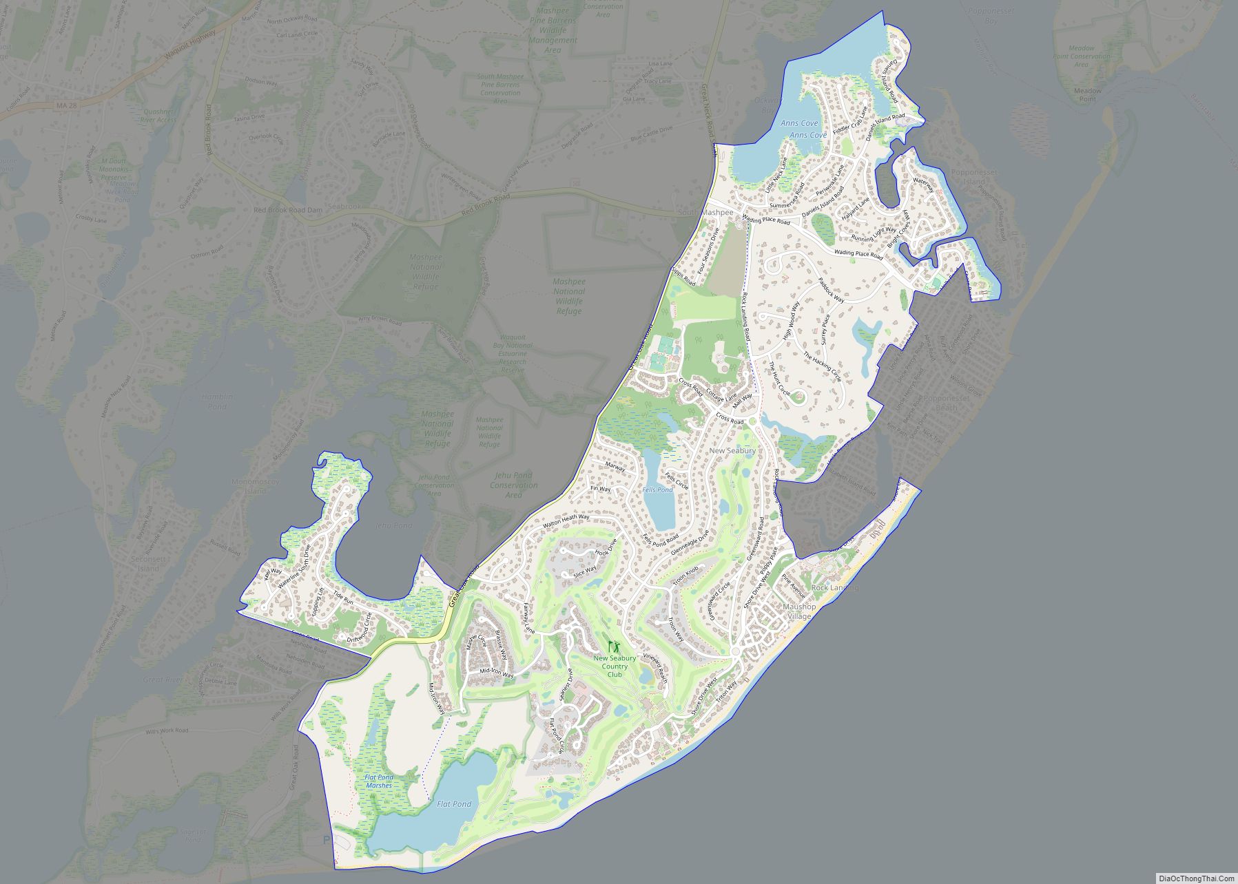
New Seabury is a census-designated place (CDP) in the town of Mashpee in Barnstable County, Massachusetts, United States, on Cape Cod. The area consists primarily of summer homes for wealthy families. Attractions include a county club and the Fells Pond, Daniels Island, and Littleneck Bay neighborhoods. The population of the CDP was 717 at the … Read more

Map of New Bedford city, Massachusetts

Map of New Bedford city, Massachusetts

New Bedford (Massachusett: Accushnet) is a city in Bristol County, Massachusetts, United States. It is located on the Acushnet River in what is known as the South Coast region. Up through the 17th century, the area was the territory of the Wampanoag Native American people. English colonists bought the land on which New Bedford would … Read more

Map of North Amherst CDP

Map of North Amherst CDP

North Amherst CDP overview: Name: North Amherst CDP LSAD Code: 57 LSAD Description: CDP (suffix) State: Massachusetts County: Hampshire County FIPS code: 2546295 Online Interactive Map North Amherst online map. Source: Basemap layers from Google Map, Open Street Map (OSM), Arcgisonline, Wmflabs. Boundary Data from Database of Global Administrative Areas. North Amherst location map. Where … Read more

Map of North Adams city

Map of North Adams city, Massachusetts

North Adams is a city in Berkshire County, Massachusetts, United States. It is part of the Pittsfield, Massachusetts Metropolitan Statistical Area. Its population was 12,961 as of the 2020 census. Best known as the home of the largest contemporary art museum in the United States, the Massachusetts Museum of Contemporary Art, North Adams has in … Read more

Map of Newton city, Massachusetts

Map of Newton city, Massachusetts

Newton is a city in Middlesex County, Massachusetts, United States. It is approximately 7 miles (11 km) west of downtown Boston. Newton resembles a patchwork of thirteen villages, without a city center. At the 2020 U.S. census, the population of Newton was 88,923. Newton city overview: Name: Newton city LSAD Code: 25 LSAD Description: city (suffix) … Read more

Map of North Falmouth CDP

Map of North Falmouth CDP

North Falmouth is a census-designated place (CDP) in the town of Falmouth in Barnstable County, Massachusetts, United States. The population was 3,084 at the 2010 census. North Falmouth CDP overview: Name: North Falmouth CDP LSAD Code: 57 LSAD Description: CDP (suffix) State: Massachusetts County: Barnstable County Elevation: 43 ft (13 m) Total Area: 6.62 sq mi (17.13 km²) Land Area: … Read more

Map of North Eastham CDP

Map of North Eastham CDP

North Eastham is a census-designated place (CDP) in the town of Eastham in Barnstable County, Massachusetts, United States. The population was 1,806 at the 2010 census. The main visitor center of the Cape Cod National Seashore is located in North Eastham. North Eastham CDP overview: Name: North Eastham CDP LSAD Code: 57 LSAD Description: CDP … Read more

Map of North Brookfield CDP

Map of North Brookfield CDP

North Brookfield is a census-designated place (CDP) in the town of North Brookfield in Worcester County, Massachusetts, United States. The population was 2,265 at the 2010 census. North Brookfield CDP overview: Name: North Brookfield CDP LSAD Code: 57 LSAD Description: CDP (suffix) State: Massachusetts County: Worcester County Elevation: 873 ft (266 m) Total Area: 1.48 sq mi (3.82 km²) Land … Read more

Map of North Plymouth CDP

Map of North Plymouth CDP

North Plymouth CDP overview: Name: North Plymouth CDP LSAD Code: 57 LSAD Description: CDP (suffix) State: Massachusetts County: Plymouth County FIPS code: 2548780 Online Interactive Map North Plymouth online map. Source: Basemap layers from Google Map, Open Street Map (OSM), Arcgisonline, Wmflabs. Boundary Data from Database of Global Administrative Areas. North Plymouth location map. Where … Read more

Map of North Pembroke CDP

Map of North Pembroke CDP

North Pembroke is a census-designated place (CDP) in the town of Pembroke in Plymouth County, Massachusetts, United States. The population was 3,292 at the 2010 census. North Pembroke CDP overview: Name: North Pembroke CDP LSAD Code: 57 LSAD Description: CDP (suffix) State: Massachusetts County: Plymouth County Elevation: 46 ft (14 m) Total Area: 4.48 sq mi (11.59 km²) Land Area: … Read more

Map of North Lakeville CDP

Map of North Lakeville CDP

North Lakeville is a census-designated place (CDP) in the town of Lakeville in Plymouth County, Massachusetts, United States. The population was 2,630 at the 2010 census. It is roughly bounded by the Middleboro-Lakeville town line to the east, Assawompset Pond to the south, Precinct Street to the southwest, and Rhode Island Road (Route 79) to … Read more

Map of North Westport CDP

Map of North Westport CDP

North Westport is a census-designated place (CDP) in the town of Westport in Bristol County, Massachusetts, United States. The population was 4,571 at the 2010 census. North Westport CDP overview: Name: North Westport CDP LSAD Code: 57 LSAD Description: CDP (suffix) State: Massachusetts County: Bristol County Elevation: 138 ft (42 m) Total Area: 6.18 sq mi (16.00 km²) Land Area: … Read more