Map of Nenahnezad CDP

Map of Nenahnezad CDP

Nenahnezad (Navajo: Niinahnízaad) is a census-designated place (CDP) in San Juan County, New Mexico, United States. The population was 726 at the 2000 census. Nenahnezad is a Chapter community just to the south of Fruitland, between the towns of Farmington and Shiprock. It is part of the Farmington Metropolitan Statistical Area. Nenahnezad CDP overview: Name: … Read more

Map of Navajo CDP

Map of Navajo CDP

Navajo (Navajo: Niʼiijíhí) is a census-designated place (CDP) on the Navajo Nation in McKinley County, New Mexico, United States. The population was 2,097 at the 2000 census. Navajo is the most Navajo town in the United States, with 95.04% of residents having full or partial Navajo ancestry. Navajo CDP overview: Name: Navajo CDP LSAD Code: … Read more

Map of Navajo Dam CDP

Map of Navajo Dam CDP

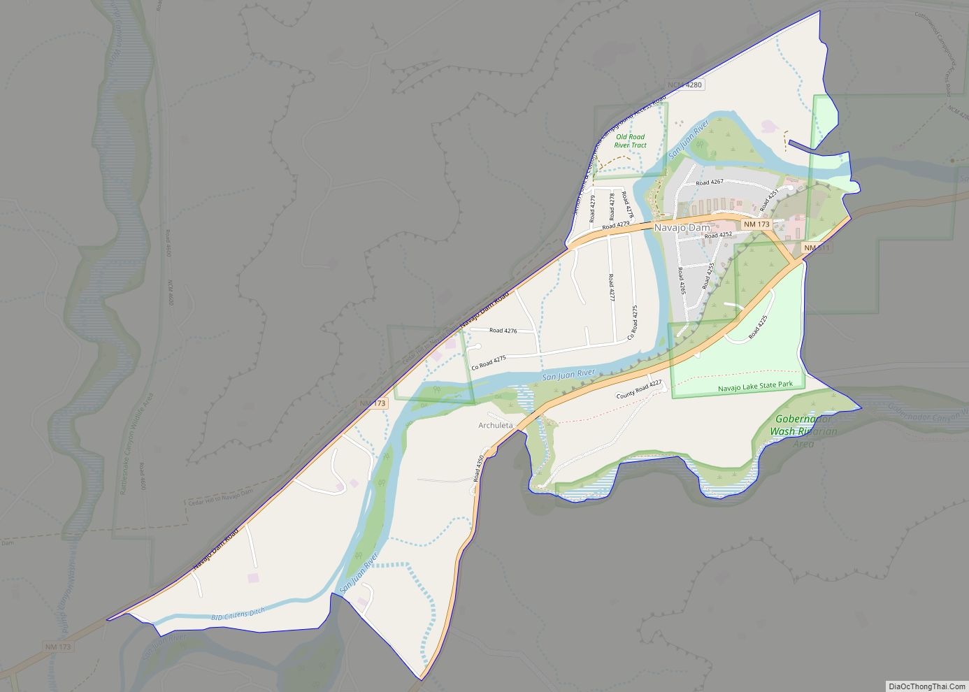
Navajo Dam is a census-designated place in San Juan County, New Mexico, United States. Its population was 253 as of the 2020 census. Navajo Dam has a post office with ZIP code 87419. The community is located in the vicinity of Navajo Dam. Navajo Dam CDP overview: Name: Navajo Dam CDP LSAD Code: 57 LSAD … Read more

Map of Naschitti CDP

Map of Naschitti CDP

Naschitti (Navajo: Nahashchʼidí) is a census-designated place (CDP) in San Juan County, New Mexico, United States. The population was 360 at the 2000 census. It is part of the Farmington Metropolitan Statistical Area. The town was established in 1886, when Tom Bryan set up a trading post east of the Chuska Mountains. With a Navajo … Read more

Map of Ojo Amarillo CDP

Map of Ojo Amarillo CDP

Ojo Amarillo is a census-designated place (CDP) in San Juan County, New Mexico, United States. The population was 829 at the 2000 census. It is part of the Farmington Metropolitan Statistical Area. Ojo Amarillo CDP overview: Name: Ojo Amarillo CDP LSAD Code: 57 LSAD Description: CDP (suffix) State: New Mexico County: San Juan County Elevation: … Read more

Map of Ohkay Owingeh CDP

Map of Ohkay Owingeh CDP

Ohkay Owingeh (Tewa: Ohkwee Ówîngeh [ʔòhkèː ʔówĩ̂ŋgè]), known by its Spanish name as San Juan de los Caballeros from 1589 to 2005, is a pueblo and census-designated place (CDP) in Rio Arriba County, New Mexico. Ohkay Owingeh is also a federally recognized tribe of Pueblo people inhabiting the town. Ohkay Owingeh CDP overview: Name: Ohkay … Read more

Map of Oasis CDP, New Mexico

Map of Oasis CDP, New Mexico

Oasis is a census-designated place in Sierra County, New Mexico, United States. Its population was 149 as of the 2010 census. Oasis CDP overview: Name: Oasis CDP LSAD Code: 57 LSAD Description: CDP (suffix) State: New Mexico County: Sierra County Elevation: 4,258 ft (1,298 m) Total Area: 2.09 sq mi (5.41 km²) Land Area: 2.09 sq mi (5.41 km²) Water Area: 0.00 sq mi (0.00 km²) … Read more

Map of North Valley CDP

Map of North Valley CDP

North Valley is a census-designated place (CDP) in Bernalillo County, New Mexico, United States. As of the 2010 Census, the CDP population was 11,333. It is part of the Albuquerque Metropolitan Statistical Area. North Valley CDP overview: Name: North Valley CDP LSAD Code: 57 LSAD Description: CDP (suffix) State: New Mexico County: Bernalillo County Elevation: … Read more

Map of North San Ysidro CDP

Map of North San Ysidro CDP

North San Ysidro is an unincorporated community and census-designated place in San Miguel County, New Mexico, United States. Its population was 159 as of the 2010 census. North San Ysidro CDP overview: Name: North San Ysidro CDP LSAD Code: 57 LSAD Description: CDP (suffix) State: New Mexico County: San Miguel County Elevation: 6,522 ft (1,988 m) Total … Read more

Map of North Light Plant CDP

Map of North Light Plant CDP

North Light Plant is an unincorporated community and census-designated place in San Juan County, New Mexico, United States. Its population was 414 as of the 2010 census. New Mexico State Road 574 passes through the community. North Light Plant CDP overview: Name: North Light Plant CDP LSAD Code: 57 LSAD Description: CDP (suffix) State: New … Read more

Map of North Hurley CDP

Map of North Hurley CDP

North Hurley is a census-designated place in Grant County, New Mexico, United States. Its population was 300 as of the 2010 census. The community is located north of Hurley along U.S. Route 180. North Hurley CDP overview: Name: North Hurley CDP LSAD Code: 57 LSAD Description: CDP (suffix) State: New Mexico County: Grant County Elevation: … Read more

Map of North Hobbs CDP

Map of North Hobbs CDP

North Hobbs is an unincorporated community and census-designated place in Lea County, New Mexico, United States. Its population was 5,391 as of the 2010 census. North Hobbs CDP overview: Name: North Hobbs CDP LSAD Code: 57 LSAD Description: CDP (suffix) State: New Mexico County: Lea County Elevation: 3,648 ft (1,112 m) Total Area: 26.08 sq mi (67.55 km²) Land Area: … Read more