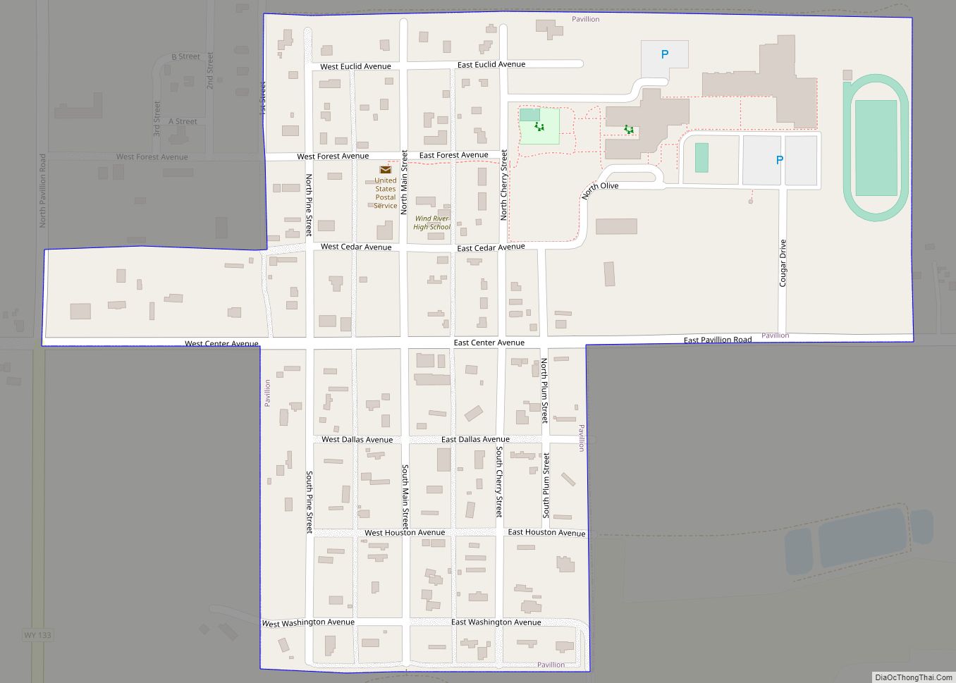
Map of Westview Circle CDP

Map of Westview Circle CDP

Westview Circle is a census-designated place (CDP) in Platte County, Wyoming, United States. The population was 52 at the 2010 census. Westview Circle CDP overview: Name: Westview Circle CDP LSAD Code: 57 LSAD Description: CDP (suffix) State: Wyoming County: Platte County Elevation: 4,731 ft (1,442 m) Total Area: 2.3 sq mi (6.0 km²) Land Area: 2.3 sq mi (5.9 km²) Water Area: 0.0 sq mi … Read more

Map of Y-O Ranch CDP

Map of Y-O Ranch CDP

Y-O Ranch is a census-designated place (CDP) in Platte County, Wyoming, United States. The population was 195 at the 2010 census. Y-O Ranch CDP overview: Name: Y-O Ranch CDP LSAD Code: 57 LSAD Description: CDP (suffix) State: Wyoming County: Platte County Elevation: 4,885 ft (1,489 m) Total Area: 2.4 sq mi (6.3 km²) Land Area: 2.4 sq mi (6.3 km²) Water Area: 0.0 sq mi … Read more

Map of Louisville/Jefferson County metro government (balance), Kentucky

Map of Louisville/Jefferson County metro government (balance), Kentucky

Louisville/Jefferson County metro government (balance) overview: Name: Louisville/Jefferson County metro government (balance) LSAD Code: 00 LSAD Description: metro government State: Kentucky County: Jefferson County Elevation: 466 ft (142 m) Land Area: 324.94 sq mi (841.59 km²) Water Area: 16.50 sq mi (42.73 km²) Population Density: 1,900/sq mi (720/km²) Area code: 502 FIPS code: 2148006 GNISfeature ID: 0509453 Website: louisvilleky.gov Louisville is a vibrant city … Read more

Map of Hartsville/Trousdale County, Tennessee

Map of Hartsville/Trousdale County, Tennessee

Hartsville is a town in Trousdale County, Tennessee, United States. It is the county seat of Trousdale County, with which it shares a consolidated city-county government. The population of Hartsville was 11,615 as of 2020. Hartsville now shares with Trousdale County a consolidated city-county government by virtue of a referendum which passed in Trousdale County … Read more

Map of Krupp (Marlin) town

Map of Krupp (Marlin) town, Washington

Krupp (Marlin) town overview: Name: Krupp (Marlin) town LSAD Code: 43 LSAD Description: town (suffix) State: Washington County: Grant County FIPS code: 5336395 Online Interactive Map Krupp (Marlin) online map. Source: Basemap layers from Google Map, Open Street Map (OSM), Arcgisonline, Wmflabs. Boundary Data from Database of Global Administrative Areas. Krupp (Marlin) location map. Where … Read more

Map of Malaeloa/Aitulagi village

Map of Malaeloa/Aitulagi village, American Samoa

Malaeloa/Aitulagi village overview: Name: Malaeloa/Aitulagi village LSAD Code: 47 LSAD Description: village (suffix) State: American Samoa FIPS code: 6048920 Online Interactive Map Malaeloa/Aitulagi online map. Source: Basemap layers from Google Map, Open Street Map (OSM), Arcgisonline, Wmflabs. Boundary Data from Database of Global Administrative Areas. Malaeloa/Aitulagi location map. Where is Malaeloa/Aitulagi village? Malaeloa/Aitulagi Road Map … Read more