Map of Marueño comunidad
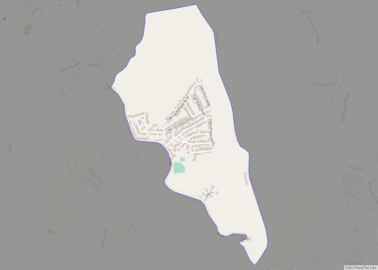
Marueño (Barrio Marueño) is one of the 31 barrios of the municipality of Ponce, Puerto Rico. Along with Anón, Coto Laurel, Guaraguao, Quebrada Limón, Real, and San Patricio, and the coastal barrios of Canas and Capitanejo, Marueño is one of the municipality’s nine bordering barrios. Marueño borders the municipality of Peñuelas. The name of this ... Read more
Map of Marueño comunidad
Map of Martorell comunidad
Martorell comunidad overview: Name: Martorell comunidad LSAD Code: 55 LSAD Description: comunidad (suffix) State: Puerto Rico County: Yabucoa Municipio FIPS code: 7251657 Online Interactive Map Martorell online map. Source: Basemap layers from Google Map, Open Street Map (OSM), Arcgisonline, Wmflabs. Boundary Data from Database of Global Administrative Areas. Martorell location map. Where is Martorell comunidad? ... Read more
Map of Martorell comunidad
Map of Maricao zona urbana
Maricao zona urbana overview: Name: Maricao zona urbana LSAD Code: 62 LSAD Description: zona urbana (suffix) State: Puerto Rico County: Maricao Municipio FIPS code: 7251270 Online Interactive Map Maricao online map. Source: Basemap layers from Google Map, Open Street Map (OSM), Arcgisonline, Wmflabs. Boundary Data from Database of Global Administrative Areas. Maricao location map. Where ... Read more
Map of Maricao zona urbana
Map of Mariano Colón comunidad
Mariano Colón comunidad overview: Name: Mariano Colón comunidad LSAD Code: 55 LSAD Description: comunidad (suffix) State: Puerto Rico County: Coamo Municipio, Santa Isabel Municipio FIPS code: 7251055 Online Interactive Map Mariano Colón online map. Source: Basemap layers from Google Map, Open Street Map (OSM), Arcgisonline, Wmflabs. Boundary Data from Database of Global Administrative Areas. Mariano ... Read more
Map of Mariano Colón comunidad
Map of Maguayo comunidad
Maguayo is a barrio in the municipality of Dorado, Puerto Rico. Its population in 2010 was 4,496. Maguayo comunidad overview: Name: Maguayo comunidad LSAD Code: 55 LSAD Description: comunidad (suffix) State: Puerto Rico County: Lajas Municipio Elevation: 135 ft (41 m) Total Area: 3.88 sq mi (10.0 km²) Land Area: 3.86 sq mi (10.0 km²) Water Area: 0.02 sq mi (0.05 km²) Total Population: 4,496 Population ... Read more
Map of Maguayo comunidad
Map of Magas Arriba comunidad
Magas Arriba comunidad overview: Name: Magas Arriba comunidad LSAD Code: 55 LSAD Description: comunidad (suffix) State: Puerto Rico County: Guayanilla Municipio FIPS code: 7248604 Online Interactive Map Magas Arriba online map. Source: Basemap layers from Google Map, Open Street Map (OSM), Arcgisonline, Wmflabs. Boundary Data from Database of Global Administrative Areas. Magas Arriba location map. ... Read more
Map of Magas Arriba comunidad
Map of Orocovis zona urbana
Orocovis is a barrio in the municipality of Orocovis, Puerto Rico. Its population in 2010 was 3,658. Orocovis zona urbana overview: Name: Orocovis zona urbana LSAD Code: 62 LSAD Description: zona urbana (suffix) State: Puerto Rico County: Orocovis Municipio Elevation: 2,037 ft (621 m) Total Area: 2.96 sq mi (7.7 km²) Land Area: 2.96 sq mi (7.7 km²) Water Area: 0 sq mi (0 km²) Total ... Read more
Map of Orocovis zona urbana
Map of Olimpo comunidad
Olimpo comunidad overview: Name: Olimpo comunidad LSAD Code: 55 LSAD Description: comunidad (suffix) State: Puerto Rico County: Guayama Municipio FIPS code: 7257075 Online Interactive Map Olimpo online map. Source: Basemap layers from Google Map, Open Street Map (OSM), Arcgisonline, Wmflabs. Boundary Data from Database of Global Administrative Areas. Olimpo location map. Where is Olimpo comunidad? ... Read more
Map of Olimpo comunidad
Map of Naranjito zona urbana
Naranjito zona urbana overview: Name: Naranjito zona urbana LSAD Code: 62 LSAD Description: zona urbana (suffix) State: Puerto Rico County: Naranjito Municipio FIPS code: 7256129 Online Interactive Map Naranjito online map. Source: Basemap layers from Google Map, Open Street Map (OSM), Arcgisonline, Wmflabs. Boundary Data from Database of Global Administrative Areas. Naranjito location map. Where ... Read more
Map of Naranjito zona urbana
Map of Mucarabones comunidad
Mucarabones is a barrio in the municipality of Toa Alta, Puerto Rico. Its population in 2010 was 23,221. Mucarabones comunidad overview: Name: Mucarabones comunidad LSAD Code: 55 LSAD Description: comunidad (suffix) State: Puerto Rico County: Toa Alta Municipio Elevation: 66 ft (20 m) Total Area: 5.33 sq mi (13.8 km²) Land Area: 5.32 sq mi (13.8 km²) Water Area: 0.01 sq mi (0.03 km²) Total Population: ... Read more
Map of Mucarabones comunidad
Map of Mora comunidad, Puerto Rico
Mora is a barrio in the municipality of Isabela, Puerto Rico. Its population in 2010 was 4,682. Mora comunidad overview: Name: Mora comunidad LSAD Code: 55 LSAD Description: comunidad (suffix) State: Puerto Rico County: Isabela Municipio Elevation: 322 ft (98 m) Total Area: 2.38 sq mi (6.2 km²) Land Area: 2.38 sq mi (6.2 km²) Water Area: 0 sq mi (0 km²) Total Population: 4,682 Population ... Read more
Map of Mora comunidad, Puerto Rico
Map of Monte Verde comunidad
Monte Verde comunidad overview: Name: Monte Verde comunidad LSAD Code: 55 LSAD Description: comunidad (suffix) State: Puerto Rico County: Ponce Municipio FIPS code: 7254688 Online Interactive Map Monte Verde online map. Source: Basemap layers from Google Map, Open Street Map (OSM), Arcgisonline, Wmflabs. Boundary Data from Database of Global Administrative Areas. Monte Verde location map. ... Read more
Map of Monte Verde comunidad