Map of Harmony CDP, Rhode Island

Map of Harmony CDP, Rhode Island

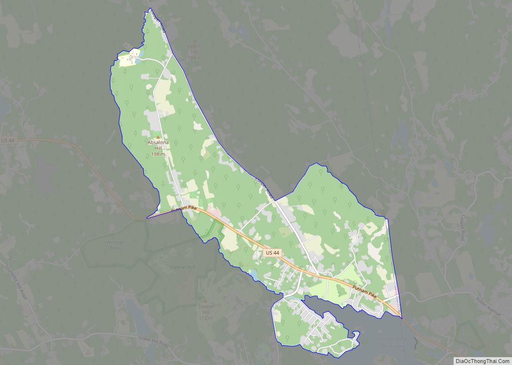
Harmony is a village and census-designated place in Providence County, Rhode Island, in the town of Glocester, located on U.S. Route 44 (Putnam Pike). As of the 2010 census, it had a population of 985. Harmony CDP overview: Name: Harmony CDP LSAD Code: 57 LSAD Description: CDP (suffix) State: Rhode Island County: Providence County Elevation: … Read more

Map of Greenville CDP, Rhode Island

Map of Greenville CDP, Rhode Island

Greenville is a village and census-designated place (CDP) in the town of Smithfield in Providence County, Rhode Island, United States. The population was 8,658 at the 2010 census. The CDP is centered on the village of Greenville but also encompasses the nearby villages of West Greenville and Spragueville, as well as the Mountaindale Reservoir and … Read more

Map of Valley Falls CDP, Rhode Island

Map of Valley Falls CDP, Rhode Island

Valley Falls is a village and census-designated place (CDP) in the town of Cumberland, Providence County, Rhode Island, United States. The population was 12,094 at the 2020 census. Warren Buffett’s company Berkshire Hathaway was founded in 1839 by Oliver Chace in Valley Falls as a cotton-manufacturing company, called the Valley Falls Company. Valley Falls is … Read more

Map of Tiverton CDP

Map of Tiverton CDP

Tiverton is a census-designated place (CDP) in Newport County, Rhode Island, United States. The CDP encompasses the town center of Tiverton and the adjacent village of North Tiverton. The population of the CDP was 7,557 at the 2010 census. Tiverton CDP overview: Name: Tiverton CDP LSAD Code: 57 LSAD Description: CDP (suffix) State: Rhode Island … Read more

Map of Quonochontaug CDP

Map of Quonochontaug CDP

Quonochontaug is a village in Washington County, Rhode Island, United States. It is composed of three small beach communities, and is part of Charlestown. Quonochontaug CDP overview: Name: Quonochontaug CDP LSAD Code: 57 LSAD Description: CDP (suffix) State: Rhode Island County: Washington County Elevation: 322 ft (98 m) ZIP code: 02813 Area code: 401 FIPS code: 4460260 … Read more

Map of Pascoag CDP

Map of Pascoag CDP

Pascoag /ˈpæskoʊɡ/ is a census-designated place (CDP) and village in Providence County, Rhode Island. The population was 4,577 at the 2010 census. Pascoag is one of eight villages that make up the town of Burrillville. Pascoag CDP overview: Name: Pascoag CDP LSAD Code: 57 LSAD Description: CDP (suffix) State: Rhode Island County: Providence County Elevation: … Read more

Map of Wyoming CDP, Rhode Island

Map of Wyoming CDP, Rhode Island

Wyoming is a village and census-designated place on the Wood River in southern Rhode Island, primarily in the town of Richmond, Rhode Island, but extending north across the river (which defines the town line) into the town of Hopkinton, Rhode Island. The population was 270 at the 2010 census. It is the site of the … Read more

Map of Woonsocket city

Map of Woonsocket city, Rhode Island

Woonsocket (/wʊnˈsɒkɪt, wən-/ (listen) wuun-SOK-it, wən-), is a city in Providence County, Rhode Island, United States. The population was 43,240 at the 2020 census, making it the sixth largest city in the state. Being Rhode Island’s northernmost city, Woonsocket lies directly south of the Massachusetts state line and constitutes part of both the Providence metropolitan … Read more

Map of Westerly CDP

Map of Westerly CDP

Westerly is a census-designated place (CDP) in the town of Westerly in Washington County, Rhode Island, United States. The population was 17,682 at the 2000 census. Westerly CDP overview: Name: Westerly CDP LSAD Code: 57 LSAD Description: CDP (suffix) State: Rhode Island County: Washington County Total Area: 16.52 sq mi (42.79 km²) Land Area: 15.83 sq mi (41.01 km²) Water Area: … Read more

Map of Weekapaug CDP

Map of Weekapaug CDP

Weekapaug (/ˈwiːkəpɔːɡ/) is a census-designated place in southern Washington County, Rhode Island, part of the town of Westerly, Rhode Island. The population was 425 at the 2010 census. Weekapaug CDP overview: Name: Weekapaug CDP LSAD Code: 57 LSAD Description: CDP (suffix) State: Rhode Island County: Washington County Elevation: 7 ft (2 m) Total Area: 1.20 sq mi (3.10 km²) Land … Read more

Map of Watch Hill CDP

Map of Watch Hill CDP

Watch Hill is an affluent coastal neighborhood and census-designated place in the town of Westerly, Rhode Island. The population was 154 at the 2010 census. It sits at the most-southwestern point in all of Rhode Island. It came to prominence in the late 19th and early 20th century as an exclusive summer resort, with wealthy … Read more

Map of Wakefield-Peacedale CDP

Map of Wakefield-Peacedale CDP

Wakefield-Peacedale (listed as “Wakefield-Peace Dale” by the United States Census Bureau) is a census-designated place (CDP) in the town of South Kingstown in Washington County, Rhode Island, United States that includes the villages of Peace Dale and Wakefield. The population was 8,487 at the 2010 census. Wakefield-Peacedale CDP overview: Name: Wakefield-Peacedale CDP LSAD Code: 57 … Read more