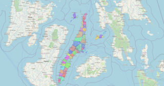
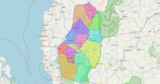
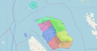
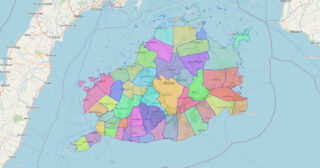
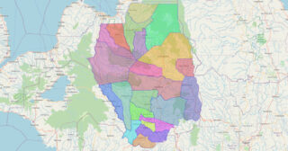
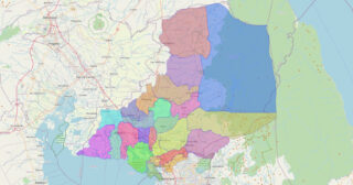
Map of Isabela Province
Isabela, officially the Province of Isabela (Ilocano: Probinsia ti Isabela; Ibanag: Provinsia na Isabela; Tagalog: Lalawigan ng Isabela), is the second largest province in the Philippines in land area located in the Cagayan Valley. Its capital and the largest local government unit is the city of Ilagan. It is bordered by the provinces of Cagayan ... Read more
Map of Isabela Province
Map of Catanduanes Province
Catanduanes (/ˌkɑːtɑːnˈdwɑːnɛs/; Tagalog pronunciation: [kɐtɐnˈdwɐnes]), officially the Province of Catanduanes (Filipino: Lalawigan ng Catanduanes), is an island province located in the Bicol Region of Luzon in the Philippines. It is the 12th-largest island in the Philippines, and lies to the east of Camarines Sur, across the Maqueda Channel. Its capital is Virac, the most populous ... Read more
Map of Catanduanes Province
Map of Kalinga Province
Kalinga (IPA: [ka’liŋɡa]), officially the Province of Kalinga (Ilocano: Probinsia ti Kalinga; Tagalog: Lalawigan ng Kalinga), is a landlocked province in the Philippines situated within the Cordillera Administrative Region in Luzon. Its capital (and largest city) is Tabuk and borders Mountain Province to the south, Abra to the west, Isabela to the east, Cagayan to ... Read more
Map of Kalinga Province
Map of Aurora Province
Aurora, officially the Province of Aurora (Filipino: Lalawigan ng Aurora; Ilocano: Probinsia ti Aurora), is a province in the Philippines located in the eastern part of Central Luzon region, facing the Philippine Sea. Its capital is Baler and borders, clockwise from the south, the provinces of Quezon, Bulacan, Nueva Ecija, Nueva Vizcaya, Quirino, and Isabela. ... Read more
Map of Aurora Province
Map of Basilan Province
Basilan, officially the Province of Basilan (Chavacano: Provincia de Basilan; Yakan: Wilayah Basilanin; Tausug: Wilaya’ sin Basilan; Filipino: Lalawigan ng Basilan), is an island province of the Philippines located primarily in the Bangsamoro Autonomous Region. Basilan Island is the largest and northernmost of the major islands of the Sulu Archipelago. It is just off the ... Read more
Map of Basilan Province
Map of Bataan Province
Bataan (/bɑːtɑːˈʔɑːn/, /bɑːˈtɑːn/), officially the Province of Bataan (Filipino: Lalawigan ng Bataan IPA: [bɐtɐˈʔan]), is a province in the Central Luzon region of the Philippines. Its capital is the city of Balanga while Mariveles is the largest town in the province. Occupying the entire Bataan Peninsula on Luzon, Bataan is bordered by the provinces of ... Read more
Map of Bataan Province
Map of Batanes Province
Batanes, officially the Province of Batanes (Ivatan: Provinsiya nu Batanes; Ilocano: Probinsia ti Batanes; Filipino: Lalawigan ng Batanes, IPA: [bɐˈtanes]), is an archipelagic province in the Philippines, administratively part of the Cagayan Valley region. It is the northernmost province in the Philippines, and the smallest, both in population and land area. The capital is Basco, ... Read more
Map of Batanes Province
Map of Batangas Province
Batangas, officially the Province of Batangas (Tagalog: Lalawigan ng Batangas IPA: [bɐˈtaŋgas]), is a first class province of the Philippines located in the southwestern part of Luzon in the Calabarzon region. Its capital is the city of Batangas, and is bordered by the provinces of Cavite and Laguna to the north, and Quezon to the ... Read more
Map of Batangas Province
Map of Benguet Province
Benguet (IPA: [bɛŋˈɡɛt]), officially the Province of Benguet (Ibaloi: Probinsya ne Benguet; Kankanaey: Probinsyan di Benguet; Pangasinan: Luyag/Probinsia na Benguet; Ilocano: Probinsia ti Benguet; Filipino: Lalawigan ng Benguet), is a landlocked province of the Philippines located in the southern tip of the Cordillera Administrative Region in the island of Luzon. Its capital is La Trinidad. ... Read more
Map of Benguet Province
Map of Biliran Province
Biliran, officially the Province of Biliran (Waray-Waray: Probinsya han Biliran; Cebuano: Lalawigan sa Biliran; Tagalog: Lalawigan ng Biliran), is an island province in the Philippines located in the Eastern Visayas region (Region VIII). Biliran is one of the country’s smallest and newest provinces. Formerly a sub-province of Leyte, it became an independent province in 1992. ... Read more
Map of Biliran Province
Map of Bohol Province
Bohol (Tagalog pronunciation: [buˈhol]), officially the Province of Bohol (Cebuano: Lalawigan sa Bohol; Hiligaynon: Kapuoran sang Bohol; Tagalog: Lalawigan ng Bohol), is an island province of the Philippines located in the Central Visayas region, consisting of the island itself and 75 minor surrounding islands. Its capital is Tagbilaran, the largest city of the province. With ... Read more
Map of Bohol Province
Map of Bukidnon Province
Bukidnon (/buːˈkɪdnɒn/), officially the Province of Bukidnon (Cebuano: Lalawigan sa Bukidnon; Filipino: Lalawigan ng Bukidnon; Hiligaynon: Kapuroan sang Bukidnon; Binukid and Higaonon: Probinsya ta Bukidnon), is a landlocked province in the Philippines located in the Northern Mindanao region. Its capital is the city of Malaybalay while Valencia is the largest city. The province borders, clockwise ... Read more
Map of Bukidnon Province