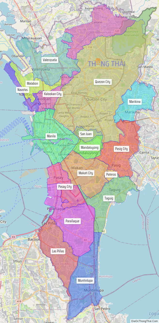
Metropolitan Manila (Filipino: Kalakhang Maynila), commonly shortened to Metro Manila and formally the National Capital Region (NCR; Filipino: Pambansang Punong Rehiyon), is the capital region and largest metropolitan area of the Philippines. Located on the eastern shore of Manila Bay, the region lies between the Central Luzon and Calabarzon regions. Encompassing an area of 636.00 km (245.56 sq mi) and with a population of 13,484,462 as of 2020, it is composed of sixteen highly urbanized cities: the capital city, Manila, Caloocan, Las Piñas, Makati, Malabon, Mandaluyong, Marikina, Muntinlupa, Navotas, Parañaque, Pasay, Pasig, Quezon City, San Juan, Taguig, and Valenzuela, along with one independent municipality, Pateros. As the second most populous and the most densely populated region in the Philippines, it ranks as the 9th most populous metropolitan area in Asia and the 6th most populous urban area in the world.
The region is the center of culture (including arts and entertainment), economy, education and government of the Philippines. Designated as a global power city, the region exerts a significant impact on commerce, finance, media, art, fashion, research, technology, education, and entertainment, both locally and internationally. It is the home to all embassies in the Philippines, thereby making it an important center for international diplomacy in the country. Its economic power makes the region the country’s premier center for finance and commerce. The region accounts for 36% of the gross domestic product (GDP) of the Philippines. Greater Manila is the fourth largest ASEAN country subdivision by GDP after Singapore, Jakarta and Bangkok.
In 1975, in response to the need to sustain and provide integrated services to the growing population, the built-up area centered on Manila was formally recognized as a metropolitan area through Presidential Decree No. 824. A year later, Presidential Decree No. 879 established Metro Manila as an administrative region, retaining its earlier status as a metropolis, and was designated as Region IV, with the remainder of the Southern Tagalog region being designated as Region IV-A. Finally, in 1978, Metro Manila became the National Capital Region (NCR) of the Philippines, discontinuing its numerical designation and reverting it to Southern Tagalog.
| Type: | Metropolitan area and region |
|---|---|
| Capital: | Manila |
| Density: | 12.37% |
| ISO 3166 code: | PH-00 |
| Website: | mmda.gov.ph |
Online Interactive Map
Explore the interactive online map of Metropolitan Manila, which highlights the administrative boundaries with each sub-administrative unit distinctly colored for easy identification. Just click on the map, and the name of the sub-unit will display, providing an intuitive and engaging way to navigate the area. Users can also view the map in full screen and switch between different map views, including OpenStreetMap, Google Maps, and satellite imagery.
Click on ![]() to view map in "full screen" mode.
to view map in "full screen" mode.
Metropolitan Manila Political Map
Map of Metropolitan Manila, Philippines the administrative divisions, provincial boundaries, along with detailed depictions of streets, roads, rivers, landmarks, and other geographical features.


