Misamis Occidental (Cebuano: Kasadpang Misamis; Subanen: Sindepan Mis’samis; Maranao: Sedepan Misamis; Filipino: Kanlurang Misamis), officially the Province of Misamis Occidental, is a province located in the region of Northern Mindanao in the Philippines. Its capital is the city of Oroquieta while Ozamiz is the most-populous city. The province borders Zamboanga del Norte and Zamboanga del Sur to the west and is separated from Lanao del Norte by Panguil Bay to the south and Iligan Bay to the east. The province of Misamis was originally inhabited by Subanens who were an easy target by the sea pirates from Lanao.
The province is named after the early settlement of the Spaniards at the entrance to the Panguil Bay. The name Misamis is believed to have been derived from the Subanen word kuyamis which is a variety of coconut, the staple food of the early settlers. During the years the name persisted as an inference of the geographical location, and upon the advent of the Spanish settlers, the word kuyamis easily gave way to the more convenient pronounceable but corrupted word Misamis.
| Type: | Province |
|---|---|
| Capital: | Oroquieta |
| Area: | 2,006.63 km (774.76 sq mi) |
| Area Rank: | 60th out of 81 |
| Population: | 617,333 |
| Population Rank: | 50th out of 81 |
| Density: | 0.57% |
| ZIP code: | 7200–7215 |
| ISO 3166 code: | PH-MSC |
| Website: | misocc.gov.ph |
Online Interactive Map
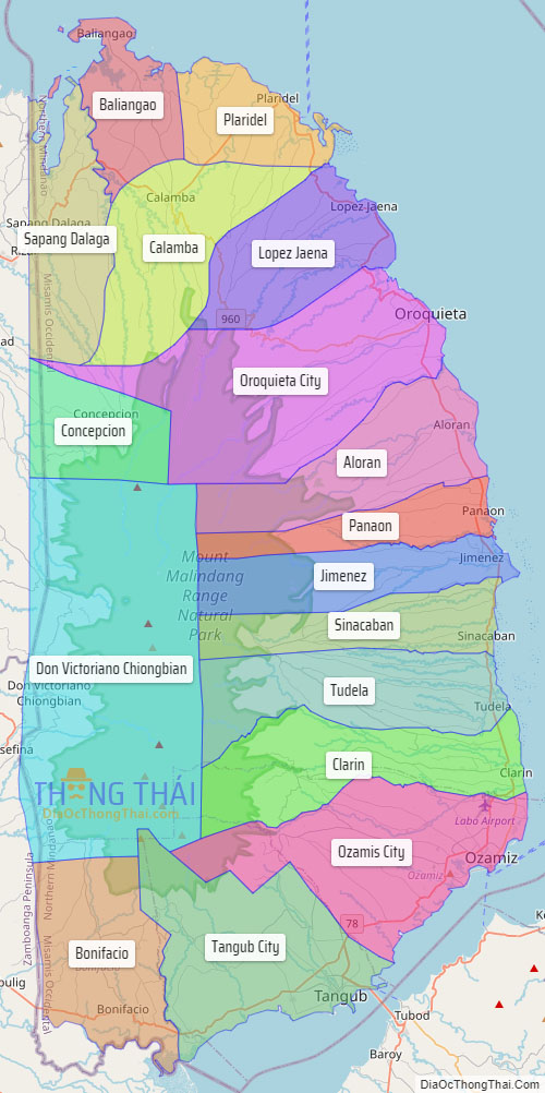
Explore the interactive online map of Misamis Occidental, which highlights the administrative boundaries with each sub-administrative unit distinctly colored for easy identification. Just click on the map, and the name of the sub-unit will display, providing an intuitive and engaging way to navigate the area. Users can also view the map in full screen and switch between different map views, including OpenStreetMap, Google Maps, and satellite imagery.
Click on ![]() to view map in "full screen" mode.
to view map in "full screen" mode.
Misamis Occidental Political Map
Map of Misamis Occidental Province, Philippines the administrative divisions, provincial boundaries, along with detailed depictions of streets, roads, rivers, landmarks, and other geographical features.


