Pangasinan, officially the Province of Pangasinan (Pangasinan: Luyag/Probinsia na Pangasinan, [paŋɡasiˈnan]; Ilocano: Probinsia ti Pangasinan; Tagalog: Lalawigan ng Pangasinan), is a coastal province in the Philippines located in the Ilocos Region of Luzon. Its capital is Lingayen while San Carlos City is the most populous. Pangasinan is in the western area of Luzon along Lingayen Gulf and the South China Sea. It has a total land area of 5,451.01 square kilometres (2,104.65 sq mi). According to the 2020 census, it has a population of 3,163,190. The official number of registered voters in Pangasinan is 1,651,814. The western portion of the province is part of the homeland of the Sambal people, while the central and eastern portions are the homeland of the Pangasinan people. Due to ethnic migration, the Ilocano people settled in the province.
Pangasinan is the name of the province, the people and the spoken language. Indigenous Pangasinan speakers are estimated to number at least 2 million. The Pangasinan language, which is official in the province, is one of the officially recognized regional languages in the Philippines. Several ethnic groups enrich the cultural fabric of the province. Almost all of the people are Pangasinans and the rest are descendants of the Bolinao and Ilocano who settled the eastern and western parts of the province. Pangasinan is spoken as a second language by many ethnic minorities in Pangasinan. The minority ethnic groups are the Bolinao-speaking Zambals, and Ilocanos.
Popular tourist attractions in Pangasinan include the Hundred Islands National Park in Alaminos the white-sand beaches of Bolinao and Dasol. Dagupan is known for its Bangus Festival (“Milkfish Festival”). Pangasinan is also known for its mangoes and ceramic oven-baked Calasiao puto (“native rice cake”). Pangasinan occupies a strategic geo-political position in the central plain of Luzon. Pangasinan has been described as the gateway to northern Luzon.
| Type: | Province |
|---|---|
| Capital: | Lingayen |
| Area: | 5,451.01 km (2,104.65 sq mi) |
| Area Rank: | 15th out of 81 |
| Population: | 3,163,190 |
| Population Rank: | 6th out of 81 |
| Density: | 2.90% |
| ZIP code: | 2400–2447 |
| ISO 3166 code: | PH-PAN |
| Website: | www.pangasinan.gov.ph |
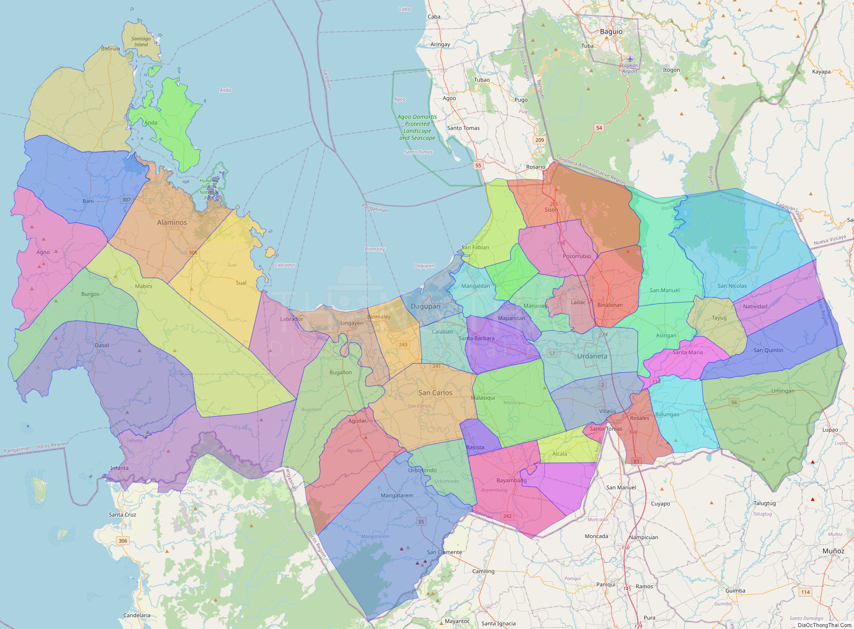
Online Interactive Map
Explore the interactive online map of Pangasinan, which highlights the administrative boundaries with each sub-administrative unit distinctly colored for easy identification. Just click on the map, and the name of the sub-unit will display, providing an intuitive and engaging way to navigate the area. Users can also view the map in full screen and switch between different map views, including OpenStreetMap, Google Maps, and satellite imagery.
Click on ![]() to view map in "full screen" mode.
to view map in "full screen" mode.
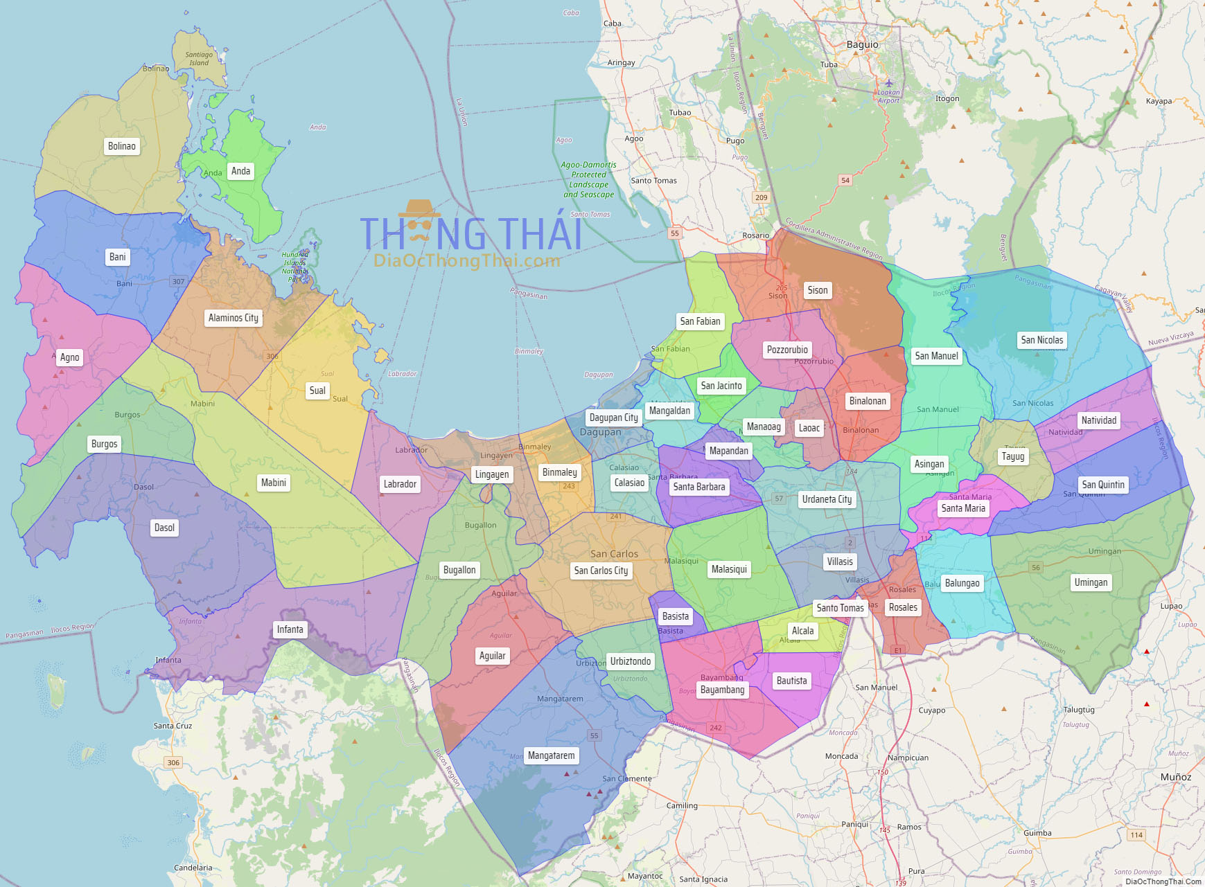
Pangasinan Political Map
Map of Pangasinan Province, Philippines the administrative divisions, provincial boundaries, along with detailed depictions of streets, roads, rivers, landmarks, and other geographical features.