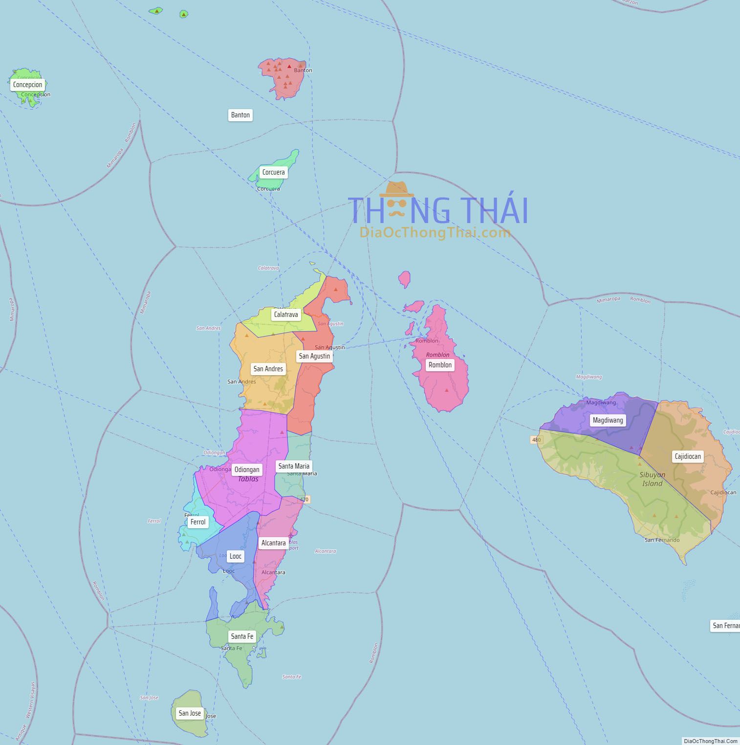
Romblon (/rɒmˈbloʊn/ rom-BLOHN, Tagalog: [ɾomˈblon]), officially the Province of Romblon, is an archipelagic province of the Philippines located in the Mimaropa region. Its main components include Romblon, Romblon, an archipelagic municipality of the same name that also serves as the provincial capital; Tablas, the largest island, covering nine municipalities (including Odiongan, the largest municipality in the province); Sibuyan with its three towns; as well as the smaller island municipalities of Corcuera, Banton, Concepcion, San Jose. The province lies south of Marinduque and Quezon, east of Oriental Mindoro, north of Aklan and Capiz, and west of Masbate. According to the 2020 census, it has a total population of 308,985.
Romblon was inhabited by aboriginal Filipinos prior to the arrival of the Spanish in 1569. Archaeological artifacts recovered by the National Museum in 1936 indicate that the aborigines of Romblon have a rich and advanced culture. During the Spanish colonial rule, Romblon was initially administered under the province of Arevalo (Iloilo) until 1716, when it was transferred to the jurisdiction of the newly created province of Capiz. With arrival of the Americans in 1901, Romblon was declared a province and placed under civilian rule. It lost its provincial status for a short while between 1907 and 1945, but regained it in 1946, just after World War II.
The inhabitants of Romblon are divided into three ethnolinguistic groups: Romblomanon, Onhan and Asi. These groups occupy specific islands in the province and have their own language and customs. Romblomanon is mainly spoken in the town of Romblon, in all of three towns of Sibuyan Island, and the town of San Agustin in Tablas. Onhan is mainly spoken in the municipalities in the southern part of Tablas (Alcantara, Looc, Ferrol, Santa Fe, San Andres, and Santa Maria), as well as in the island municipality of San Jose. The northwestern part of Tablas Island (in Odiongan and Calatrava, as well as the islands municipalities of Corcuera, Banton, and Concepcion), speaks the Asi language.
The province relies on agriculture, particularly rice and copra farming as well as fishing, for its livelihood. It also has a lucrative marble industry due to an abundance of Italian-quality marble, hence, its moniker as the “Marble Capital of the Philippines.” The islands of the province have a number of white sand beaches, diving spots, mountains and rainforests that tourists visit. Sibuyan island is an ecotourism destination, having been dubbed by some as “the Galápagos of Asia” because it has remained in isolation from the rest of the world since its formation.
| Type: | Province |
|---|---|
| Capital: | Romblon |
| Area: | 1,533.45 km (592.07 sq mi) |
| Area Rank: | 68th out of 81 |
| Population: | 308,985 |
| Population Rank: | 66th out of 81 |
| Density: | 0.28% |
| ZIP code: | 5500–5515 |
| ISO 3166 code: | PH-ROM |
Online Interactive Map
Explore the interactive online map of Romblon, which highlights the administrative boundaries with each sub-administrative unit distinctly colored for easy identification. Just click on the map, and the name of the sub-unit will display, providing an intuitive and engaging way to navigate the area. Users can also view the map in full screen and switch between different map views, including OpenStreetMap, Google Maps, and satellite imagery.
Click on ![]() to view map in "full screen" mode.
to view map in "full screen" mode.
Romblon Political Map
Map of Romblon Province, Philippines the administrative divisions, provincial boundaries, along with detailed depictions of streets, roads, rivers, landmarks, and other geographical features.


