Southern Leyte (Cebuano: Habagatang Leyte; Kabalian: Habagatan nga Leyte; Waray: Salatan nga Leyte; Tagalog: Timog Leyte), officially the Province of Southern Leyte, is a province in the Philippines located in the Eastern Visayas region. Its capital and largest city is Maasin. Southern Leyte comprised the third congressional district Leyte until it was made into an independent province in 1959. Southern Leyte includes Limasawa, an island to the south where the first Roman Catholic Mass in Philippine soil is believed to have taken place and thus considered to be the birthplace of Roman Catholicism in the Philippines.
The province ranks as the second least populated in the region, after the province of Biliran. According to the 2020 census, the province has a population of 429,573.
Southern Leyte’s geological features created several issues in the province after the flooding of the Subangdaku River and the 2006 mudslide in Guinsaugon. Organizations warned the province it was susceptible to natural occurrences like landslides and floods.
Southern Leyte forms an important part of the inter-island transportation system of the country, with ferries transporting people and goods between Liloan and Surigao del Norte in Mindanao. The province is well known for its quality abaca products and is the country’s major producer of abaca fiber.
In September 2017, Representative Roger Mercado authored House Bill 6408, proposing to change the name of the province to Leyte del Sur.
| Type: | Province |
|---|---|
| Capital: | Maasin |
| Area: | 1,798.61 km (694.45 sq mi) |
| Area Rank: | 65th out of 81 |
| Population: | 429,573 |
| Population Rank: | 63rd out of 81 |
| Density: | 0.39% |
| ZIP code: | 6600–6618 |
| ISO 3166 code: | PH-SLE |
| Website: | www.southernleyte.gov.ph |
Online Interactive Map
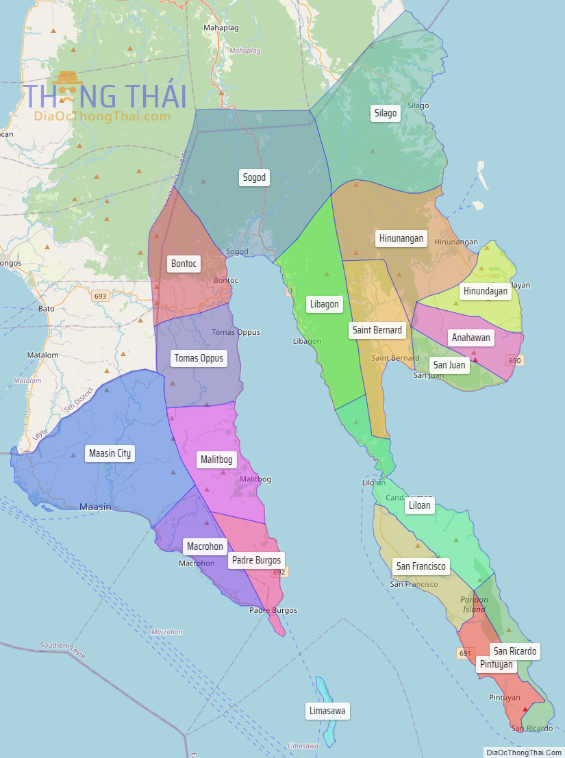
Explore the interactive online map of Southern Leyte, which highlights the administrative boundaries with each sub-administrative unit distinctly colored for easy identification. Just click on the map, and the name of the sub-unit will display, providing an intuitive and engaging way to navigate the area. Users can also view the map in full screen and switch between different map views, including OpenStreetMap, Google Maps, and satellite imagery.
Click on ![]() to view map in "full screen" mode.
to view map in "full screen" mode.
Southern Leyte Political Map
Map of Southern Leyte Province, Philippines the administrative divisions, provincial boundaries, along with detailed depictions of streets, roads, rivers, landmarks, and other geographical features.


