Map of Stevens Village CDP

Map of Stevens Village CDP

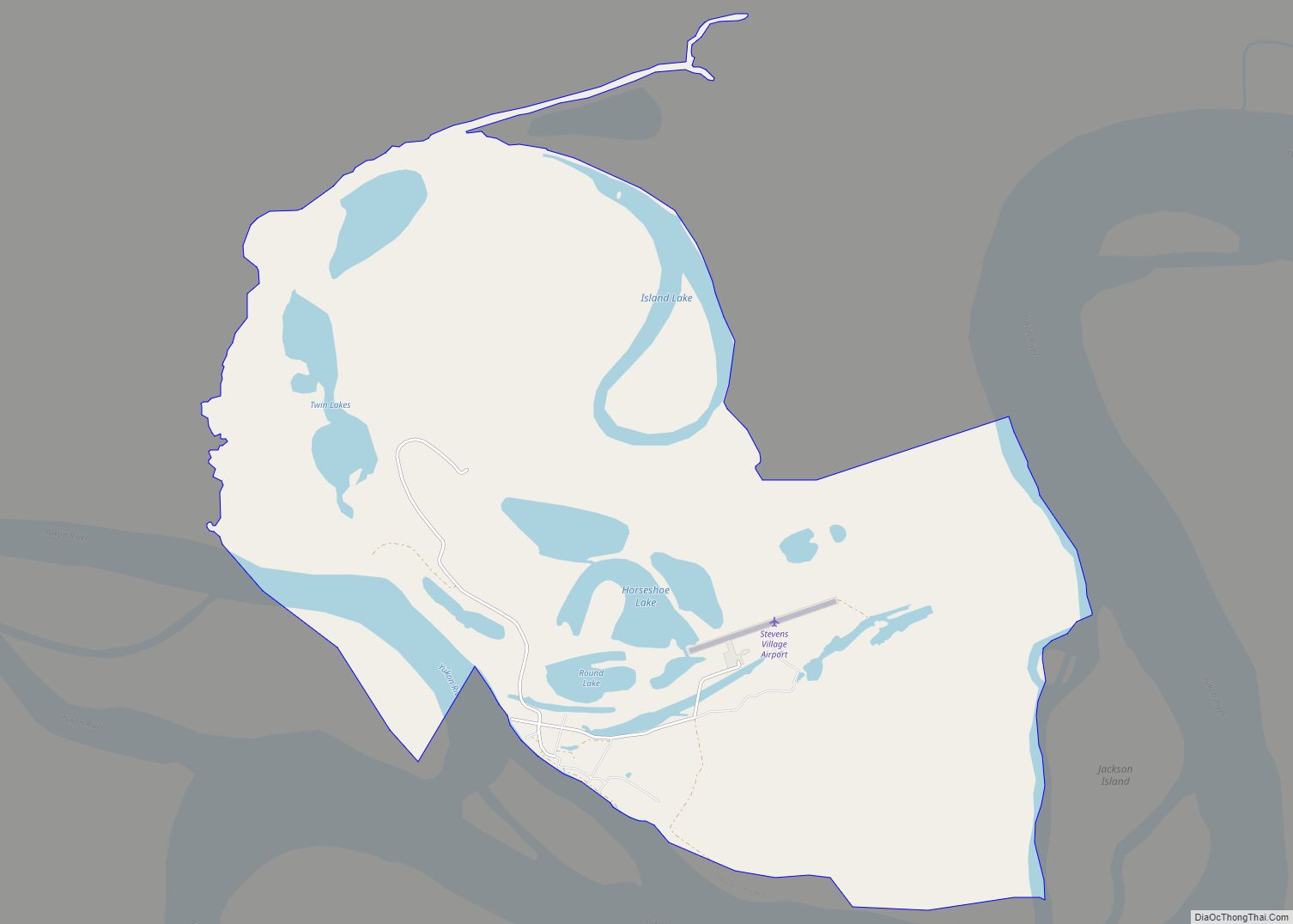
Stevens Village (Denyeet in Koyukon) is a census-designated place (CDP) in Yukon-Koyukuk Census Area, Alaska, United States. The population was 78 at the 2010 census, down from 87 in 2000. The village is named for its first chief, Skidedlestalk “Old Steven” Stevens (1850-d. 1912~1920). Stevens Village CDP overview: Name: Stevens Village CDP LSAD Code: 57 … Read more

Map of Sterling CDP

Map of Sterling CDP, Alaska

Sterling is a census-designated place (CDP) in Kenai Peninsula Borough, Alaska, United States. At the 2020 census the population was 5,918, up from 5,617 in 2010. Sterling is the tenth-most populated CDP in Alaska. Sterling CDP overview: Name: Sterling CDP LSAD Code: 57 LSAD Description: CDP (suffix) State: Alaska County: Kenai Peninsula Borough Elevation: 220 ft … Read more

Map of Steele Creek CDP

Map of Steele Creek CDP

Steele Creek is a census-designated place (CDP) in Fairbanks North Star Borough, Alaska, United States. It is part of the Fairbanks, Alaska Metropolitan Statistical Area. As of the 2020 census, the population was 6,437, down from 6,662 in 2010. It is the eighth-most populated CDP in Alaska. Steele Creek CDP overview: Name: Steele Creek CDP … Read more

Map of Stony River CDP

Map of Stony River CDP

Stony River (Gidighuyghatno’ Xidochagg Qay’ in Deg Xinag, K’qizaghetnu Hdakaq’ in Dena’ina) is a census-designated place (CDP) in Bethel Census Area, Alaska, United States. The population was 54 at the 2010 census, down from 61 in 2000. Native inhabitants are mixed Athabaskan and Yup’ik ancestry of Alaska Native. Stony River village is the modern contact … Read more

Map of Susitna North CDP

Map of Susitna North CDP

Susitna North is a census-designated place (CDP) in the Matanuska-Susitna Borough in the U.S. state of Alaska. It is part of the Anchorage, Alaska Metropolitan Statistical Area. The population was 1,564 at the 2020 census, up from 1,260 in 2010. The CDP was formerly named Y /ˈwaɪ/, for the intersection of the George Parks Highway … Read more

Map of Sunrise CDP

Map of Sunrise CDP, Alaska

Sunrise is a census-designated place (CDP) in Kenai Peninsula Borough, Alaska, United States. The population was 18 at the 2010 census, unchanged from 2000. Sunrise CDP overview: Name: Sunrise CDP LSAD Code: 57 LSAD Description: CDP (suffix) State: Alaska County: Kenai Peninsula Borough Elevation: 269 ft (82 m) Total Area: 13.02 sq mi (33.73 km²) Land Area: 13.02 sq mi (33.73 km²) Water … Read more

Map of Takotna CDP

Map of Takotna CDP

Takotna(Tochotno’) IPA: [tʰot͡ʃʰoʔno] in Upper Kuskokwim) is a census-designated place (CDP) in the Yukon-Koyukuk Census Area, Alaska, United States. The population was 52 as of the 2010 Census, an increase of 4% from 50 at the 2000 Census. Takotna CDP overview: Name: Takotna CDP LSAD Code: 57 LSAD Description: CDP (suffix) State: Alaska County: Yukon-Koyukuk Census … Read more

Map of Sutton-Alpine CDP

Map of Sutton-Alpine CDP

Sutton (Ahtna: Ts’es Tac’ilaexde; Dena’ina: Ts’es Tuk’ilaght) is a census-designated place (CDP) in the Matanuska-Susitna Borough in the U.S. state of Alaska. At the 2020 census the population was 1,038, down from 1,447 in 2010. The CDP includes the former coal mining community and road construction camp of Sutton, as well as the former mining camps of … Read more

Map of Susitna CDP

Map of Susitna CDP

Susitna is a census-designated place (CDP) in Matanuska-Susitna Borough, Alaska, United States. It is part of the Anchorage Metropolitan Area. As of the 2020 census, the population of the CDP was 11. Susitna was once home to the legendary Athabaskan elder, historian and ethnologist Shem Pete (c1896-1989), who documented countless locations travelling thousands of miles … Read more

Map of Tanaina CDP

Map of Tanaina CDP

Tanaina is a census-designated place (CDP) in the Matanuska-Susitna Borough in the U.S. state of Alaska. Located 4 miles north from Wasilla, it is part of the Anchorage, Alaska Metropolitan Statistical Area. At the 2020 census the population was 8,817, up from 8,197 in 2010. Tanaina is the sixth-most populated CDP in Alaska. Tanaina CDP … Read more

Map of Tanacross CDP

Map of Tanacross CDP

Tanacross (Taats’altęy in Tanacross Athabascan) is a census-designated place (CDP) in Southeast Fairbanks Census Area, Alaska, United States. At the 2010 census the population was 136, down from 140 in 2000. It hosts an air tanker base. Tanacross CDP overview: Name: Tanacross CDP LSAD Code: 57 LSAD Description: CDP (suffix) State: Alaska County: Southeast Fairbanks … Read more

Map of Talkeetna CDP

Map of Talkeetna CDP

Talkeetna (Dena’ina: K’dalkitnu) is a census-designated place (CDP) in Matanuska-Susitna Borough, Alaska, United States. At the 2020 census the population was 1,055, up from 876 in 2010. Talkeetna CDP overview: Name: Talkeetna CDP LSAD Code: 57 LSAD Description: CDP (suffix) State: Alaska County: Matanuska-Susitna Borough Elevation: 348 ft (106 m) Total Area: 96.35 sq mi (249.54 km²) Land Area: 94.22 sq mi … Read more