Map of Wasilla city

Map of Wasilla city

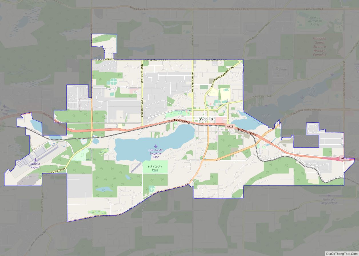
Wasilla (Dena’ina: Benteh) is a city in Matanuska-Susitna Borough, United States and the fourth-largest city in Alaska. It is located on the northern point of Cook Inlet in the Matanuska-Susitna Valley of the southcentral part of the state. The city’s population was 9,054 at the 2020 census, up from 7,831 in 2010. Wasilla is the largest … Read more

Map of Fairbanks city

Map of Fairbanks city

Fairbanks is a home rule city and the borough seat of the Fairbanks North Star Borough in the U.S. state of Alaska. Fairbanks is the largest city in the Interior region of Alaska and the second largest in the state. The 2020 Census put the population of the city proper at 32,515 and the population … Read more

Map of Adak city

Map of Adak city

Adak (/ˈeɪdæk/, Aleut: Adaax, Russian: Адак), formerly Adak Station, is a city located on Adak Island, in the Aleutians West Census Area, Alaska, United States. At the 2020 census, the population was 171, down from 326 in 2010. It is the westernmost municipality in the United States and the southernmost city in Alaska. (See Extreme … Read more

Map of Akiak city

Map of Akiak city

Akiak (ACK-ee-ack) (Central Yupik: Akiaq) is a city in Bethel Census Area, Alaska, United States. The population was 462 at the 2020 census, up from 346 in 2010. It is the home of the Akiak Native Community. Akiak city overview: Name: Akiak city LSAD Code: 25 LSAD Description: city (suffix) State: Alaska County: Bethel Census … Read more

Map of Akiachak CDP

Map of Akiachak CDP

Akiachak (ACK-ee-uh-chuck; Central Yupik: Akiacuaq) is a census-designated place (CDP) in the Bethel Census Area in the U.S. state of Alaska. The population was 627 at the 2010 census, up from 585 in 2000. Akiachak CDP overview: Name: Akiachak CDP LSAD Code: 57 LSAD Description: CDP (suffix) State: Alaska County: Bethel Census Area Elevation: 13 ft … Read more

Map of Akhiok city

Map of Akhiok city

Akhiok (Kasukuak in Alutiiq; Russian: Акхиок) is a second-class city in Kodiak Island Borough, Alaska, United States. Akhiok is Kodiak’s southernmost village. The population was 63 at the 2020 census. Akhiok, which does not have a post office, is a rural location in postal code 99615 that belongs to Kodiak. The village is sometimes called … Read more

Map of Alatna CDP

Map of Alatna CDP

Alatna /əˈlætnə/ (Alaasuq in Iñupiaq [ɐˈlaːsoq]) is a census-designated place (CDP) in the Yukon-Koyukuk Census Area of the Unorganized Borough in the U.S. state of Alaska. The population was 37 at the 2010 census. Alatna CDP overview: Name: Alatna CDP LSAD Code: 57 LSAD Description: CDP (suffix) State: Alaska County: Yukon-Koyukuk Census Area Total Area: … Read more

Map of Alakanuk city

Map of Alakanuk city

Alakanuk (ah-LUG-uh-nuck) (Central Yupik: Alarneq) is a second class city in the Kusilvak Census Area of the Unorganized Borough in the western part of the U.S. state of Alaska. As of the 2010 census, the population of the city was 677, up from 652 in 2000. Alakanuk city overview: Name: Alakanuk city LSAD Code: 25 … Read more

Map of Akutan city

Map of Akutan city

Akutan (/ˈækuːtæn/ AK-oo-tan, Aleut: Achan-ingiiga) is a city on Akutan Island in the Aleutians East Borough of the Aleutian Islands in Alaska, United States. The population was 1,589 at the 2020 census, up from 1,027 in 2010, making it the 4th fastest-growing city of the decade in Alaska. Akutan Harbor is adjacent. Akutan city overview: … Read more

Map of Aleneva CDP

Map of Aleneva CDP

Aleneva is a census-designated place in the Kodiak Island Borough in the U.S. state of Alaska. As of the 2010 census, the population was 37, down from 68 in 2000. Aleneva CDP overview: Name: Aleneva CDP LSAD Code: 57 LSAD Description: CDP (suffix) State: Alaska County: Kodiak Island Borough Elevation: 620 ft (189 m) Total Area: 62.21 sq mi … Read more

Map of Aleknagik city

Map of Aleknagik city

Aleknagik (/əˈlɛknəɡɪk/ ə-LEK-nə-gik; Central Yupik: Alaqnaqiq) is a second class city in the Dillingham Census Area of the Unorganized Borough of the U.S. state of Alaska. The population was 219 at the 2010 census, down from 221 in 2000. Aleknagik city overview: Name: Aleknagik city LSAD Code: 25 LSAD Description: city (suffix) State: Alaska County: … Read more

Map of Alcan Border CDP

Map of Alcan Border CDP

Alcan Border, also known as Port Alcan, is a census-designated place in the Southeast Fairbanks Census Area in the U.S. state of Alaska. Part of the Unorganized Borough, Alcan Border is the site of the Alcan – Beaver Creek Border Crossing, the main U.S. port of entry for persons arriving in Alaska by road. The … Read more