Map of Tonto Basin CDP

Map of Tonto Basin CDP

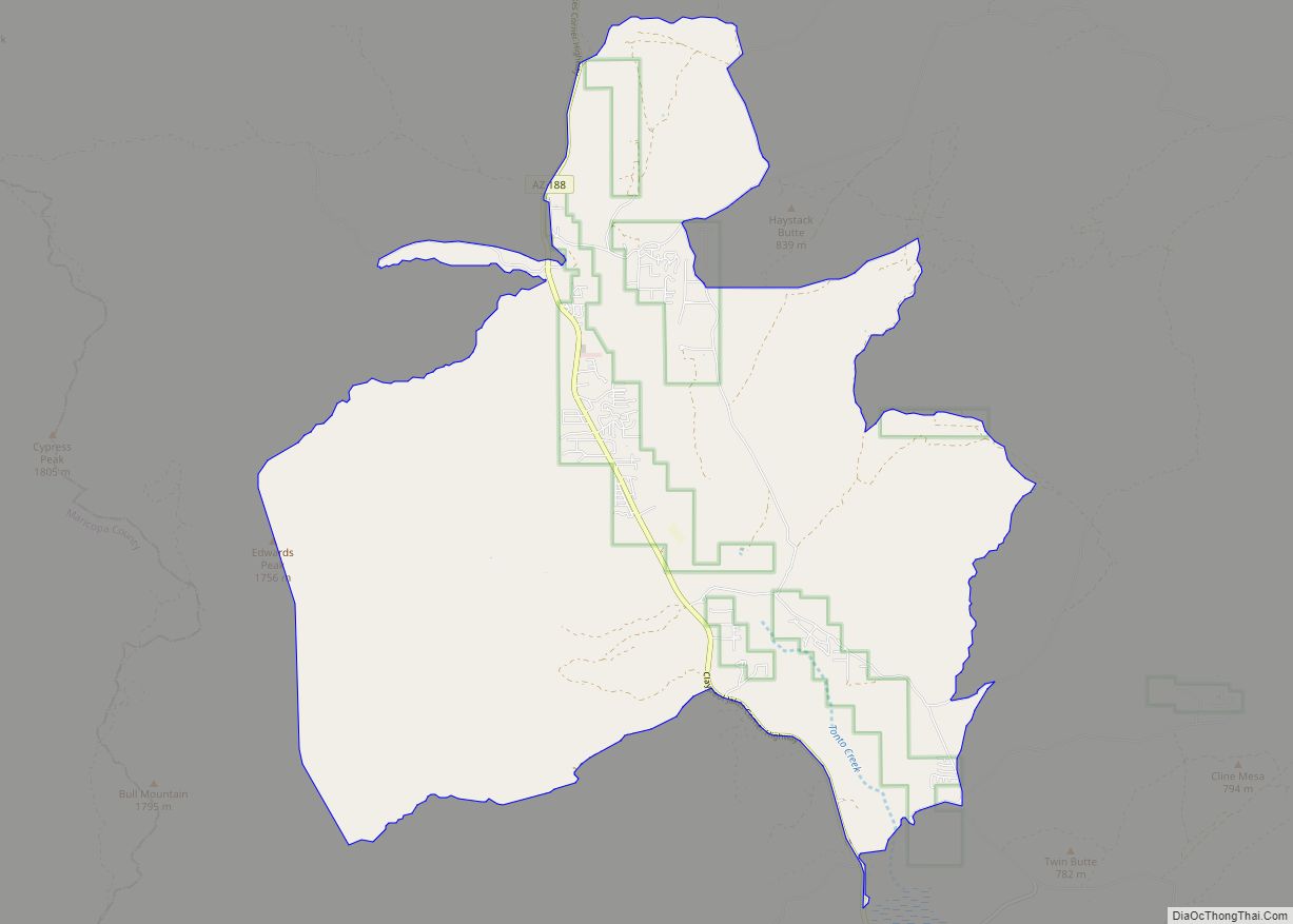
Tonto Basin is a census-designated place (CDP) in Gila County, Arizona, United States. The population was 1,424 at the 2010 United States Census, up from 840 in 2000. Within Tonto Basin is located in the unincorporated community of Punkin Center. Tonto Basin CDP overview: Name: Tonto Basin CDP LSAD Code: 57 LSAD Description: CDP (suffix) … Read more

Map of Toyei CDP

Map of Toyei CDP

Toyei is a census-designated place (CDP) in Apache County, Arizona, United States. The population was 13 at the 2010 census. Toyei CDP overview: Name: Toyei CDP LSAD Code: 57 LSAD Description: CDP (suffix) State: Arizona County: Apache County Elevation: 6,523 ft (1,988 m) Total Area: 0.33 sq mi (0.85 km²) Land Area: 0.33 sq mi (0.84 km²) Water Area: 0.00 sq mi (0.01 km²) Total Population: … Read more

Map of Topock CDP

Map of Topock CDP

Topock (Mojave: Tuupak) (pronounced /’Toe-pock’/ by locals) is a small unincorporated community and census-designated place (CDP) in Mohave County, Arizona, United States. As of the 2020 census, the population within the CDP was 2. Topock and the surrounding region have a ZIP Code of 86436; in 2010, the population of the 86436 ZCTA was 2,104, … Read more

Map of Topawa CDP

Map of Topawa CDP

Topawa (O’odham: name Ḍo Bawui translates as “Gathering Tepary Beans”) is a census-designated place and unincorporated community in Pima County, Arizona, United States. The population was 315 as of the 2020 census. Topawa is located on the Tohono O’odham Nation reservation, 7.5 miles (12.1 km) south-southeast of Sells. Topawa has a post office with ZIP code … Read more

Map of Truxton CDP

Map of Truxton CDP, Arizona

Truxton is an unincorporated community and census-designated place (CDP) in Mohave County, in the U.S. state of Arizona. The population was 104 at the 2020 census, down from 134 in 2010. Truxton CDP overview: Name: Truxton CDP LSAD Code: 57 LSAD Description: CDP (suffix) State: Arizona County: Mohave County Total Area: 3.83 sq mi (9.90 km²) Land Area: … Read more

Map of Tuba City CDP

Map of Tuba City CDP

Tuba City (Navajo: Tó Naneesdizí) is an unincorporated town in Coconino County, Arizona, on the Navajo Nation, United States. It is the second-largest community in Coconino County. The population of the census-designated place (CDP) was 8,611 at the 2010 census. It is the most populous community within the Navajo Nation, slightly larger than Shiprock, New … Read more

Map of Tsaile CDP

Map of Tsaile CDP

Tsaile (Navajo: Tsééhílį́) is a census-designated place (CDP) in Apache County, Arizona, United States, on the Navajo Nation. The population was 1,205 at the 2010 census. Tsaile is the home of the main campus of Diné College (formerly Navajo Community College), a tribally controlled community college. It has seven other campuses across the Navajo Nation. … Read more

Map of Tumacacori-Carmen CDP

Map of Tumacacori-Carmen CDP

Tumacacori (/ˌtuːməˈkɑːkəri/; O’odham: Cemagĭ Gakolig) is an unincorporated community in Santa Cruz County, Arizona, United States, which abuts the community of Carmen. Together, the communities constitute the Tumacacori-Carmen census-designated place (CDP). The population of the CDP was 393 at the 2010 census. Tumacacori-Carmen CDP overview: Name: Tumacacori-Carmen CDP LSAD Code: 57 LSAD Description: CDP (suffix) … Read more

Map of Tucson Estates CDP

Map of Tucson Estates CDP

Tucson Estates is a census-designated place (CDP) in Pima County, Arizona, United States. The population was 9,755 at the 2000 census. Tucson Estates CDP overview: Name: Tucson Estates CDP LSAD Code: 57 LSAD Description: CDP (suffix) State: Arizona County: Pima County Elevation: 2,648 ft (807 m) Total Area: 12.72 sq mi (32.96 km²) Land Area: 12.72 sq mi (32.96 km²) Water Area: 0.00 sq mi … Read more

Map of Tubac CDP

Map of Tubac CDP

Tubac is a census-designated place (CDP) in Santa Cruz County, Arizona, United States. The population was 1,191 at the 2010 census. The place name “Tubac” is an English borrowing from a Hispanicized form of the O’odham name Cuwak, which translates into English as “place of dark water”. When first taken into Spanish speech, it was … Read more

Map of Upper Santan Village CDP

Map of Upper Santan Village CDP

Upper Santan Village is a census-designated place in Pinal County, in the U.S. state of Arizona. The population was 495 at the 2010 census. Upper Santan Village CDP overview: Name: Upper Santan Village CDP LSAD Code: 57 LSAD Description: CDP (suffix) State: Arizona County: Pinal County Total Area: 6.73 sq mi (17.44 km²) Land Area: 6.73 sq mi (17.44 km²) Water … Read more

Map of Tusayan town

Map of Tusayan town

Tusayan is a town, but was a census-designated place during the 2010 census. It is located in Coconino County, Arizona, United States. It was incorporated in 2010. A resort town near the south entrance to Grand Canyon National Park, Tusayan is served by Grand Canyon National Park Airport. The population was 558 at the 2010 … Read more