Map of Garland city

Map of Garland town, Arkansas

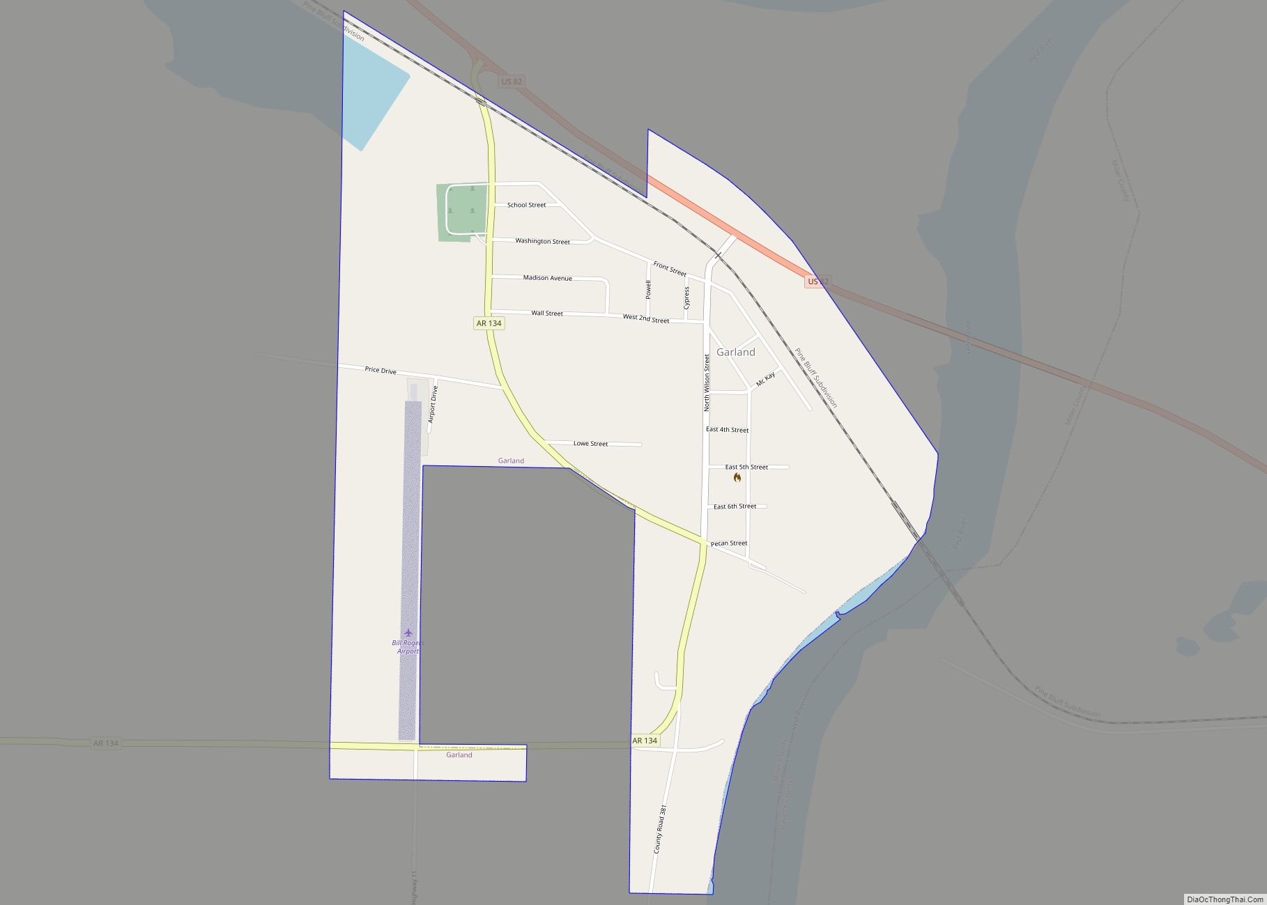
Garland, also known as Garland City, is a town in Miller County, Arkansas, United States. It is part of the Texarkana, Texas – Texarkana, Arkansas Metropolitan Statistical Area. The population was 195 at the 2020 census, down from 242 in 2010. Garland town overview: Name: Garland town LSAD Code: 43 LSAD Description: town (suffix) State: … Read more

Map of Garfield town

Map of Garfield town, Arkansas

Garfield is a town in Benton County, Arkansas, United States. The population was 593 at the 2020 census. It is part of the Northwest Arkansas region. Garfield town overview: Name: Garfield town LSAD Code: 43 LSAD Description: town (suffix) State: Arkansas County: Benton County Elevation: 1,490 ft (450 m) Total Area: 3.09 sq mi (8.01 km²) Land Area: 3.09 sq mi (8.01 km²) … Read more

Map of Gentry city

Map of Gentry city, Arkansas

Gentry is a city in Benton County, Arkansas, United States. The population was 3,790 as of the 2020 census. The city was founded in the Ozark Mountains in 1894 along what would become the Kansas City Southern Railroad. The city’s prior prosperity in the orchard industry, especially apples, was further strengthened by the rail connection. … Read more

Map of Gateway town, Arkansas

Map of Gateway town, Arkansas

Gateway is a town in Benton County, Arkansas, United States. The population was 436 at the 2020 census, up from 405 in 2010. It is part of the Northwest Arkansas region. The town’s name reflects its situation as the “gateway” to and from Arkansas. Gateway town overview: Name: Gateway town LSAD Code: 43 LSAD Description: … Read more

Map of Gassville city

Map of Gassville city

Gassville (formerly Mount Pleasant and Turkey’s Neck) is a city in Baxter County, Arkansas, United States. According to the 2020 census, the city population was 2,171. Gassville city overview: Name: Gassville city LSAD Code: 25 LSAD Description: city (suffix) State: Arkansas County: Baxter County Incorporated: January 20, 1903 Elevation: 742 ft (226 m) Total Area: 3.43 sq mi (8.89 km²) … Read more

Map of Gibson CDP

Map of Gibson CDP, Arkansas

Gibson is a census-designated place (CDP) in Pulaski County, Arkansas, United States. The population was 3,543 at the 2010 census. It is part of the Little Rock–North Little Rock–Conway Metropolitan Statistical Area. Gibson contains the silver deposits that gave North Little Rock its older name of Argenta (derived from the Latin word for silver). Gibson … Read more

Map of Georgetown town

Map of Georgetown town, Arkansas

Georgetown is a town in southeastern White County, Arkansas, United States, overlooking the White River. First settled in 1789 before the Louisiana Purchase, the community is the oldest continuously settled area in Arkansas. Georgetown town overview: Name: Georgetown town LSAD Code: 43 LSAD Description: town (suffix) State: Arkansas County: White County Founded: 1789 Incorporated: 1986 … Read more

Map of Gilbert town

Map of Gilbert town, Arkansas

Gilbert is a town in Searcy County, Arkansas, United States. The population was 26 at the 2020 census, ranking it as the smallest municipality in the state and one of the smallest in the nation. Over the years, Gilbert has gained a reputation (along with Calico Rock) as one of the coldest locations in Arkansas. … Read more

Map of Gilmore city

Map of Gilmore city, Arkansas

Gilmore is a city in Crittenden County, Arkansas, United States. Per the 2020 census, the population was 176. Gilmore city overview: Name: Gilmore city LSAD Code: 25 LSAD Description: city (suffix) State: Arkansas County: Crittenden County Elevation: 223 ft (68 m) Total Area: 13.54 sq mi (35.07 km²) Land Area: 13.52 sq mi (35.01 km²) Water Area: 0.03 sq mi (0.07 km²) Total Population: 176 Population … Read more

Map of Gillham town

Map of Gillham town

Gillham is a town in Sevier County, Arkansas, United States. The population was 188 at the 2000 census. It is located six miles from Gillham Lake. Gillham town overview: Name: Gillham town LSAD Code: 43 LSAD Description: town (suffix) State: Arkansas County: Sevier County Elevation: 742 ft (226 m) Total Area: 0.93 sq mi (2.42 km²) Land Area: 0.92 sq mi (2.38 km²) … Read more

Map of Gillett city

Map of Gillett city, Arkansas

Gillett is a city in Arkansas County, Arkansas, United States. Its population was 691 at the 2010 census. Gillett is the home of the annual Gillett Coon Supper. The Arkansas Post National Memorial is located southeast of the town. The largest alligator ever killed in Arkansas was harpooned near Gillett on September 19, 2010. The … Read more

Map of Gosnell city

Map of Gosnell city

Gosnell is a city in northern Mississippi County, Arkansas, United States. The population was 2,910 at the 2020 census, down from 3,548 at the 2010 census. Gosnell city overview: Name: Gosnell city LSAD Code: 25 LSAD Description: city (suffix) State: Arkansas County: Mississippi County Elevation: 243 ft (74 m) Total Area: 1.61 sq mi (4.18 km²) Land Area: 1.61 sq mi (4.18 km²) … Read more