Map of Hensley CDP

Map of Hensley CDP

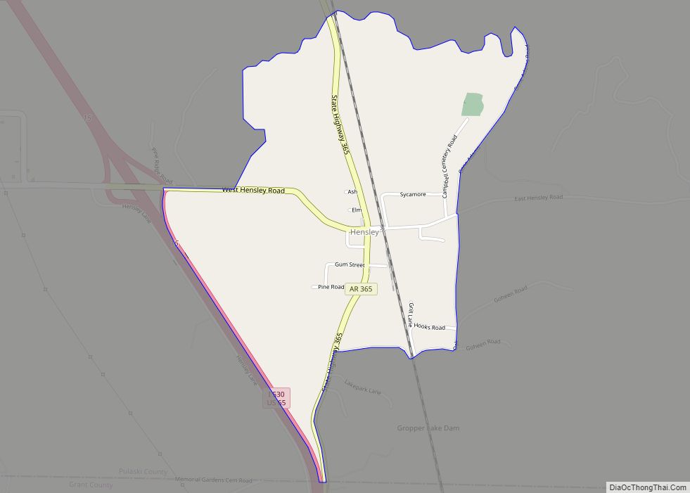
Hensley is a census-designated place (CDP) in Pulaski County, Arkansas, United States. The population was 139 at the 2010 census. It is part of the Little Rock–North Little Rock–Conway Metropolitan Statistical Area. Hensley CDP overview: Name: Hensley CDP LSAD Code: 57 LSAD Description: CDP (suffix) State: Arkansas County: Pulaski County Founded: January 27, 1882(141 years ago) (1882-01-27) … Read more

Map of Helena-West Helena city

Map of Helena-West Helena city

Helena–West Helena is the county seat of and the largest city within Phillips County, Arkansas, United States. The current city was consolidated, effective January 1, 2006, from the two Arkansas cities of Helena and West Helena. Helena is sited on lowlands between the Mississippi River and the eastern side of Crowley’s Ridge. West Helena is … Read more

Map of Hickory Ridge city

Map of Hickory Ridge city

Hickory Ridge is a city in Cross County, Arkansas, United States. The population was 272 at the 2010 census. Always a small farming community with an economy based on agriculture, a post office was first established in 1875, but the community did not incorporate until 1949. Hickory Ridge city overview: Name: Hickory Ridge city LSAD … Read more

Map of Higginson town

Map of Higginson town

Higginson is a second-class city in White County, Arkansas, United States. Randall Homsley is the current mayor and was a volunteer police officer until the volunteer police force was disbanded. The population was 621 at the 2010 census. Higginson town overview: Name: Higginson town LSAD Code: 43 LSAD Description: town (suffix) State: Arkansas County: White … Read more

Map of Higden town

Map of Higden town

Higden is a town in Cleburne County, Arkansas, United States. The population was 120 at the 2010 census. Scott Barker is the current Mayor of Higden Higden town overview: Name: Higden town LSAD Code: 43 LSAD Description: town (suffix) State: Arkansas County: Cleburne County Elevation: 525 ft (160 m) Total Area: 0.49 sq mi (1.26 km²) Land Area: 0.48 sq mi (1.26 km²) … Read more

Map of Hindsville town

Map of Hindsville town

Hindsville is a town in Madison County, Arkansas, United States. The population was 90 at the 2020 census. It is part of the Northwest Arkansas region. The community was named after John Hinds, a first settler. Hindsville town overview: Name: Hindsville town LSAD Code: 43 LSAD Description: town (suffix) State: Arkansas County: Madison County Elevation: … Read more

Map of Highland city

Map of Highland city, Arkansas

Highland is a city in Sharp County, Arkansas, United States. The city was incorporated in 1998 and is located in Sharp County. It is the fourth largest city in Sharp County with a population of 1,015 in 2021 Highland city overview: Name: Highland city LSAD Code: 25 LSAD Description: city (suffix) State: Arkansas County: Sharp … Read more

Map of Highfill town

Map of Highfill town

Highfill is a town in Benton County, Arkansas, United States. The population was 1,587 as of the 2020 census. It is home to the Northwest Arkansas National Airport, which serves all of the Northwest Arkansas region. Highfill town overview: Name: Highfill town LSAD Code: 43 LSAD Description: town (suffix) State: Arkansas County: Benton County Elevation: … Read more

Map of Holly Grove city

Map of Holly Grove city

Holly Grove is a city in Monroe County, Arkansas, United States. As of the 2020 census, the city population was 460, down from 602 in 2010. Holly Grove city overview: Name: Holly Grove city LSAD Code: 25 LSAD Description: city (suffix) State: Arkansas County: Monroe County Elevation: 180 ft (50 m) Total Area: 1.02 sq mi (2.64 km²) Land Area: … Read more

Map of Holland city

Map of Holland city, Arkansas

Holland is a city in Faulkner County, Arkansas, United States. The population was 557 at the 2010 census. It is part of the Little Rock–North Little Rock–Conway Metropolitan Statistical Area. Holland gained media attention after 13-year-old Kacie Woody was reported missing from her home in this area in 2002; an investigation revealed that she was … Read more

Map of Holiday Island CDP

Map of Holiday Island CDP

Holiday Island is a 4,500-acre planned retirement and vacation community in Carroll County, Arkansas, United States. Formerly an unincorporated community and census-designated place (CDP), they voted to incorporate in November 2020. As of the 2020 census, the population was 2,533. Holiday Island is located in the Ozark Mountains on Table Rock Lake near Eureka Springs, … Read more

Map of Horseshoe Bend city

Map of Horseshoe Bend city, Arkansas

Horseshoe Bend is a city in Fulton, Izard, and Sharp counties in the U.S. state of Arkansas. The population was 2,184 at the 2010 census. It is named for the large loop or horseshoe bend in the nearby Strawberry River. Horseshoe Bend city overview: Name: Horseshoe Bend city LSAD Code: 25 LSAD Description: city (suffix) … Read more