Map of Warren city

Map of Warren city, Arkansas

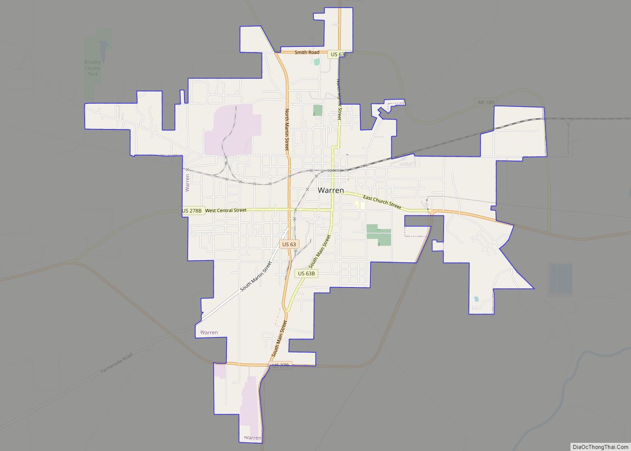
Warren is a city in and the county seat of Bradley County, Arkansas, United States. As of the 2010 census, the population was 6,003. Warren city overview: Name: Warren city LSAD Code: 25 LSAD Description: city (suffix) State: Arkansas County: Bradley County Elevation: 220 ft (67 m) Total Area: 7.06 sq mi (18.28 km²) Land Area: 7.04 sq mi (18.22 km²) Water Area: … Read more

Map of Ward city

Map of Ward city, Arkansas

Ward is the third most populous city in Lonoke County, Arkansas, United States. The population was 4,067 at the 2010 census. It is part of the Little Rock–North Little Rock–Conway Metropolitan Statistical Area. Ward city overview: Name: Ward city LSAD Code: 25 LSAD Description: city (suffix) State: Arkansas County: Lonoke County Elevation: 240 ft (73 m) Total … Read more

Map of Weldon town

Map of Weldon town, Arkansas

Weldon is a town in Jackson County, Arkansas, United States. The population was 75 at the 2010 census. Weldon town overview: Name: Weldon town LSAD Code: 43 LSAD Description: town (suffix) State: Arkansas County: Jackson County Elevation: 223 ft (68 m) Total Area: 0.24 sq mi (0.63 km²) Land Area: 0.24 sq mi (0.63 km²) Water Area: 0.00 sq mi (0.00 km²) Total Population: 57 Population … Read more

Map of Weiner city

Map of Weiner city

Weiner is a city in Poinsett County, Arkansas, United States. The population was 716 at the 2010 census. It is included in the Jonesboro, Arkansas Metropolitan Statistical Area. Weiner city overview: Name: Weiner city LSAD Code: 25 LSAD Description: city (suffix) State: Arkansas County: Poinsett County Elevation: 246 ft (75 m) Total Area: 1.36 sq mi (3.53 km²) Land Area: … Read more

Map of Watson city

Map of Watson city, Arkansas

Watson is a city in Desha County, Arkansas, United States. The population was 211 at the 2010 census. Watson city overview: Name: Watson city LSAD Code: 25 LSAD Description: city (suffix) State: Arkansas County: Desha County Elevation: 148 ft (45 m) Total Area: 0.20 sq mi (0.52 km²) Land Area: 0.20 sq mi (0.52 km²) Water Area: 0.00 sq mi (0.00 km²) Total Population: 185 Population … Read more

Map of West Fork city

Map of West Fork city

West Fork is a city in Washington County, Arkansas, United States. The population is 2,331 at the 2020 census. It is part of the Northwest Arkansas region. West Fork city overview: Name: West Fork city LSAD Code: 25 LSAD Description: city (suffix) State: Arkansas County: Washington County Founded: 1848 Incorporated: May 18, 1885 Elevation: 1,362 ft … Read more

Map of West Crossett CDP

Map of West Crossett CDP

West Crossett is a census-designated place (CDP) in Ashley County, Arkansas, United States. Per the 2020 census, the population was 1,144. West Crossett CDP overview: Name: West Crossett CDP LSAD Code: 57 LSAD Description: CDP (suffix) State: Arkansas County: Ashley County Elevation: 151 ft (46 m) Total Area: 11.90 sq mi (30.83 km²) Land Area: 11.89 sq mi (30.80 km²) Water Area: 0.01 sq mi … Read more

Map of West Memphis city

Map of West Memphis city

West Memphis is the largest city in Crittenden County, Arkansas, United States. The population was 26,245 at the 2010 census, ranking it as the state’s 18th largest city, behind Bella Vista. It is part of the Memphis metropolitan area, and is located directly across the Mississippi River from Memphis, Tennessee. West Memphis city overview: Name: … Read more

Map of Wheatley city

Map of Wheatley city

Wheatley is a town in southwest St. Francis County, Arkansas, United States. The population was 279 at the 2020 census, down from 355 in 2010. Wheatley city overview: Name: Wheatley city LSAD Code: 25 LSAD Description: city (suffix) State: Arkansas County: St. Francis County Elevation: 207 ft (63 m) Total Area: 3.07 sq mi (7.95 km²) Land Area: 3.07 sq mi (7.95 km²) … Read more

Map of Western Grove town

Map of Western Grove town

Western Grove is a town in northeastern Newton County, Arkansas, United States. The population was 384 at the 2010 census. It is part of the Harrison Micropolitan Statistical Area. Western Grove town overview: Name: Western Grove town LSAD Code: 43 LSAD Description: town (suffix) State: Arkansas County: Newton County Elevation: 1,050 ft (320 m) Total Area: 1.08 sq mi … Read more

Map of West Point town, Arkansas

Map of West Point town, Arkansas

West Point is a town in White County, Arkansas, United States. David Hamilton was mayor from “1972 except for two years he missed for cancer surgery,” according to an article in the Searcy, Arkansas newspaper The Daily Citizen (“Mayors bring politics, leadership to ground level” by Warren Watkins, 27 January 2007). “My great-grandfather landed at … Read more

Map of Wickes town

Map of Wickes town

Wickes is a city in Polk County, Arkansas, United States. The population was 754 at the 2010 census. Near Wickes is the Boggs Springs Youth Encampment of the American Baptist Association, a retreat of Missionary Baptist churches. Wickes has historic places such as the 100-year-old City Hall, and the Lighthouse Drive-in. Wickes town overview: Name: … Read more