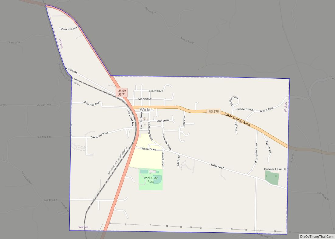
Map of White Hall city, Arkansas

Map of White Hall city, Arkansas

White Hall is a city in Washington Township, located in Jefferson County, Arkansas, United States. With a population of 5,526 in the 2010 census, it is included in the Pine Bluff Metropolitan Statistical Area and the greater Little Rock-North Little Rock-Pine Bluff Combined Statistical Area. White Hall is home to the Pine Bluff Arsenal. White … Read more

Map of Whelen Springs town

Map of Whelen Springs town

Whelen Springs is a town in Clark County, Arkansas, United States. The population was 92 at the 2010 census. From 1930 through 1939 the town thrived, being a main hub of operations for the then powerful Ozan Lumber Company. Whelen Springs town overview: Name: Whelen Springs town LSAD Code: 43 LSAD Description: town (suffix) State: … Read more

Map of Williford town

Map of Williford town

Williford is a town in Sharp County, Arkansas, United States. The population was 70 in 2020 Williford town overview: Name: Williford town LSAD Code: 43 LSAD Description: town (suffix) State: Arkansas County: Sharp County Elevation: 331 ft (101 m) Total Area: 0.35 sq mi (0.91 km²) Land Area: 0.35 sq mi (0.91 km²) Water Area: 0.00 sq mi (0.00 km²) Total Population: 79 Population Density: 226.36/sq mi … Read more

Map of Wiederkehr Village city

Map of Wiederkehr Village city

Wiederkehr Village is a city in Franklin County, Arkansas, United States. It is part of the Fort Smith, Arkansas–Oklahoma Metropolitan Statistical Area. The population was 38 at the 2010 census. It is named after Swiss winemaker Johann Andreas Wiederkehr, who immigrated to the area in 1880. Wiederkehr Village city overview: Name: Wiederkehr Village city LSAD … Read more

Map of Widener town

Map of Widener town

Widener is a town in St. Francis County, Arkansas, United States. The population was 212 at the 2020 census, a decline from 273 in 2010. Widener town overview: Name: Widener town LSAD Code: 43 LSAD Description: town (suffix) State: Arkansas County: St. Francis County Elevation: 207 ft (63 m) Total Area: 0.55 sq mi (1.41 km²) Land Area: 0.55 sq mi (1.41 km²) … Read more

Map of Wilmot city

Map of Wilmot city, Arkansas

Wilmot is a city in Ashley County, Arkansas, United States. The population was 550 at the 2010 census. Wilmot city overview: Name: Wilmot city LSAD Code: 25 LSAD Description: city (suffix) State: Arkansas County: Ashley County Elevation: 108 ft (33 m) Total Area: 1.77 sq mi (4.59 km²) Land Area: 1.77 sq mi (4.58 km²) Water Area: 0.01 sq mi (0.01 km²) Total Population: 416 Population … Read more

Map of Wilmar city

Map of Wilmar city

Wilmar is a city in Drew County, Arkansas, United States. The population was 511 at the 2010 census, down from 571 in 2000. Wilmar city overview: Name: Wilmar city LSAD Code: 25 LSAD Description: city (suffix) State: Arkansas County: Drew County Elevation: 154 ft (47 m) Total Area: 1.53 sq mi (3.98 km²) Land Area: 1.53 sq mi (3.98 km²) Water Area: 0.00 sq mi … Read more

Map of Willisville town

Map of Willisville town, Arkansas

Willisville is a town in Nevada County, Arkansas, United States. The population was 148 at the 2020 census. It is part of the Hope Micropolitan Statistical Area. Willisville town overview: Name: Willisville town LSAD Code: 43 LSAD Description: town (suffix) State: Arkansas County: Nevada County Elevation: 361 ft (110 m) Total Area: 1.61 sq mi (4.17 km²) Land Area: 1.60 sq mi … Read more

Map of Winchester town

Map of Winchester town, Arkansas

Winchester is a small town in northeast Drew County, Arkansas, United States. The population was 167 at the 2010 census, declining from its 20th-century high of 279 in 1980. Winchester town overview: Name: Winchester town LSAD Code: 43 LSAD Description: town (suffix) State: Arkansas County: Drew County Elevation: 154 ft (47 m) Total Area: 0.50 sq mi (1.29 km²) Land … Read more

Map of Wilton city, Arkansas

Map of Wilton city, Arkansas

Wilton is a city in Little River County, Arkansas, United States. The population was 374 at the 2010 census, down from 439 at the 2000 census. Wilton city overview: Name: Wilton city LSAD Code: 25 LSAD Description: city (suffix) State: Arkansas County: Little River County Elevation: 318 ft (97 m) Total Area: 1.28 sq mi (3.31 km²) Land Area: 1.28 sq mi … Read more

Map of Wilson city

Map of Wilson city, Arkansas

Wilson is a city in Mississippi County, Arkansas, United States. The community is located in the Arkansas Delta and is surrounded by fertile cropland historically used to produce cotton. Wilson started as a company town in 1886 by Robert E. Lee Wilson, who would build a cotton empire and run it from the city. The … Read more

Map of Woodlawn CDP

Map of Woodlawn CDP, Arkansas

Woodlawn is a census-designated place in Cleveland County, Arkansas, United States. Per the 2020 census, the population was 174. Woodlawn CDP overview: Name: Woodlawn CDP LSAD Code: 57 LSAD Description: CDP (suffix) State: Arkansas County: Cleveland County Elevation: 259 ft (79 m) Total Area: 2.35 sq mi (6.09 km²) Land Area: 2.35 sq mi (6.09 km²) Water Area: 0.00 sq mi (0.00 km²) Total Population: 174 … Read more