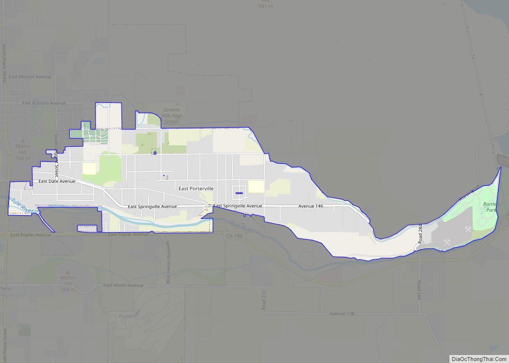
Map of East Shore CDP

Map of East Shore CDP

East Shore is a census-designated place (CDP) in Plumas County, California, United States. The population was 156 at the 2010 census, down from 177 at the 2000 census. East Shore CDP overview: Name: East Shore CDP LSAD Code: 57 LSAD Description: CDP (suffix) State: California County: Plumas County Elevation: 4,518 ft (1,377 m) Total Area: 1.183 sq mi (3.064 km²) … Read more

Map of East San Gabriel CDP

Map of East San Gabriel CDP

East San Gabriel is a census-designated place (CDP) in Los Angeles County, California, United States. The population was 14,874 at the 2010 census, up from 14,512 at the 2000 census. East San Gabriel CDP overview: Name: East San Gabriel CDP LSAD Code: 57 LSAD Description: CDP (suffix) State: California County: Los Angeles County Elevation: 377 ft … Read more

Map of East Richmond Heights CDP

Map of East Richmond Heights CDP

East Richmond Heights is an unincorporated community and census-designated place (CDP) in western Contra Costa County, California, United States. Its population was 3,280 at the 2010 census. East Richmond Heights CDP overview: Name: East Richmond Heights CDP LSAD Code: 57 LSAD Description: CDP (suffix) State: California County: Contra Costa County Elevation: 387 ft (118 m) Total Area: … Read more

Map of East Tulare Villa CDP

Map of East Tulare Villa CDP

East Tulare Villa is a census-designated place (CDP) in Tulare County, California. East Tulare Villa sits at an elevation of 302 feet (92 m). The 2010 United States census reported East Tulare Villa’s population was 778. East Tulare Villa CDP overview: Name: East Tulare Villa CDP LSAD Code: 57 LSAD Description: CDP (suffix) State: California County: … Read more

Map of East Sonora CDP

Map of East Sonora CDP

East Sonora is a census-designated place (CDP) in Tuolumne County, California, United States. The population was 2,266 at the 2010 census, up from 2,078 at the 2000 census. East Sonora CDP overview: Name: East Sonora CDP LSAD Code: 57 LSAD Description: CDP (suffix) State: California County: Tuolumne County Elevation: 2,106 ft (642 m) Total Area: 2.481 sq mi (6.425 km²) … Read more

Map of East Whittier CDP

Map of East Whittier CDP

East Whittier (pronunciation) is an unincorporated community in Los Angeles County, California, United States. The population was 9,757 at the 2010 census, up from 9,538 at the 2000 census. For statistical purposes, the United States Census Bureau has defined this community as a census-designated place (CDP). The name was changed from East La Mirada in … Read more

Map of Edgewood CDP

Map of Edgewood CDP, California

Edgewood is a census-designated place (CDP) in Siskiyou County, California, United States. Its population is 72 as of the 2020 census, up from 43 from the 2010 census. Edgewood is located three miles north of the town of Weed. Edgewood CDP overview: Name: Edgewood CDP LSAD Code: 57 LSAD Description: CDP (suffix) State: California County: … Read more

Map of Eastvale city

Map of Eastvale city, California

Eastvale is a city located in northwestern Riverside County, California, in the Inland Empire region of Southern California. The area transitioned from a dairy farm enclave to a developed community starting in the 1990s and was formally incorporated on October 1, 2010. As of the 2020 census, the city had a population of 69,757. The … Read more

Map of Easton CDP

Map of Easton CDP, California

Easton (formerly, Covel and Covell) is a census-designated place (CDP) in Fresno County, California, United States. The population was 2,083 at the 2010 census, up from 1,966 at the 2000 census. Easton is located 7.5 miles (12.1 km) south of downtown Fresno, at an elevation of 276 feet (84 m). Easton CDP overview: Name: Easton CDP … Read more

Map of Edwards AFB CDP

Map of Edwards AFB CDP

Edwards AFB CDP overview: Name: Edwards AFB CDP LSAD Code: 57 LSAD Description: CDP (suffix) State: California County: Kern County FIPS code: 0621600 Online Interactive Map Edwards AFB online map. Source: Basemap layers from Google Map, Open Street Map (OSM), Arcgisonline, Wmflabs. Boundary Data from Database of Global Administrative Areas. Edwards AFB location map. Where … Read more

Map of Edna CDP

Map of Edna CDP, California

Edna is a census-designated place in San Luis Obispo County, California. Edna is at an elevation of around 266 feet (81 m). The 2010 United States census reported Edna’s population was 193. It is best known for the wine industry in the Edna Valley AVA. Edna CDP overview: Name: Edna CDP LSAD Code: 57 LSAD Description: … Read more

Map of Edmundson Acres CDP

Map of Edmundson Acres CDP

Edmundson Acres is a census-designated place in Kern County, California. It is located 1.25 miles (2 km) north-northeast of Arvin, at an elevation of 486 feet (148 m). Edmundson Acres’ ZIP code is 93203. The population was 279 at the 2010 census. Edmundson Acres CDP overview: Name: Edmundson Acres CDP LSAD Code: 57 LSAD Description: CDP (suffix) … Read more