Map of Glen St. Mary town

Map of Glen St. Mary town

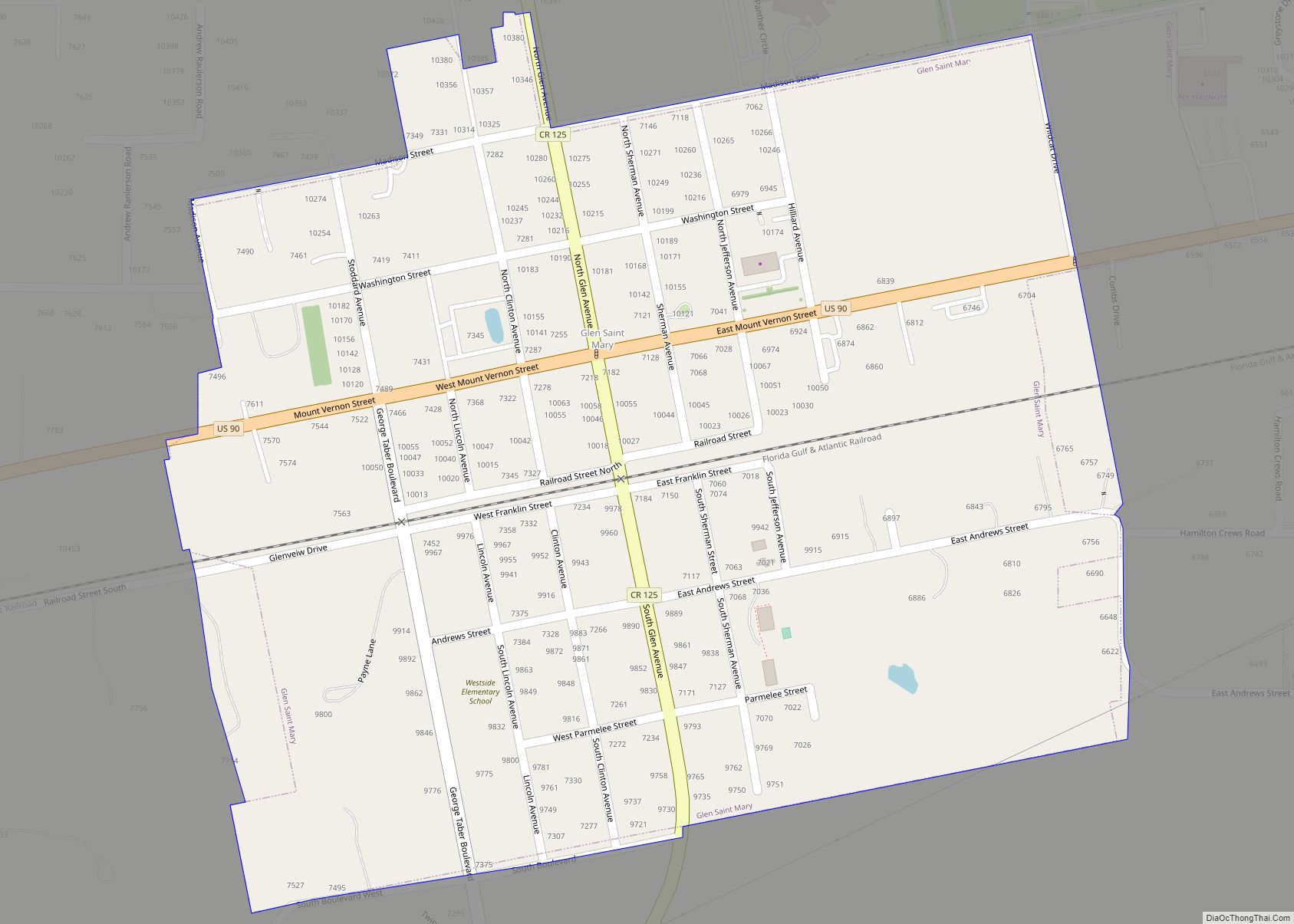
Glen St. Mary is a town in Baker County, Florida, United States. In 2010, the population recorded by the U.S. Census Bureau was 437. Glen St. Mary town overview: Name: Glen St. Mary town LSAD Code: 43 LSAD Description: town (suffix) State: Florida County: Baker County Elevation: 131 ft (40 m) Total Area: 0.46 sq mi (1.19 km²) Land Area: … Read more

Map of Glen Ridge town

Map of Glen Ridge town, Florida

Glen Ridge is a town in Palm Beach County, Florida, United States. The population was 219 at the 2010 census. As of 2018, the population recorded by the U.S. Census Bureau was 243. Glen Ridge town overview: Name: Glen Ridge town LSAD Code: 43 LSAD Description: town (suffix) State: Florida County: Palm Beach County Elevation: … Read more

Map of Gladeview CDP

Map of Gladeview CDP

Gladeview is a census-designated place (CDP) in Miami-Dade County, Florida, United States. The population was 14,927 at the 2020 census, up from 11,535 in 2010. Gladeview was originally a neighborhood of the city of Miami when it was annexed in 1925. With the arrival of the Great Depression, Miami gave up its jurisdiction and Gladeview … Read more

Map of Golden Beach town

Map of Golden Beach town, Florida

Golden Beach is a town in Miami-Dade County, Florida, United States, between the Intracoastal Waterway and Atlantic Ocean. As of the 2020 census, the town had a population of 961. Golden Beach town overview: Name: Golden Beach town LSAD Code: 43 LSAD Description: town (suffix) State: Florida County: Miami-Dade County Incorporated: May 23, 1929 Elevation: … Read more

Map of Glenvar Heights CDP

Map of Glenvar Heights CDP

Glenvar Heights is a census-designated place (CDP) and neighborhood in Miami-Dade County, Florida, United States. The population was 20,786 at the 2020 census, up from 16,898 in 2010. The community is served by the Miami ZIP codes 33143 and 33155. Glenvar Heights CDP overview: Name: Glenvar Heights CDP LSAD Code: 57 LSAD Description: CDP (suffix) … Read more

Map of Glencoe CDP, Florida

Map of Glencoe CDP, Florida

Glencoe is a census-designated place (CDP) in Volusia County, Florida, United States. The population was 2,582 at the 2010 census. Glencoe CDP overview: Name: Glencoe CDP LSAD Code: 57 LSAD Description: CDP (suffix) State: Florida County: Volusia County Elevation: 20 ft (6 m) Total Area: 3.47 sq mi (8.99 km²) Land Area: 3.47 sq mi (8.99 km²) Water Area: 0.00 sq mi (0.00 km²) Total Population: … Read more

Map of Goldenrod CDP

Map of Goldenrod CDP

Goldenrod is a census-designated place (CDP) in Orange and Seminole counties in the U.S. state of Florida. The population was 12,039 at the 2010 census. It is part of the Orlando–Kissimmee–Sanford, Florida Metropolitan Statistical Area. Goldenrod CDP overview: Name: Goldenrod CDP LSAD Code: 57 LSAD Description: CDP (suffix) State: Florida County: Orange County, Seminole County … Read more

Map of Golden Glades CDP

Map of Golden Glades CDP

Golden Glades is a census-designated place (CDP) in Miami-Dade County, Florida, United States. The population was 32,499 at the 2020 census. It is the location for a Golden Glades Interchange which connects the Florida Turnpike, Interstate 95, US 441, State Road 9, and the Palmetto Expressway. Golden Glades CDP overview: Name: Golden Glades CDP LSAD … Read more

Map of Golden Gate CDP

Map of Golden Gate CDP, Florida

Golden Gate is a community and census-designated place (CDP) in Collier County, Florida, United States. Golden Gate’s boundaries coincide with a 2 by 2 miles (3.2 by 3.2 km) square of significantly higher density development than surrounding areas. The population was 23,961 as recorded in the 2010 census. It is part of the Naples–Marco Island Metropolitan … Read more

Map of Goodland CDP

Map of Goodland CDP, Florida

Goodland is a census-designated place (CDP) in Collier County, Florida, United States. The population was 267 at the 2010 census. It is part of the Naples–Marco Island Metropolitan Statistical Area. Located on the southeast portion of Marco Island, it is the closest community to Cape Romano, the southern tip of a nearby island that was … Read more

Map of Gonzalez CDP

Map of Gonzalez CDP

Gonzalez is a census-designated place (CDP) in Escambia County, Florida. Gonzalez is located north of Pensacola, and is considered to be within Cantonment. Tate High School, the largest public school in Escambia County, is located in the Gonzalez area. As of the 2020 United States Census, the population was 14,586. Gonzalez CDP overview: Name: Gonzalez … Read more

Map of Golf village

Map of Golf village, Florida

The Village of Golf is a village in Palm Beach County, Florida, United States. As of 2018, the population recorded by the U.S. Census Bureau was 275. Golf village overview: Name: Golf village LSAD Code: 47 LSAD Description: village (suffix) State: Florida County: Palm Beach County Elevation: 13 ft (4 m) Total Area: 0.83 sq mi (2.15 km²) Land Area: … Read more