Map of Kualapuu CDP

Map of Kualapuu CDP

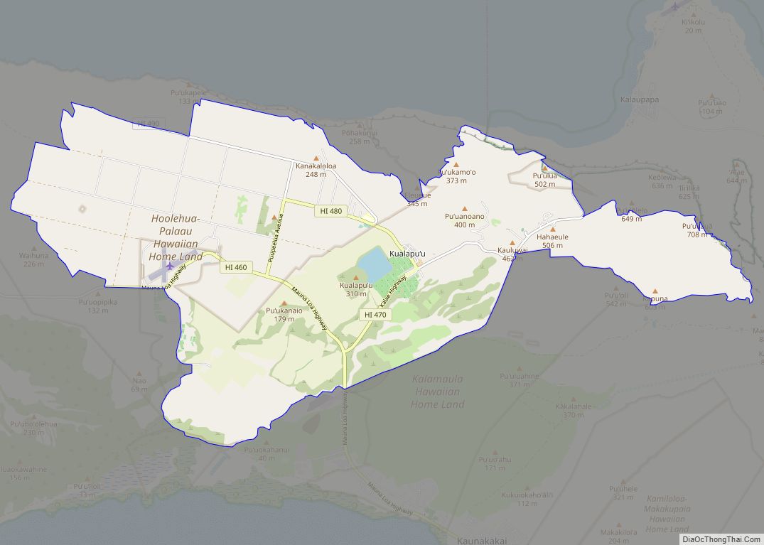
Kualapuʻu is a census-designated place (CDP) on the island of Molokai in Maui County, Hawaiʻi, United States. The population was 2,110 at the 2020 census. Kualapuʻu can be literally translated as “hill overturned”, but is thought to be a corruption of Puʻuʻuala: “sweet potato hill”. The present settlement is a former pineapple cannery village once … Read more

Map of Koloa CDP

Map of Koloa CDP

Kōloa is an unincorporated community and census-designated place (CDP) in Kauaʻi County, Hawaiʻi, United States. The population was 2,231 at the 2020 census, up from 1,942 at the 2000 census. The first successful sugarcane plantation in the Hawaiian Islands was started here in 1835. It became a part of Grove Farm in 1948. The name … Read more

Map of Kula CDP

Map of Kula CDP

Kula is a district and census-designated place (CDP) of Maui, Hawaii, that stretches across the “up-country”, the western-facing slopes of Haleakalā, from Makawao to Kanaio. Most of the residential areas lie between about 500 to 1,100 m (1,600 to 3,600 ft) in elevation. The district has traditionally been where full-time residents prefer to live, as distinct from … Read more

Map of Lahaina CDP

Map of Lahaina CDP

Lahaina (Hawaiian: Lāhainā) is the largest census-designated place (CDP) in West Maui, Maui County, Hawaii, United States and includes the Kaanapali and Kapalua beach resorts. As of the 2020 census, the CDP had a resident population of 12,702. Lahaina encompasses the coast along Hawaii Route 30 from a tunnel at the south end, through Olowalu … Read more

Map of Kurtistown CDP

Map of Kurtistown CDP

Kurtistown is a census-designated place (CDP) in Hawaiʻi County, Hawaiʻi, United States, in the District of Puna. The population was 1,298 at the 2010 census, up from 1,157 at the 2000 census. Kurtistown CDP overview: Name: Kurtistown CDP LSAD Code: 57 LSAD Description: CDP (suffix) State: Hawaii County: Hawaii County Elevation: 633 ft (193 m) Total Area: … Read more

Map of Launiupoko CDP

Map of Launiupoko CDP

Launiupoko is an unincorporated community and census-designated place on the island of Maui in Maui County, Hawaii, United States. Its population stands at 688 as of the 2020 census. The community is located on the west side of the island. Launiupoko Beach Park is located near the beach in the community, managed by the county … Read more

Map of Lanai City CDP

Map of Lanai City CDP

Lāna‘i City is a census-designated place (CDP) on the island of Lāna‘i, in Maui County, Hawai‘i, United States. The population was 3,332 at the 2020 census. Lāna‘i City is the island’s commercial center. Many of the island’s restaurants and shops are in the town square that surrounds Dole Park, and the only hospital on the … Read more

Map of Laie CDP

Map of Laie CDP

Laie (Hawaiian: Lāʻie, pronounced [laːˈʔie]) is a census-designated place (CDP) located in the Koolauloa District on the island of Oahu (Oʻahu) in Honolulu County, Hawaii, United States. In Hawaiian, lāʻie means “ʻie leaf” (ʻieʻie is a climbing screwpine: Freycinetia arborea). The population was 5,963 at the 2020 census. Laie CDP overview: Name: Laie CDP LSAD Code: … Read more

Map of Leilani Estates CDP

Map of Leilani Estates CDP

Leilani Estates is a census-designated place (CDP) in Hawaiʻi County, Hawaii, United States located in the District of Puna. The subdivision was formed in 1964. The population was 1,139 at the 2020 census, down from 1,560 at the 2010 census, and up from 1,046 at the 2000 census. The 2018 lower Puna eruption of Kīlauea … Read more

Map of Lawai CDP

Map of Lawai CDP

Lāwaʻi is a census-designated place (CDP) in Kauaʻi County in the U.S. state of Hawaiʻi. The population was 2,578 at the 2020 census, up from 1,984 at the 2000 census. Lawai CDP overview: Name: Lawai CDP LSAD Code: 57 LSAD Description: CDP (suffix) State: Hawaii County: Kauai County Elevation: 554 ft (169 m) Total Area: 4.15 sq mi (10.75 km²) … Read more

Map of Laupahoehoe CDP

Map of Laupahoehoe CDP

Laupāhoehoe is a census-designated place (CDP) in Hawaiʻi County, Hawaii, United States, in the District of North Hilo. The population was 581 at the 2010 census, up from 473 at the 2000 census. The community’s name means “lava tip” and refers to the angular lava tip or cape formed by ancient pāhoehoe (smooth lava) flows … Read more

Map of Mahinahina CDP

Map of Mahinahina CDP

Mahinahina is an unincorporated community and census-designated place on the island of Maui in Maui County, Hawaii, United States. Its population was 910 as of the 2020 census. The community is located on the west side of the island. Mahinahina CDP overview: Name: Mahinahina CDP LSAD Code: 57 LSAD Description: CDP (suffix) State: Hawaii County: … Read more