Map of Wauconda village

Map of Wauconda village

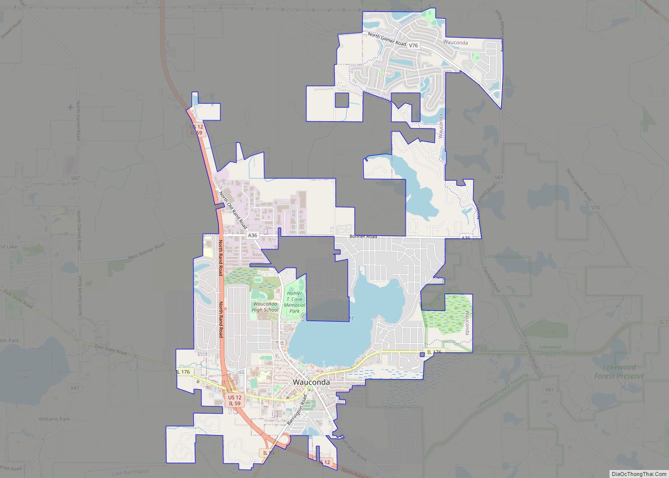
Wauconda (/ˌwɔːˈkɒndə/ or /wəˈkɒndə/) is a village in Lake County, Illinois, United States. Per the 2020 census, the population was 14,084. It is the site of the Wauconda Bog Nature Preserve, a National Natural Landmark. Wauconda Community Unit School District 118 serves students from Pre-K through 12th grade who live in Wauconda and surrounding communities … Read more

Map of Wayne City village

Map of Wayne City village

Wayne City is a village in Wayne County, Illinois, United States. The population was 994 at the 2020 census. Wayne City village overview: Name: Wayne City village LSAD Code: 47 LSAD Description: village (suffix) State: Illinois County: Wayne County Elevation: 453 ft (138 m) Total Area: 1.74 sq mi (4.51 km²) Land Area: 1.73 sq mi (4.48 km²) Water Area: 0.01 sq mi (0.03 km²) Total … Read more

Map of Waverly city, Illinois

Map of Waverly city, Illinois

Waverly, founded in 1836, is the second largest city in Morgan County, Illinois, United States. The population was 1,194 at the 2020 census. It is part of the Jacksonville Micropolitan Statistical Area. The town was named after the Waverley novels of Sir Walter Scott. Waverly city overview: Name: Waverly city LSAD Code: 25 LSAD Description: … Read more

Map of Waynesville village

Map of Waynesville village, Illinois

Waynesville is a village in DeWitt County, Illinois, United States. The population was 381 at the 2020 census. Waynesville village overview: Name: Waynesville village LSAD Code: 47 LSAD Description: village (suffix) State: Illinois County: De Witt County Elevation: 725 ft (221 m) Total Area: 0.32 sq mi (0.83 km²) Land Area: 0.32 sq mi (0.83 km²) Water Area: 0.00 sq mi (0.00 km²) Total Population: 381 … Read more

Map of Wayne village

Map of Wayne village, Illinois

Wayne is a village in DuPage and Kane counties, Illinois, United States. The eastern portion, in DuPage County, is in Wayne Township, while the western portion, in Kane County, is in St. Charles Township. The population was 2,286 as of the 2020 census. In the late 19th and early 20th century, Wayne was a prominent … Read more

Map of Wellington village, Illinois

Map of Wellington village, Illinois

Wellington is a village in Lovejoy Township, Iroquois County, Illinois, United States. The population was 242 at the 2010 census. Wellington village overview: Name: Wellington village LSAD Code: 47 LSAD Description: village (suffix) State: Illinois County: Iroquois County Elevation: 699 ft (213 m) Total Area: 0.24 sq mi (0.62 km²) Land Area: 0.24 sq mi (0.62 km²) Water Area: 0.00 sq mi (0.00 km²) Total Population: … Read more

Map of Weldon village, Illinois

Map of Weldon village, Illinois

Weldon is a village in Nixon Township, DeWitt County, Illinois, United States. The population was 369 at the 2020 census. Weldon village overview: Name: Weldon village LSAD Code: 47 LSAD Description: village (suffix) State: Illinois County: De Witt County Elevation: 709 ft (216 m) Total Area: 0.27 sq mi (0.69 km²) Land Area: 0.27 sq mi (0.69 km²) Water Area: 0.00 sq mi (0.00 km²) Total … Read more

Map of Wenonah village

Map of Wenonah village, Illinois

Wenonah is a small village in Montgomery County, Illinois, United States. The population was 32 at the 2020 census. Wenonah village overview: Name: Wenonah village LSAD Code: 47 LSAD Description: village (suffix) State: Illinois County: Montgomery County Elevation: 669 ft (204 m) Total Area: 1.51 sq mi (3.92 km²) Land Area: 1.51 sq mi (3.92 km²) Water Area: 0.00 sq mi (0.00 km²) Total Population: 32 … Read more

Map of Wenona city

Map of Wenona city

Wenona is a city in Marshall and LaSalle counties in the U.S. state of Illinois. The population was 974 at the 2020 census. The Marshall County portion of Wenona is part of the Peoria Metropolitan Statistical Area, while the small portion that lies in LaSalle County is part of the Ottawa Micropolitan Statistical Area. Wenona … Read more

Map of West Chicago city

Map of West Chicago city

West Chicago is a city in DuPage County, Illinois, United States. The population was 27,086 at the 2010 census. It was formerly named Junction and later Turner, after its founder, John B. Turner, president of the Galena and Chicago Union Railroad (G&CU) in 1855. The city was initially established around the first junction of railroad … Read more

Map of West Brooklyn village

Map of West Brooklyn village

West Brooklyn is a village in Lee County, Illinois, United States. The population was 142 at the 2010 census, down from 174 in 2000. West Brooklyn village overview: Name: West Brooklyn village LSAD Code: 47 LSAD Description: village (suffix) State: Illinois County: Lee County Incorporated: September 24, 1894 Total Area: 0.09 sq mi (0.24 km²) Land Area: 0.09 sq mi … Read more

Map of West Dundee village

Map of West Dundee village

West Dundee is a village in Kane County, Illinois, United States. The population was 7,686 as of the 2020 US Census. It is considered a far northwest Chicago suburb. West Dundee lies across the Fox River from East Dundee and Carpentersville. West Dundee village overview: Name: West Dundee village LSAD Code: 47 LSAD Description: village … Read more