Map of Fairview Heights city

Map of Fairview Heights city

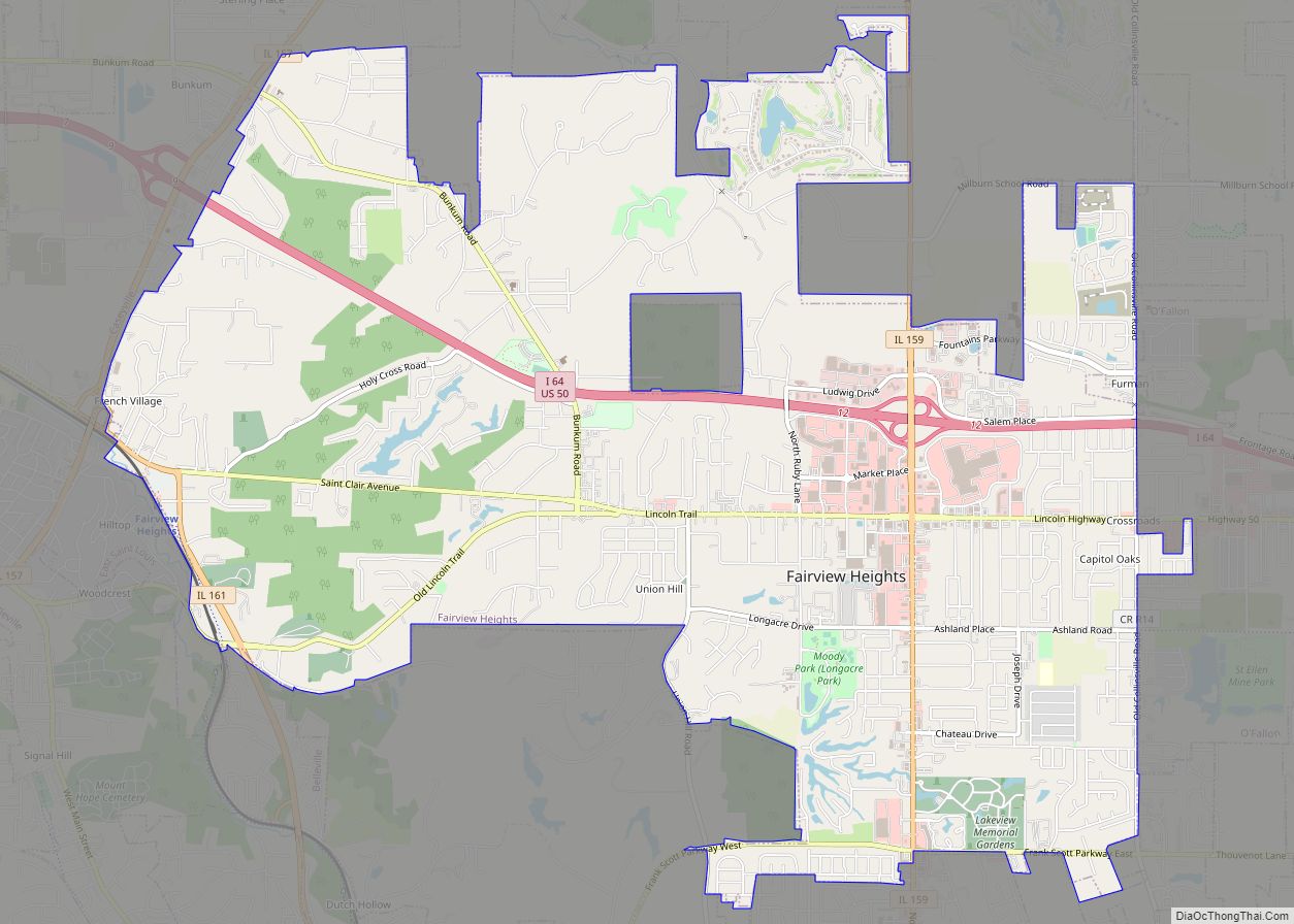
Fairview Heights is a city in St. Clair County, Illinois, United States within Greater St. Louis. It is an eastern suburb of St. Louis. The population was 17,078 at the 2010 census. Fairview Heights is a dominant shopping center for Greater St. Louis and Southern Illinois and includes numerous shopping plazas and St. Clair Square … Read more

Map of Farmer City city

Map of Farmer City

Farmer City is a city in DeWitt County, Illinois, United States. The population was 1,828 at the 2020 census. Farmer City is part of Blue Ridge Community Unit School District 18 sharing facilities with nearby Mansfield and Bellflower, Illinois. Farmer City facilities include the District Unit Office, the Ruth M. Schneider Elementary School (K-3) and … Read more

Map of Farina village

Map of Farina village

Farina is a village in Fayette and Marion counties, Illinois, United States. The population was 540 at the 2020 census. It is the only community with the name “Farina” in the United States. Farina village overview: Name: Farina village LSAD Code: 47 LSAD Description: village (suffix) State: Illinois County: Fayette County, Marion County Elevation: 574 ft … Read more

Map of Farmington city, Illinois

Map of Farmington city, Illinois

Farmington is a city in Fulton County & Peoria County, Illinois, United States. It is north of Canton, west of Peoria, southeast of Galesburg, and northeast of Macomb. The population was 2,448 at the 2010 census, down from 2,601 at the 2000 census. The public school system is Farmington Central Community Unit School District 265, … Read more

Map of Farmersville village, Illinois

Map of Farmersville village, Illinois

Farmersville is a village in Montgomery County, Illinois, United States. The population was 689 at the 2020 census. Farmersville village overview: Name: Farmersville village LSAD Code: 47 LSAD Description: village (suffix) State: Illinois County: Montgomery County Elevation: 640 ft (200 m) Total Area: 0.70 sq mi (1.82 km²) Land Area: 0.70 sq mi (1.82 km²) Water Area: 0.00 sq mi (0.00 km²) Total Population: 689 Population … Read more

Map of Ferris village

Map of Ferris village, Illinois

Ferris is a village in Hancock County, Illinois, United States. The population was 156 at the 2010 census. Ferris village overview: Name: Ferris village LSAD Code: 47 LSAD Description: village (suffix) State: Illinois County: Hancock County Elevation: 682 ft (208 m) Total Area: 1.97 sq mi (5.09 km²) Land Area: 1.97 sq mi (5.09 km²) Water Area: 0.00 sq mi (0.00 km²) Total Population: 127 Population … Read more

Map of Fayetteville village, Illinois

Map of Fayetteville village, Illinois

Fayetteville is a village on the Kaskaskia River in St. Clair County, Illinois, United States. The population was 384 at the 2000 census. Fayetteville village overview: Name: Fayetteville village LSAD Code: 47 LSAD Description: village (suffix) State: Illinois County: St. Clair County Elevation: 413 ft (126 m) Total Area: 0.30 sq mi (0.77 km²) Land Area: 0.30 sq mi (0.77 km²) Water Area: … Read more

Map of Fieldon village

Map of Fieldon village

Fieldon is a village in Jersey County, Illinois, United States. As of the 2020 census, the village had a total population of 176. The village’s current mayor is Julia Dixon. Fieldon village overview: Name: Fieldon village LSAD Code: 47 LSAD Description: village (suffix) State: Illinois County: Jersey County Elevation: 692 ft (211 m) Total Area: 0.20 sq mi (0.52 km²) … Read more

Map of Fidelity village

Map of Fidelity village, Illinois

Fidelity is a village in Jersey County, Illinois, United States, located about thirty-five miles north of Saint Louis, Missouri. As of the 2020 census, the village had a total population of 96. The village is usually noted for its postmark. Fidelity village overview: Name: Fidelity village LSAD Code: 47 LSAD Description: village (suffix) State: Illinois … Read more

Map of Findlay village

Map of Findlay village, Illinois

Findlay is a village in Shelby County, Illinois, United States. The population was 664 at the 2020 census. Findlay village overview: Name: Findlay village LSAD Code: 47 LSAD Description: village (suffix) State: Illinois County: Shelby County Elevation: 682 ft (208 m) Total Area: 0.92 sq mi (2.39 km²) Land Area: 0.92 sq mi (2.39 km²) Water Area: 0.00 sq mi (0.00 km²) Total Population: 664 Population … Read more

Map of Fillmore village, Illinois

Map of Fillmore village, Illinois

Fillmore is a village in Montgomery County, Illinois, United States. The population was 305 at the 2020 census. Fillmore village overview: Name: Fillmore village LSAD Code: 47 LSAD Description: village (suffix) State: Illinois County: Montgomery County Elevation: 633 ft (193 m) Total Area: 0.96 sq mi (2.48 km²) Land Area: 0.96 sq mi (2.48 km²) Water Area: 0.00 sq mi (0.00 km²) Total Population: 305 Population … Read more

Map of Fithian village

Map of Fithian village

Fithian is a village in Oakwood Township, Vermilion County, Illinois, United States. It is part of the Danville, Illinois Metropolitan Statistical Area. The population was 485 at the 2010 census. Fithian village overview: Name: Fithian village LSAD Code: 47 LSAD Description: village (suffix) State: Illinois County: Vermilion County Elevation: 663 ft (202 m) Total Area: 0.38 sq mi (0.99 km²) … Read more