Map of Gilberts village

Map of Gilberts village

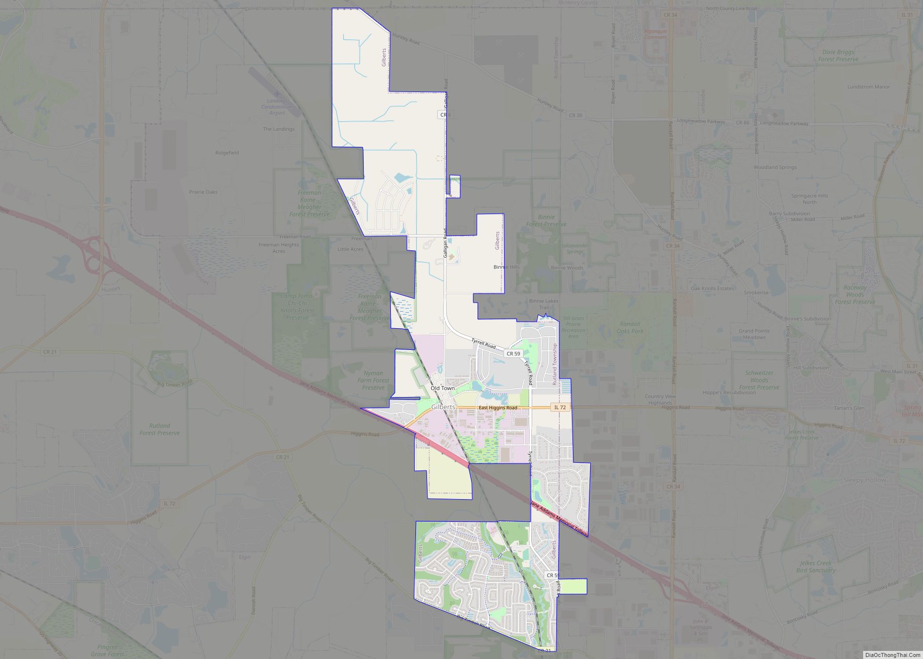
Gilberts is a village in Kane County, Illinois, United States. The population was 8,366 at the 2020 census. Gilberts village overview: Name: Gilberts village LSAD Code: 47 LSAD Description: village (suffix) State: Illinois County: Kane County Total Area: 5.49 sq mi (14.22 km²) Land Area: 5.49 sq mi (14.22 km²) Water Area: 0.00 sq mi (0.00 km²) Total Population: 8,366 Population Density: 1,524.14/sq mi (588.44/km²) … Read more

Map of Gilson CDP

Map of Gilson CDP

Gilson is an unincorporated census-designated place in Knox County, Illinois, and is located southeast of Galesburg. As of the 2010 Census, its population was 190. It is part of the Galesburg Micropolitan Statistical Area. Gilson is located just east of Illinois Route 97 along Knox County Highway 12. The BNSF Railway runs through the town. … Read more

Map of Gilman city, Illinois

Map of Gilman city, Illinois

Gilman is a city in Douglas Township, Iroquois County, Illinois, United States. The population was 1,738 at the 2020 census. Gilman city overview: Name: Gilman city LSAD Code: 25 LSAD Description: city (suffix) State: Illinois County: Iroquois County Elevation: 650 ft (198 m) Total Area: 2.45 sq mi (6.35 km²) Land Area: 2.43 sq mi (6.30 km²) Water Area: 0.02 sq mi (0.05 km²) Total Population: … Read more

Map of Gladstone village

Map of Gladstone village, Illinois

Gladstone is a village in Henderson County, Illinois, United States. The population was 281 at the 2010 census, down from 284 in 2000. It is part of the Burlington, IA–IL Micropolitan Statistical Area. Gladstone village overview: Name: Gladstone village LSAD Code: 47 LSAD Description: village (suffix) State: Illinois County: Henderson County Elevation: 558 ft (170 m) Total … Read more

Map of Girard city, Illinois

Map of Girard city, Illinois

Girard is a city in Macoupin County, Illinois, United States. The population was 1,785 at the 2020 census, down from 2,103 in 2010. Girard city overview: Name: Girard city LSAD Code: 25 LSAD Description: city (suffix) State: Illinois County: Macoupin County Elevation: 669 ft (204 m) Total Area: 0.93 sq mi (2.42 km²) Land Area: 0.93 sq mi (2.42 km²) Water Area: 0.00 sq mi … Read more

Map of Glasgow village, Illinois

Map of Glasgow village, Illinois

Glasgow is a village in Scott County, Illinois, United States. The population was 170 at the 2000 census. It is part of the Jacksonville Micropolitan Statistical Area. Glasgow village overview: Name: Glasgow village LSAD Code: 47 LSAD Description: village (suffix) State: Illinois County: Scott County Elevation: 584 ft (178 m) Total Area: 1.01 sq mi (2.62 km²) Land Area: 1.01 sq mi … Read more

Map of Glasford village

Map of Glasford village

Glasford is a village in Peoria County, Illinois, United States. The population was 1,022 at the 2010 census. Glasford is part of the Peoria, Illinois Metropolitan Statistical Area. Glasford village overview: Name: Glasford village LSAD Code: 47 LSAD Description: village (suffix) State: Illinois County: Peoria County Total Area: 0.91 sq mi (2.35 km²) Land Area: 0.91 sq mi (2.35 km²) Water … Read more

Map of Glen Ellyn village

Map of Glen Ellyn village

Glen Ellyn is a village in DuPage County, Illinois, United States. A suburb located 24 miles (39 km) due west of downtown Chicago, the village has a population of 28,846 as of the 2020 Census. Glen Ellyn village overview: Name: Glen Ellyn village LSAD Code: 47 LSAD Description: village (suffix) State: Illinois County: DuPage County Incorporated: … Read more

Map of Glen Carbon village

Map of Glen Carbon village

Glen Carbon is a village in Madison County, Illinois, United States, 14 miles (23 km) northeast of St. Louis. The population was 13,842 at the 2020 census. Glen Carbon village overview: Name: Glen Carbon village LSAD Code: 47 LSAD Description: village (suffix) State: Illinois County: Madison County Founded: 1892 Elevation: 505 ft (154 m) Total Area: 10.37 sq mi (26.86 km²) … Read more

Map of Glendale Heights village

Map of Glendale Heights village

Glendale Heights is a village in DuPage County, Illinois, United States. Per the 2020 census, the population was 33,176. The village is almost entirely residential, and is a far west suburb of Chicago. Glendale Heights village overview: Name: Glendale Heights village LSAD Code: 47 LSAD Description: village (suffix) State: Illinois County: DuPage County Incorporated: 1959 … Read more

Map of Glencoe village, Illinois

Map of Glencoe village, Illinois

Glencoe (/ˈɡlɛnˌkoʊ/) is a lakefront village in northeastern Cook County, Illinois, United States. As of the 2020 census, the population was 8,849. Glencoe is part of Chicago’s North Shore and is located within the New Trier High School District. Glencoe has the eighth highest income per household among municipalities in the U.S. with greater than … Read more

Map of Glenwood village, Illinois

Map of Glenwood village, Illinois

Glenwood is a village in Cook County, Illinois, United States. The population was 8,662 at the 2020 census. Glenwood village overview: Name: Glenwood village LSAD Code: 47 LSAD Description: village (suffix) State: Illinois County: Cook County Incorporated: 1903 Total Area: 3.26 sq mi (8.45 km²) Land Area: 3.26 sq mi (8.45 km²) Water Area: 0.00 sq mi (0.00 km²)  0% Total Population: 8,662 Population … Read more