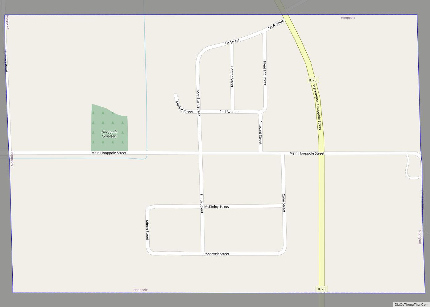
Map of Hoopeston city

Map of Hoopeston city

Hoopeston (/ˈhʊpstən/) is a city in Grant Township, Vermilion County, Illinois, United States. As of the 2020 census, the city population was 4,915. Hoopeston city overview: Name: Hoopeston city LSAD Code: 25 LSAD Description: city (suffix) State: Illinois County: Vermilion County Founded: 1871 Incorporated: 1877 Elevation: 719 ft (219 m) Total Area: 3.69 sq mi (9.55 km²) Land Area: 3.69 sq mi … Read more

Map of Hopewell village

Map of Hopewell village, Illinois

Hopewell is a village in Marshall County, Illinois, United States. The population was 421 at the 2020 census. It is part of the Peoria Metropolitan Statistical Area. The village was incorporated in 1983. Hopewell village overview: Name: Hopewell village LSAD Code: 47 LSAD Description: village (suffix) State: Illinois County: Marshall County Elevation: 486 ft (148 m) Total … Read more

Map of Hopedale village

Map of Hopedale village, Illinois

Hopedale is a village in Tazewell County, Illinois, United States. The population was 865 at the 2010 census. It is part of the Peoria, Illinois Metropolitan Statistical Area. The town is also home to a small number of restaurants, general stores, parks, and the Hopedale Medical Complex. Hopedale village overview: Name: Hopedale village LSAD Code: … Read more

Map of Hoyleton village

Map of Hoyleton village

Hoyleton is a village in Washington County, Illinois, United States. The population was 531 at the 2010 census. It is the hometown of former Montréal Expos and San Francisco Giants left-handed pitcher Kirk Rueter. Hoyleton village overview: Name: Hoyleton village LSAD Code: 47 LSAD Description: village (suffix) State: Illinois County: Washington County Elevation: 528 ft (161 m) … Read more

Map of Hopkins Park village

Map of Hopkins Park village

Hopkins Park is a village in Kankakee County, Illinois, United States. The population was 603 at the 2010 census, down from 711 at the 2000 census. It is part of the Kankakee–Bradley Metropolitan Statistical Area. Hopkins Park village overview: Name: Hopkins Park village LSAD Code: 47 LSAD Description: village (suffix) State: Illinois County: Kankakee County … Read more

Map of Huey village

Map of Huey village

Huey is a village in Clinton County, Illinois, in the United States. As of the 2020 census, the village population was 160. Huey village overview: Name: Huey village LSAD Code: 47 LSAD Description: village (suffix) State: Illinois County: Clinton County Elevation: 449 ft (137 m) Total Area: 0.22 sq mi (0.56 km²) Land Area: 0.22 sq mi (0.56 km²) Water Area: 0.00 sq mi (0.00 km²) … Read more

Map of Hudson village, Illinois

Map of Hudson village, Illinois

Hudson is a village in McLean County, Illinois, United States. The population was 1,753 at the 2020 census. It is part of the Bloomington–Normal Metropolitan Statistical Area. Hudson village overview: Name: Hudson village LSAD Code: 47 LSAD Description: village (suffix) State: Illinois County: McLean County Elevation: 764 ft (233 m) Total Area: 0.82 sq mi (2.12 km²) Land Area: 0.82 sq mi … Read more

Map of Humboldt village, Illinois

Map of Humboldt village, Illinois

Humboldt is a village in Coles County, Illinois, United States. At the 2020 census, its population was 361. It is part of the Charleston-Mattoon Micropolitan Statistical Area. Humboldt village overview: Name: Humboldt village LSAD Code: 47 LSAD Description: village (suffix) State: Illinois County: Coles County Incorporated: April 16, 1878 (1878-04-16) Elevation: 659 ft (201 m) Total Area: 0.34 sq mi (0.89 km²) Land … Read more

Map of Hull village, Illinois

Map of Hull village, Illinois

Hull is a village in Pike County, Illinois, United States. The population was 461 at the 2010 census, a decline from 474 in 2000. Hull village overview: Name: Hull village LSAD Code: 47 LSAD Description: village (suffix) State: Illinois County: Pike County Elevation: 469 ft (143 m) Total Area: 1.84 sq mi (4.76 km²) Land Area: 1.82 sq mi (4.73 km²) Water Area: … Read more

Map of Huntley village

Map of Huntley village, Illinois

Huntley is a village in McHenry and Kane counties, Illinois, United States. As of the 2020 census it had a population of 27,740. It is a part of the Chicago metropolitan area. Huntley village overview: Name: Huntley village LSAD Code: 47 LSAD Description: village (suffix) State: Illinois County: Kane County, McHenry County Founded: 1851 (1851) Incorporated: … Read more

Map of Hume village

Map of Hume village, Illinois

Hume is a village in Shiloh and Young America townships, Edgar County, Illinois, United States. As of the 2020 census, the village population was 325. Hume village overview: Name: Hume village LSAD Code: 47 LSAD Description: village (suffix) State: Illinois County: Edgar County Incorporated: 1873 Elevation: 653 ft (199 m) Total Area: 0.57 sq mi (1.47 km²) Land Area: 0.57 sq mi … Read more

Map of Hutsonville village

Map of Hutsonville village

Hutsonville is a village in Crawford County, Illinois, United States. The population was 478 at the 2020 census. Hutsonville village overview: Name: Hutsonville village LSAD Code: 47 LSAD Description: village (suffix) State: Illinois County: Crawford County Elevation: 449 ft (137 m) Total Area: 0.62 sq mi (1.61 km²) Land Area: 0.62 sq mi (1.61 km²) Water Area: 0.00 sq mi (0.00 km²) Total Population: 478 Population … Read more