Map of St. David village, Illinois

Map of St. David village, Illinois

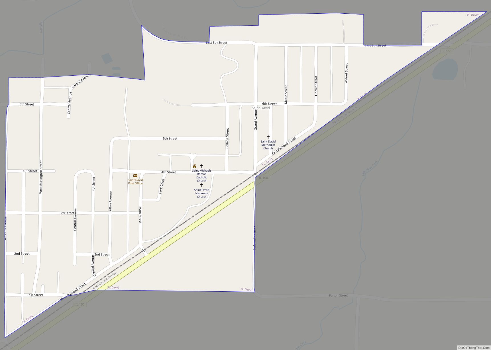
St. David is a village in Fulton County, Illinois, United States. The population was 589 at the 2010 census. St. David village overview: Name: St. David village LSAD Code: 47 LSAD Description: village (suffix) State: Illinois County: Fulton County Founded: July 25, 1885 Elevation: 630 ft (190 m) Total Area: 0.30 sq mi (0.77 km²) Land Area: 0.30 sq mi (0.77 km²) Water … Read more

Map of St. Jacob village

Map of St. Jacob village

St. Jacob or Saint Jacob is a village in Madison County, Illinois, United States. The population was 1,358 at the 2020 census, up from 1,098 in 2010. St. Jacob village overview: Name: St. Jacob village LSAD Code: 47 LSAD Description: village (suffix) State: Illinois County: Madison County Elevation: 512 ft (156 m) Total Area: 0.85 sq mi (2.21 km²) Land … Read more

Map of St. Francisville city

Map of St. Francisville city, Illinois

St. Francisville or Saint Francisville is a city in Lawrence County, Illinois, United States. The population was 697 at the 2010 census. St. Francisville city overview: Name: St. Francisville city LSAD Code: 25 LSAD Description: city (suffix) State: Illinois County: Lawrence County Elevation: 459 ft (140 m) Total Area: 0.78 sq mi (2.02 km²) Land Area: 0.74 sq mi (1.93 km²) Water Area: … Read more

Map of St. Joseph village, Illinois

Map of St. Joseph village, Illinois

The Village of St. Joseph was founded on 28 April 1881 and is located in St. Joseph Township, Champaign County, Illinois, United States. The population was 3,810 at the 2020 census, down from 3,967 at the 2010 census. St. Joseph village overview: Name: St. Joseph village LSAD Code: 47 LSAD Description: village (suffix) State: Illinois … Read more

Map of St. Johns village, Illinois

Map of St. Johns village, Illinois

St. Johns (Saint Johns) is a village in Perry County, Illinois, United States. The population was 218 at the 2000 census. The village was named in 1856 after St. John’s Day. St. Johns village overview: Name: St. Johns village LSAD Code: 47 LSAD Description: village (suffix) State: Illinois County: Perry County Elevation: 463 ft (141 m) Total … Read more

Map of St. Peter village

Map of St. Peter village, Illinois

St. Peter or Saint Peter is a village in Fayette County, Illinois, United States. The population was 359 at the 2010 census. St. Peter village overview: Name: St. Peter village LSAD Code: 47 LSAD Description: village (suffix) State: Illinois County: Fayette County Elevation: 591 ft (180 m) Total Area: 0.52 sq mi (1.35 km²) Land Area: 0.52 sq mi (1.35 km²) Water Area: … Read more

Map of St. Libory village

Map of St. Libory village, Illinois

St. Libory or Saint Libory is a village in St. Clair County, Illinois, United States. The population was 615 at the 2010 census. St. Libory village overview: Name: St. Libory village LSAD Code: 47 LSAD Description: village (suffix) State: Illinois County: St. Clair County Elevation: 417 ft (127 m) Total Area: 0.97 sq mi (2.52 km²) Land Area: 0.97 sq mi (2.52 km²) … Read more

Map of Standard City village

Map of Standard City village

Standard City is a village in Macoupin County, Illinois, United States. The population was 135 at the 2020 census. Standard City village overview: Name: Standard City village LSAD Code: 47 LSAD Description: village (suffix) State: Illinois County: Macoupin County Elevation: 636 ft (194 m) Total Area: 0.64 sq mi (1.66 km²) Land Area: 0.64 sq mi (1.65 km²) Water Area: 0.00 sq mi (0.01 km²) Total … Read more

Map of St. Rose village

Map of St. Rose village, Illinois

Saint Rose is a village in Clinton County, Illinois, United States. Saint Rose is 5 miles (8.0 km) north-northwest of Breese. The population was 459 as of the 2020 census. St. Rose village overview: Name: St. Rose village LSAD Code: 47 LSAD Description: village (suffix) State: Illinois County: Clinton County Elevation: 499 ft (152 m) Total Area: 0.59 sq mi … Read more

Map of Standard village

Map of Standard village

Standard is a village in Putnam County, Illinois, United States. The population was 220 at the 2010 census, down from 256 in 2000. It is part of the Ottawa Micropolitan Statistical Area. Standard village overview: Name: Standard village LSAD Code: 47 LSAD Description: village (suffix) State: Illinois County: Putnam County Total Area: 0.71 sq mi (1.84 km²) Land … Read more

Map of Stanford village, Illinois

Map of Stanford village, Illinois

Stanford is a village in McLean County, Illinois, United States. The population was 600 at the 2020 census. It is part of the Bloomington–Normal Metropolitan Statistical Area. Stanford village overview: Name: Stanford village LSAD Code: 47 LSAD Description: village (suffix) State: Illinois County: McLean County Elevation: 673 ft (205 m) Total Area: 0.66 sq mi (1.71 km²) Land Area: 0.66 sq mi … Read more

Map of Ste. Marie village

Map of Ste. Marie village

Ste. Marie is a village in Jasper County, Illinois, United States, along the Embarras River. The population was 244 at the 2010 census. Ste. Marie village overview: Name: Ste. Marie village LSAD Code: 47 LSAD Description: village (suffix) State: Illinois County: Jasper County Elevation: 486 ft (148 m) Total Area: 1.11 sq mi (2.87 km²) Land Area: 1.11 sq mi (2.87 km²) Water … Read more