Map of Gillett Grove city
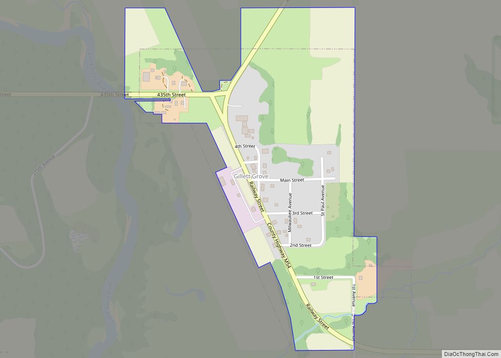
Gillett Grove is a city in Clay County, Iowa, United States. The population was 30 in the 2020 census, a decline from 55 in 2000. Gillett Grove city overview: Name: Gillett Grove city LSAD Code: 25 LSAD Description: city (suffix) State: Iowa County: Clay County Elevation: 1,306 ft (398 m) Total Area: 0.22 sq mi (0.57 km²) Land Area: 0.22 sq mi ... Read more
Map of Gillett Grove city
Map of Gilbertville city
Gilbertville is a city in Black Hawk County, Iowa, United States. The population was 794 at the time of the 2020 census. It is part of the Waterloo–Cedar Falls Metropolitan Statistical Area. Gilbertville city overview: Name: Gilbertville city LSAD Code: 25 LSAD Description: city (suffix) State: Iowa County: Black Hawk County Elevation: 846 ft (258 m) Total ... Read more
Map of Gilbertville city
Map of Glenwood city, Iowa
Glenwood is a city in, and the county seat of, Mills County, Iowa, United States. The population was 5,073 in the 2020 census, a decline from 5,358 in 2000. Glenwood city overview: Name: Glenwood city LSAD Code: 25 LSAD Description: city (suffix) State: Iowa County: Mills County Elevation: 1,017 ft (310 m) Total Area: 2.94 sq mi (7.60 km²) Land ... Read more
Map of Glenwood city, Iowa
Map of Gladbrook city
Gladbrook is a city in Tama County, Iowa, United States. The population was 799 at the time of the 2020 census. Gladbrook city overview: Name: Gladbrook city LSAD Code: 25 LSAD Description: city (suffix) State: Iowa County: Tama County Elevation: 974 ft (297 m) Total Area: 0.70 sq mi (1.81 km²) Land Area: 0.70 sq mi (1.81 km²) Water Area: 0.00 sq mi (0.00 km²) Total ... Read more
Map of Gladbrook city
Map of Gilmore City
Gilmore City is a city in Humboldt and Pocahontas counties in the U.S. state of Iowa. The population was 487 at the time of the 2020 census. Gilmore City city overview: Name: Gilmore City city LSAD Code: 25 LSAD Description: city (suffix) State: Iowa County: Humboldt County, Pocahontas County Elevation: 1,224 ft (373 m) Total Area: 1.24 sq mi ... Read more
Map of Gilmore City
Map of Goodell city
Goodell is a city in Hancock County, Iowa, United States. The population was 140 at the time of the 2020 census. Goodell city overview: Name: Goodell city LSAD Code: 25 LSAD Description: city (suffix) State: Iowa County: Hancock County Elevation: 1,243 ft (379 m) Total Area: 0.43 sq mi (1.12 km²) Land Area: 0.43 sq mi (1.12 km²) Water Area: 0.00 sq mi (0.00 km²) Total ... Read more
Map of Goodell city
Map of Goldfield city, Iowa
Goldfield is a city in Wright County, Iowa, United States. The population was 634 at the time of the 2020 census. Goldfield city overview: Name: Goldfield city LSAD Code: 25 LSAD Description: city (suffix) State: Iowa County: Wright County Elevation: 1,129 ft (344 m) Total Area: 1.18 sq mi (3.04 km²) Land Area: 1.18 sq mi (3.04 km²) Water Area: 0.00 sq mi (0.00 km²) Total ... Read more
Map of Goldfield city, Iowa
Map of Glidden city, Iowa
Glidden is a town in Carroll County, Iowa, United States. The population was 1,151 at the time of the 2020 census. Glidden city overview: Name: Glidden city LSAD Code: 25 LSAD Description: city (suffix) State: Iowa County: Carroll County Elevation: 1,237 ft (377 m) Total Area: 1.10 sq mi (2.84 km²) Land Area: 1.10 sq mi (2.84 km²) Water Area: 0.00 sq mi (0.00 km²) Total ... Read more
Map of Glidden city, Iowa
Map of Goose Lake city
Goose Lake is a city in Clinton County, Iowa, United States. The population was 239 at the time of the 2020 census. Goose Lake city overview: Name: Goose Lake city LSAD Code: 25 LSAD Description: city (suffix) State: Iowa County: Clinton County Elevation: 689 ft (210 m) Total Area: 0.33 sq mi (0.86 km²) Land Area: 0.33 sq mi (0.86 km²) Water Area: ... Read more
Map of Goose Lake city
Map of Graettinger city
Graettinger is a city in Palo Alto County, Iowa, United States. The population was 832 at the time of the 2020 census. Graettinger city overview: Name: Graettinger city LSAD Code: 25 LSAD Description: city (suffix) State: Iowa County: Palo Alto County Elevation: 1,253 ft (382 m) Total Area: 0.75 sq mi (1.95 km²) Land Area: 0.75 sq mi (1.95 km²) Water Area: 0.00 sq mi ... Read more
Map of Graettinger city
Map of Gowrie city
Gowrie is a city in Webster County, Iowa. The population was 952 at the time of the 2020 census. The town has a swimming pool, golf course, athletic stadium, and curb-and-gutter throughout the community. Gowrie city overview: Name: Gowrie city LSAD Code: 25 LSAD Description: city (suffix) State: Iowa County: Webster County Elevation: 1,142 ft (348 m) ... Read more
Map of Gowrie city
Map of Grand Junction city, Iowa
Grand Junction is a city in Greene County, Iowa, United States. The population was 725 at the time of the 2020 census. Grand Junction city overview: Name: Grand Junction city LSAD Code: 25 LSAD Description: city (suffix) State: Iowa County: Greene County Elevation: 1,037 ft (316 m) Total Area: 0.97 sq mi (2.51 km²) Land Area: 0.97 sq mi (2.51 km²) Water Area: ... Read more
Map of Grand Junction city, Iowa