Map of Springbrook city

Map of Springbrook city, Iowa

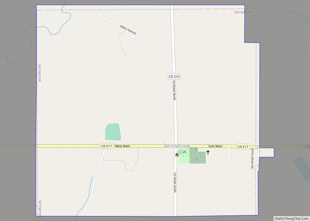
Springbrook is a small city in central Jackson County, Iowa, United States. The population was 143 at the time of the 2020 census. Springbrook city overview: Name: Springbrook city LSAD Code: 25 LSAD Description: city (suffix) State: Iowa County: Jackson County Incorporated: March 2, 1897 Elevation: 860 ft (262 m) Total Area: 0.60 sq mi (1.57 km²) Land Area: 0.60 sq mi … Read more

Map of Spring Hill city, Iowa

Map of Spring Hill city, Iowa

Spring Hill is a city in Warren County, Iowa, United States. The population was 68 at the time of the 2020 census. It is part of the Des Moines–West Des Moines Metropolitan Statistical Area. Spring Hill city overview: Name: Spring Hill city LSAD Code: 25 LSAD Description: city (suffix) State: Iowa County: Warren County Elevation: … Read more

Map of St. Benedict CDP

Map of St. Benedict CDP

St. Benedict is an unincorporated community and census-designated place (CDP) in Prairie Township, Kossuth County, Iowa, United States. As of the 2010 census it had a population of 39. St. Benedict was platted in 1899. St. Benedict CDP overview: Name: St. Benedict CDP LSAD Code: 57 LSAD Description: CDP (suffix) State: Iowa County: Kossuth County … Read more

Map of St. Anthony city

Map of St. Anthony city, Iowa

St. Anthony is a city in Marshall County, Iowa, United States. The population was 76 at the time of the 2020 census. St. Anthony city overview: Name: St. Anthony city LSAD Code: 25 LSAD Description: city (suffix) State: Iowa County: Marshall County Elevation: 1,010 ft (308 m) Total Area: 0.61 sq mi (1.59 km²) Land Area: 0.61 sq mi (1.59 km²) Water Area: … Read more

Map of St. Ansgar city

Map of St. Ansgar city

St. Ansgar is a city in Mitchell County, Iowa, United States. The population was 1,160 at the 2020 census. St. Ansgar city overview: Name: St. Ansgar city LSAD Code: 25 LSAD Description: city (suffix) State: Iowa County: Mitchell County Elevation: 1,171 ft (357 m) Total Area: 1.09 sq mi (2.82 km²) Land Area: 1.09 sq mi (2.82 km²) Water Area: 0.00 sq mi (0.00 km²) Total … Read more

Map of St. Joseph CDP

Map of St. Joseph CDP, Iowa

St. Joseph is an unincorporated community and census-designated place (CDP) in Riverdale Township, Kossuth County, Iowa, United States. As of the 2010 census the population was 61. St. Joseph CDP overview: Name: St. Joseph CDP LSAD Code: 57 LSAD Description: CDP (suffix) State: Iowa County: Kossuth County Elevation: 1,110 ft (340 m) Total Area: 0.86 sq mi (2.23 km²) Land … Read more

Map of St. Donatus city

Map of St. Donatus city

St. Donatus is a city in Jackson County, Iowa, United States. The population was 120 at the time of the 2020 census. St. Donatus (AKA “Ocho Casera”) is known for its status as a Luxembourger village, with historic architecture and views along U.S. Route 52. It is the home of a historic Catholic church, which … Read more

Map of St. Charles city, Iowa

Map of St. Charles city, Iowa

St. Charles is a city in Madison County, Iowa, United States. The population was 640 at the time of the 2020 census. It is part of the Des Moines–West Des Moines Metropolitan Statistical Area. St. Charles city overview: Name: St. Charles city LSAD Code: 25 LSAD Description: city (suffix) State: Iowa County: Madison County Elevation: … Read more

Map of St. Olaf city

Map of St. Olaf city

St. Olaf is a city in Clayton County, Iowa, United States. The population was 106 at the time of the 2020 census, down from 136 in 2000. Swiss Valley has a large cheese packaging plant in St. Olaf. St. Olaf city overview: Name: St. Olaf city LSAD Code: 25 LSAD Description: city (suffix) State: Iowa … Read more

Map of St. Marys city, Iowa

Map of St. Marys city, Iowa

St. Marys is a city in Warren County, Iowa, United States. The population was 108 at the time of the 2020 census. St. Marys is part of the Des Moines–West Des Moines Metropolitan Statistical Area. St. Marys city overview: Name: St. Marys city LSAD Code: 25 LSAD Description: city (suffix) State: Iowa County: Warren County … Read more

Map of St. Lucas city

Map of St. Lucas city

St. Lucas is a city in Fayette County, Iowa, United States. The population was 167 at the time of the 2020 census. St. Lucas city overview: Name: St. Lucas city LSAD Code: 25 LSAD Description: city (suffix) State: Iowa County: Fayette County Incorporated: March 6, 1900 Elevation: 1,056 ft (322 m) Total Area: 0.25 sq mi (0.66 km²) Land Area: … Read more

Map of Stanhope city

Map of Stanhope city, Iowa

Stanhope is a city in Hamilton County, Iowa, United States. The population was 364 at the time of the 2020 census. Stanhope city overview: Name: Stanhope city LSAD Code: 25 LSAD Description: city (suffix) State: Iowa County: Hamilton County Elevation: 1,115 ft (340 m) Total Area: 0.98 sq mi (2.54 km²) Land Area: 0.98 sq mi (2.54 km²) Water Area: 0.00 sq mi (0.00 km²) Total … Read more