Map of Stout city

Map of Stout city

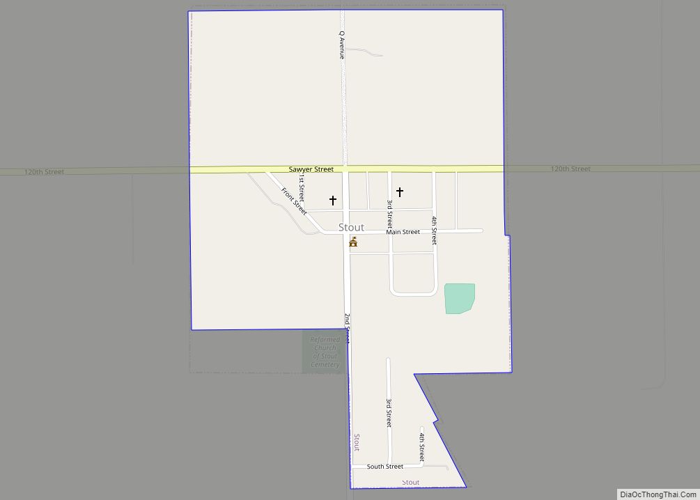
Stout is a city in Grundy County, Iowa, United States. The population was 191 in the 2020 census, a decrease from the population of 217 in 2000. It is part of the Waterloo–Cedar Falls Metropolitan Statistical Area. Stout city overview: Name: Stout city LSAD Code: 25 LSAD Description: city (suffix) State: Iowa County: Grundy County … Read more

Map of Story City city

Map of Story City

Story City is a city in Story County, Iowa. It is located within the Ames, Iowa Metropolitan Statistical Area which envelops the entirety of Story County and combined with the Boone, Iowa Micropolitan Statistical Area makes up the larger Ames-Boone, Iowa Combined Statistical Area. The population was 3,352 in the 2020 census, a slight increase … Read more

Map of Stuart city, Iowa

Map of Stuart city, Iowa

Stuart is a city in Lincoln Township, Adair County, and in Stuart Township, Guthrie County, in the U.S. state of Iowa. That part of the city within Guthrie County is part of the Des Moines–West Des Moines Metropolitan Statistical Area. The population was 1,782 at the 2020 census. Stuart city overview: Name: Stuart city LSAD … Read more

Map of Struble city

Map of Struble city

Struble is a city in Plymouth County, Iowa, United States, along the West Branch of the Floyd River. The population was 67 at the time of the 2020 census. Struble city overview: Name: Struble city LSAD Code: 25 LSAD Description: city (suffix) State: Iowa County: Plymouth County Elevation: 1,266 ft (386 m) Total Area: 0.16 sq mi (0.40 km²) Land … Read more

Map of Strawberry Point city

Map of Strawberry Point city

Strawberry Point is a city in Clayton County, Iowa, United States. The population was 1,155 at the time of the 2020 United States Census, down from 1,386 in 2000 census. Strawberry Point is home to the world’s largest strawberry (a 15-foot fiberglass statue), and the Franklin Hotel, which was listed on the National Register of … Read more

Map of Sun Valley Lake CDP

Map of Sun Valley Lake CDP

Sun Valley Lake is an unincorporated community and census-designated place in Ringgold County, Iowa, United States. Its population was 161 as of the 2010 census. The community is located in northeastern Ringgold County on the shores of its namesake lake. Sun Valley Lake CDP overview: Name: Sun Valley Lake CDP LSAD Code: 57 LSAD Description: … Read more

Map of Sumner city, Iowa

Map of Sumner city, Iowa

Sumner is a city in Bremer County, Iowa, United States. The city is located along the county’s eastern border, between Bremer and Fayette counties. The population was 2,021 at the time of the 2020 census. The Bremer County portion of Sumner is part of the Waterloo–Cedar Falls Metropolitan Statistical Area. The town was established in … Read more

Map of Sully city

Map of Sully city

Sully is a city located in Jasper County, Iowa, United States, named after railroad man Alfred Sully. The population was 881 at the time of the 2020 census. Sully city overview: Name: Sully city LSAD Code: 25 LSAD Description: city (suffix) State: Iowa County: Jasper County Elevation: 919 ft (280 m) Total Area: 0.58 sq mi (1.51 km²) Land Area: … Read more

Map of Sutherland city

Map of Sutherland city, Iowa

Sutherland is a city in O’Brien County, Iowa, United States. The population was 629 at the time of the 2020 census. Sutherland city overview: Name: Sutherland city LSAD Code: 25 LSAD Description: city (suffix) State: Iowa County: O’Brien County Elevation: 1,427 ft (435 m) Total Area: 0.85 sq mi (2.20 km²) Land Area: 0.85 sq mi (2.20 km²) Water Area: 0.00 sq mi (0.00 km²) Total … Read more

Map of Superior city, Iowa

Map of Superior city, Iowa

Superior is a city in Dickinson County, Iowa, United States. The population was 132 at the time of the 2020 census. Superior city overview: Name: Superior city LSAD Code: 25 LSAD Description: city (suffix) State: Iowa County: Dickinson County Elevation: 1,499 ft (457 m) Total Area: 0.43 sq mi (1.11 km²) Land Area: 0.43 sq mi (1.11 km²) Water Area: 0.00 sq mi (0.00 km²) Total … Read more

Map of Swaledale city

Map of Swaledale city

Swaledale is a city in Cerro Gordo County, Iowa, United States. The population was 144 at the time of the 2020 census. It is part of the Mason City Micropolitan Statistical Area. Swaledale city overview: Name: Swaledale city LSAD Code: 25 LSAD Description: city (suffix) State: Iowa County: Cerro Gordo County Elevation: 1,152 ft (351 m) Total … Read more

Map of Swisher city

Map of Swisher city

Swisher is a city in Johnson County, Iowa, United States. It is part of the Iowa City, Iowa Metropolitan Statistical Area. The population was 914 at the time of the 2020 census. Swisher city overview: Name: Swisher city LSAD Code: 25 LSAD Description: city (suffix) State: Iowa County: Johnson County Elevation: 791 ft (241 m) Total Area: … Read more