Map of Thurman city

Map of Thurman city

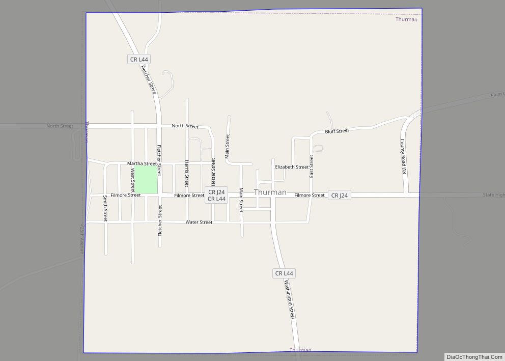
Thurman is a city in Fremont County, Iowa. As of the 2020 census, the city population was 167. Thurman city overview: Name: Thurman city LSAD Code: 25 LSAD Description: city (suffix) State: Iowa County: Fremont County Elevation: 978 ft (298 m) Total Area: 0.56 sq mi (1.46 km²) Land Area: 0.56 sq mi (1.46 km²) Water Area: 0.00 sq mi (0.00 km²) Total Population: 167 Population … Read more

Map of Thornton city, Iowa

Map of Thornton city, Iowa

Thornton is a city in Cerro Gordo County, Iowa, United States. The population was 400 at the time of the 2020 census. It is part of the Mason City Micropolitan Statistical Area. Thornton city overview: Name: Thornton city LSAD Code: 25 LSAD Description: city (suffix) State: Iowa County: Cerro Gordo County Elevation: 1,188 ft (362 m) Total … Read more

Map of Titonka city

Map of Titonka city

Titonka is a city in Kossuth County, Iowa, United States. The population was 511 at the time of the 2020 census. Titonka city overview: Name: Titonka city LSAD Code: 25 LSAD Description: city (suffix) State: Iowa County: Kossuth County Elevation: 1,161 ft (354 m) Total Area: 0.28 sq mi (0.73 km²) Land Area: 0.28 sq mi (0.73 km²) Water Area: 0.00 sq mi (0.00 km²) Total … Read more

Map of Tipton city, Iowa

Map of Tipton city, Iowa

Tipton (/ˈtɪptən/) is a city in Cedar County, Iowa, United States. The population was 3,149 at the time of the 2020 census. It is the county seat of Cedar County. Tipton city overview: Name: Tipton city LSAD Code: 25 LSAD Description: city (suffix) State: Iowa County: Cedar County Elevation: 823 ft (251 m) Total Area: 2.02 sq mi (5.24 km²) … Read more

Map of Tingley city

Map of Tingley city

Tingley is a city in northern Ringgold County, Iowa, United States. The population was 136 at the time of the 2020 census. Tingley city overview: Name: Tingley city LSAD Code: 25 LSAD Description: city (suffix) State: Iowa County: Ringgold County Elevation: 1,257 ft (383 m) Total Area: 0.69 sq mi (1.78 km²) Land Area: 0.69 sq mi (1.77 km²) Water Area: 0.00 sq mi (0.01 km²) … Read more

Map of Toronto city

Map of Toronto city, Iowa

Toronto is a town in Clinton County, Iowa, United States. The population was 102 at the time of the 2020 census. Toronto city overview: Name: Toronto city LSAD Code: 25 LSAD Description: city (suffix) State: Iowa County: Clinton County Incorporated: July 26, 1909 Elevation: 722 ft (220 m) Total Area: 0.18 sq mi (0.47 km²) Land Area: 0.18 sq mi (0.47 km²) Water … Read more

Map of Toledo city

Map of Toledo city, Iowa

Toledo is a city in, and the county seat of, Tama County, Iowa, United States. The population was 2,369 at the time of the 2020 census. Toledo city overview: Name: Toledo city LSAD Code: 25 LSAD Description: city (suffix) State: Iowa County: Tama County Elevation: 906 ft (276 m) Total Area: 2.29 sq mi (5.94 km²) Land Area: 2.29 sq mi (5.94 km²) … Read more

Map of Toeterville CDP

Map of Toeterville CDP

Toeterville (also Toeter) is an unincorporated community and census-designated place in northwestern Mitchell County, Iowa, United States. As of the 2020 census it had a population of 53. Toeterville CDP overview: Name: Toeterville CDP LSAD Code: 57 LSAD Description: CDP (suffix) State: Iowa County: Mitchell County Elevation: 1,194 ft (364 m) Total Area: 0.89 sq mi (2.30 km²) Land Area: … Read more

Map of Tripoli city

Map of Tripoli city

Tripoli (/trɪˈpoʊlə/ tri-POH-lə) is a city in Bremer County, Iowa, United States. The population was 1,191 at the time of the 2020 census. It is part of the Waterloo–Cedar Falls Metropolitan Statistical Area. Tripoli city overview: Name: Tripoli city LSAD Code: 25 LSAD Description: city (suffix) State: Iowa County: Bremer County Elevation: 1,030 ft (314 m) Total … Read more

Map of Treynor city

Map of Treynor city

Treynor is a city in Pottawattamie County, Iowa, United States. The population was 1,032 as of the 2020 census. Treynor city overview: Name: Treynor city LSAD Code: 25 LSAD Description: city (suffix) State: Iowa County: Pottawattamie County Elevation: 1,211 ft (369 m) Total Area: 0.65 sq mi (1.67 km²) Land Area: 0.65 sq mi (1.67 km²) Water Area: 0.00 sq mi (0.00 km²) Total Population: 1,032 … Read more

Map of Traer city

Map of Traer city

Traer is a city in Tama County, Iowa, United States. The population was 1,583 at the time of the 2020 census. Traer is known for the iron spiral staircase that originally led to the office of the local newspaper. The staircase is freestanding, reverse-spiral and connected to the building with a suspended walkway, a somewhat … Read more

Map of Turin city, Iowa

Map of Turin city, Iowa

Turin is a city in Monona County, Iowa, United States. The population was 72 at the time of the 2020 census. Turin city overview: Name: Turin city LSAD Code: 25 LSAD Description: city (suffix) State: Iowa County: Monona County Elevation: 1,053 ft (321 m) Total Area: 0.09 sq mi (0.23 km²) Land Area: 0.09 sq mi (0.23 km²) Water Area: 0.00 sq mi (0.00 km²) Total … Read more