Map of Weldon city, Iowa

Map of Weldon city, Iowa

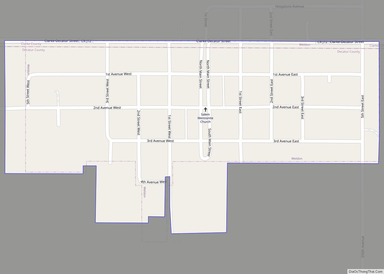
Weldon is a city in Clarke and Decatur counties of the U.S. state of Iowa. The population was 136 at the time of the 2020 census. Weldon city overview: Name: Weldon city LSAD Code: 25 LSAD Description: city (suffix) State: Iowa County: Decatur County Elevation: 1,148 ft (350 m) Total Area: 0.19 sq mi (0.50 km²) Land Area: 0.19 sq mi (0.50 km²) … Read more

Map of Webster city, Iowa

Map of Webster city, Iowa

Webster is a city in Keokuk County, Iowa, United States. The population was 94 at the time of the 2020 census. Webster city overview: Name: Webster city LSAD Code: 25 LSAD Description: city (suffix) State: Iowa County: Keokuk County Elevation: 853 ft (260 m) Total Area: 0.27 sq mi (0.71 km²) Land Area: 0.27 sq mi (0.71 km²) Water Area: 0.00 sq mi (0.00 km²) Total … Read more

Map of Wesley city

Map of Wesley city

Wesley is a city in Kossuth County, Iowa, United States. The population was 391 at the time of the 2020 census. Wesley city overview: Name: Wesley city LSAD Code: 25 LSAD Description: city (suffix) State: Iowa County: Kossuth County Elevation: 1,250 ft (381 m) Total Area: 0.67 sq mi (1.73 km²) Land Area: 0.67 sq mi (1.73 km²) Water Area: 0.00 sq mi (0.00 km²) Total … Read more

Map of Welton city

Map of Welton city

Welton is a city in Clinton County, Iowa, United States. The population was 121 at the time of the 2020 census. The community is located adjacent to U.S. Route 61, which bypasses Welton just to the east of the city. Prior to the expansion of Highway 61 to a four-lane highway, it passed directly through … Read more

Map of Wellsburg city

Map of Wellsburg city, Iowa

Wellsburg is a city in Grundy County, Iowa, United States. The population was 720 at the 2020 census, a slight increase from 716 in 2000. It is part of the Waterloo–Cedar Falls Metropolitan Statistical Area. The city is named for George Wells, an early settler in the region. Wellsburg city overview: Name: Wellsburg city LSAD … Read more

Map of West Branch city

Map of West Branch city, Iowa

West Branch is a city in Cedar and Johnson counties in the U.S. state of Iowa. The population was 2,509 as of the 2020 census. It is the birthplace of the only American president born in Iowa, Herbert Hoover. The Johnson County portion of West Branch is part of the Iowa City, Iowa Metropolitan Statistical … Read more

Map of West Bend city

Map of West Bend city, Iowa

West Bend is a city in Kossuth and Palo Alto (originally) counties in the U.S. state of Iowa. The population was 791 at the time of the 2020 census. West Bend city overview: Name: West Bend city LSAD Code: 25 LSAD Description: city (suffix) State: Iowa County: Kossuth County, Palo Alto County Elevation: 1,191 ft (363 m) … Read more

Map of West Amana CDP

Map of West Amana CDP

West Amana is an unincorporated community and census-designated place in Iowa County, Iowa, United States, and is part of the “seven villages” of the Amana Colonies. As of the 2010 census, the population of West Amana was 135. West Amana CDP overview: Name: West Amana CDP LSAD Code: 57 LSAD Description: CDP (suffix) State: Iowa … Read more

Map of West Burlington city

Map of West Burlington city

West Burlington is a city in Des Moines County, Iowa, United States, adjacent to the Mississippi River city of Burlington. The population was 2,968 at the 2010 census. It is part of the Burlington, IA–IL Micropolitan Statistical Area. West Burlington city overview: Name: West Burlington city LSAD Code: 25 LSAD Description: city (suffix) State: Iowa … Read more

Map of West Des Moines city

Map of West Des Moines city

West Des Moines is a city in Polk, Dallas, Warren, and Madison counties in the U.S. state of Iowa. A majority of the city is located in Polk County, a minority of the city is located in Dallas County, and small portions extend into Warren and Madison counties. As of the 2020 census, the city … Read more

Map of West Chester city

Map of West Chester city, Iowa

West Chester is a city in Washington County, Iowa, United States. It is part of the Iowa City, Iowa Metropolitan Statistical Area. The population was 144 at the time of the 2020 census. West Chester city overview: Name: West Chester city LSAD Code: 25 LSAD Description: city (suffix) State: Iowa County: Washington County Elevation: 774 ft … Read more

Map of West Point city, Iowa

Map of West Point city, Iowa

West Point is a city in Lee County, Iowa, United States. The population was 921 at the time of the 2020 census. It is part of the Fort Madison–Keokuk, IA-MO Micropolitan Statistical Area. West Point city overview: Name: West Point city LSAD Code: 25 LSAD Description: city (suffix) State: Iowa County: Lee County Elevation: 768 ft … Read more