Map of Mission city

Map of Mission city, Kansas

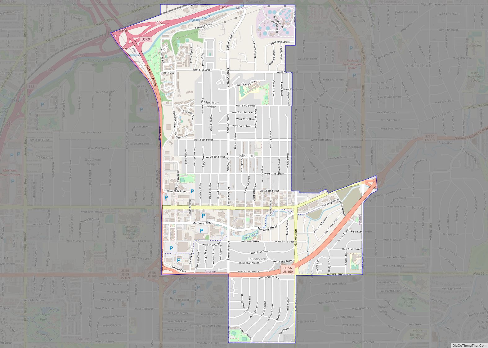
Mission is a city in Johnson County, Kansas, United States, and part of the Kansas City Metropolitan Area. As of the 2020 census, the population of the city was 9,954. Mission city overview: Name: Mission city LSAD Code: 25 LSAD Description: city (suffix) State: Kansas County: Johnson County Incorporated: 1951 Elevation: 1,024 ft (312 m) Total Area: … Read more

Map of Morland city

Map of Morland city

Morland is a city in Graham County, Kansas, United States. As of the 2020 census, the population of the city was 115. Morland city overview: Name: Morland city LSAD Code: 25 LSAD Description: city (suffix) State: Kansas County: Graham County Founded: 1884 (Fremont) Incorporated: 1906 (Morland) Elevation: 2,303 ft (702 m) Total Area: 0.48 sq mi (1.24 km²) Land Area: … Read more

Map of Morganville city

Map of Morganville city, Kansas

Morganville is a city in Clay County, Kansas, United States. As of the 2020 census, the population of the city was 180. Morganville city overview: Name: Morganville city LSAD Code: 25 LSAD Description: city (suffix) State: Kansas County: Clay County Elevation: 1,234 ft (376 m) Total Area: 0.34 sq mi (0.89 km²) Land Area: 0.34 sq mi (0.88 km²) Water Area: 0.00 sq mi (0.01 km²) … Read more

Map of Moran city

Map of Moran city, Kansas

Moran is a city in Allen County, Kansas, United States. As of the 2020 census, the population of the city was 466. Moran city overview: Name: Moran city LSAD Code: 25 LSAD Description: city (suffix) State: Kansas County: Allen County Founded: 1881 Incorporated: 1881 Elevation: 1,106 ft (337 m) Total Area: 0.42 sq mi (1.08 km²) Land Area: 0.42 sq mi (1.08 km²) … Read more

Map of Moscow city, Kansas

Map of Moscow city, Kansas

Moscow (/ˈmɒskoʊ/ MOS-koh) is a city in Stevens County, Kansas, United States. As of the 2020 census, the population of the city was 272. Moscow city overview: Name: Moscow city LSAD Code: 25 LSAD Description: city (suffix) State: Kansas County: Stevens County Founded: 1887 Incorporated: 1929 Elevation: 3,051 ft (930 m) Total Area: 0.17 sq mi (0.45 km²) Land Area: … Read more

Map of Morrowville city

Map of Morrowville city

Morrowville is a city in Washington County, Kansas, United States. As of the 2020 census, the population of the city was 114. Morrowville city overview: Name: Morrowville city LSAD Code: 25 LSAD Description: city (suffix) State: Kansas County: Washington County Founded: 1884 Incorporated: 1929 Elevation: 1,345 ft (410 m) Total Area: 0.14 sq mi (0.37 km²) Land Area: 0.14 sq mi (0.37 km²) … Read more

Map of Morrill city

Map of Morrill city, Kansas

Morrill is a city in Brown County, Kansas, United States. As of the 2020 census, the population of the city was 218. Morrill city overview: Name: Morrill city LSAD Code: 25 LSAD Description: city (suffix) State: Kansas County: Brown County Founded: 1878 Incorporated: 1886 Elevation: 1,096 ft (334 m) Total Area: 0.20 sq mi (0.51 km²) Land Area: 0.20 sq mi (0.51 km²) … Read more

Map of Moundridge city

Map of Moundridge city

Moundridge is a city in McPherson County, Kansas, United States. As of the 2020 census, the population of the city was 1,974. Manufacturing facilities for Grasshopper (lawn mowers) and Bradbury Group (roll forming equipment) are located in Moundridge. Moundridge city overview: Name: Moundridge city LSAD Code: 25 LSAD Description: city (suffix) State: Kansas County: McPherson … Read more

Map of Mound Valley city

Map of Mound Valley city

Mound Valley is a city in Labette County, Kansas, United States. As of the 2020 census, the population of the city was 348. Mound Valley city overview: Name: Mound Valley city LSAD Code: 25 LSAD Description: city (suffix) State: Kansas County: Labette County Founded: 1869 Incorporated: 1871 Elevation: 833 ft (254 m) Total Area: 0.64 sq mi (1.66 km²) Land … Read more

Map of Mound City, Kansas

Map of Mound City, Kansas

Mound City is a city in and the county seat of Linn County, Kansas, United States. As of the 2020 census, the population of the city was 647. Mound City overview: Name: Mound City LSAD Code: 25 LSAD Description: city (suffix) State: Kansas County: Linn County Founded: 1855 Incorporated: 1871 Elevation: 879 ft (268 m) Total Area: … Read more

Map of Mullinville city

Map of Mullinville city

Mullinville is a city in Kiowa County, Kansas, United States. As of the 2020 census, the population of the city was 197. Mullinville city overview: Name: Mullinville city LSAD Code: 25 LSAD Description: city (suffix) State: Kansas County: Kiowa County Founded: 1880s Incorporated: 1911 Elevation: 2,323 ft (708 m) Total Area: 0.64 sq mi (1.66 km²) Land Area: 0.64 sq mi (1.66 km²) … Read more

Map of Mulberry city, Kansas

Map of Mulberry city, Kansas

Mulberry is a city in Crawford County, Kansas, United States. As of the 2020 census, the population of the city was 409. Mulberry city overview: Name: Mulberry city LSAD Code: 25 LSAD Description: city (suffix) State: Kansas County: Crawford County Founded: 1875 Incorporated: 1902 Elevation: 909 ft (277 m) Total Area: 0.47 sq mi (1.22 km²) Land Area: 0.47 sq mi (1.22 km²) … Read more