Map of Wichita city

Map of Wichita city

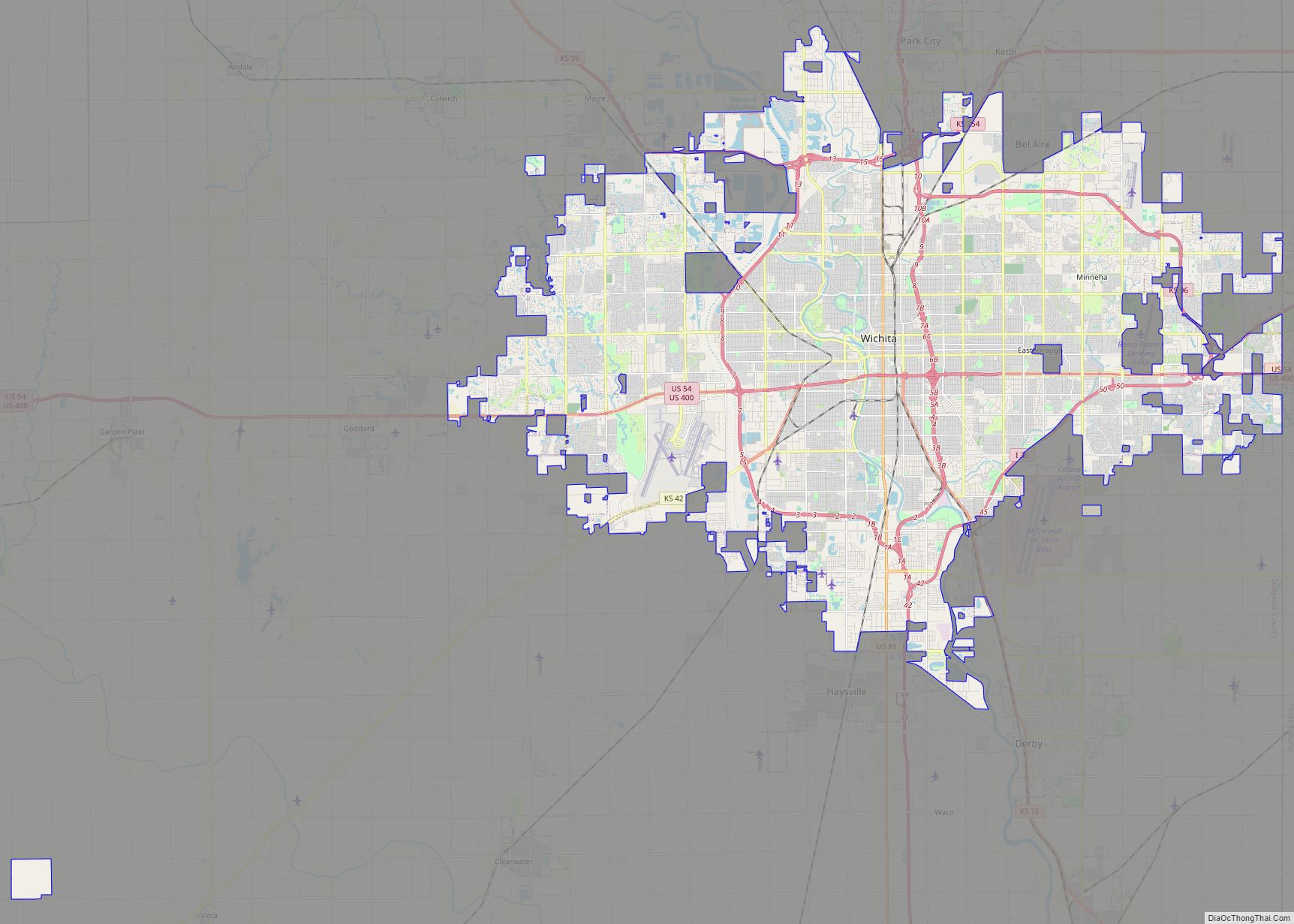
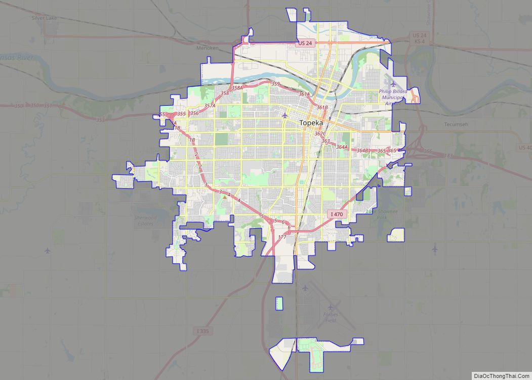
Wichita (/ˈwɪtʃɪtɑː/ WITCH-i-tah) is the largest city in the U.S. state of Kansas and the county seat of Sedgwick County. As of the 2020 census, the population of the city was 397,532. The Wichita metro area had a population of 647,610 in 2020. It is located in south-central Kansas on the Arkansas River. Wichita began … Read more

Map of Overland Park city

Map of Overland Park city

Overland Park (OH-vər-lend PARK) is a city in Johnson County, Kansas, United States, and the second-most populous city in the state of Kansas. It is one of four principal cities in the Kansas City metropolitan area and the most populous suburb of Kansas City, Missouri. As of the 2020 census, the population of the city … Read more

Map of Kansas City city

Map of Kansas City, Kansas

Kansas City (abbreviated as KCK) is the third-most populous city in the U.S. state of Kansas, and the county seat of Wyandotte County. It is an inner suburb of the older and more populous Kansas City, Missouri, after which it is named. As of the 2020 census, the population of the city was 156,607, making … Read more

Map of Olathe city, Kansas

Map of Olathe city, Kansas

Olathe (/oʊˈleɪθə/ oh-LAY-tha) is the county seat of Johnson County, Kansas, United States. It is the fourth-most populous city in both the Kansas City metropolitan area and the state of Kansas, with a 2020 population of 141,290. Olathe city overview: Name: Olathe city LSAD Code: 25 LSAD Description: city (suffix) State: Kansas County: Johnson County … Read more

Map of Topeka city, Kansas

Map of Topeka city, Kansas

Topeka (/təˈpiːkə/ tə-PEE-kə; Kansa: tó ppí kʼé; Iowa-Oto: Dópikˀe or Dópiúkˀe) is the capital city of the U.S. state of Kansas and the seat of Shawnee County. It is along the Kansas River in the central part of Shawnee County, in northeast Kansas, in the Central United States. As of the 2020 census, the population … Read more

Map of Abbyville city

Map of Abbyville city

Abbyville is a city in Reno County, Kansas, United States. As of the 2020 census, the population of the city was 83. Abbyville city overview: Name: Abbyville city LSAD Code: 25 LSAD Description: city (suffix) State: Kansas County: Reno County Founded: 1880s Incorporated: 1924 Elevation: 1,654 ft (504 m) Total Area: 0.27 sq mi (0.69 km²) Land Area: 0.27 sq mi (0.69 km²) … Read more

Map of Admire city

Map of Admire city

Admire is a city in Lyon County, Kansas, United States. As of the 2020 census, the population of the city was 130. Admire city overview: Name: Admire city LSAD Code: 25 LSAD Description: city (suffix) State: Kansas County: Lyon County Founded: 1886 Incorporated: 1916 Elevation: 1,237 ft (377 m) Total Area: 0.32 sq mi (0.84 km²) Land Area: 0.32 sq mi (0.84 km²) … Read more

Map of Ada CDP

Map of Ada CDP, Kansas

Ada is an unincorporated community in Ottawa County, Kansas, United States. As of the 2020 census, the population of the community and nearby areas was 86. It is located approximately 12 miles west of Minneapolis. Ada CDP overview: Name: Ada CDP LSAD Code: 57 LSAD Description: CDP (suffix) State: Kansas County: Ottawa County Elevation: 1,299 ft … Read more

Map of Abilene city

Map of Abilene city, Kansas

Abilene (pronounced /ˈæbɪliːn/) is a city in, and the county seat of, Dickinson County, Kansas, United States. As of the 2020 census, the population of the city was 6,460. It is home of The Dwight D. Eisenhower Presidential Library and Museum and the Greyhound Hall of Fame. Abilene city overview: Name: Abilene city LSAD Code: … Read more

Map of Albert city

Map of Albert city

Albert is a city in Barton County, Kansas, United States. As of the 2020 census, the population of the city was 132. Albert city overview: Name: Albert city LSAD Code: 25 LSAD Description: city (suffix) State: Kansas County: Barton County Founded: 1880s Incorporated: 1929 Elevation: 1,916 ft (584 m) Total Area: 0.23 sq mi (0.61 km²) Land Area: 0.23 sq mi (0.61 km²) … Read more

Map of Agra city

Map of Agra city, Kansas

Agra is a city in Phillips County, Kansas, United States. As of the 2020 census, the population of the city was 208. Agra city overview: Name: Agra city LSAD Code: 25 LSAD Description: city (suffix) State: Kansas County: Phillips County Founded: 1888 Incorporated: 1904 Elevation: 1,850 ft (560 m) Total Area: 0.25 sq mi (0.65 km²) Land Area: 0.25 sq mi (0.65 km²) … Read more

Map of Agenda city

Map of Agenda city

Agenda is a city in Republic County, Kansas, United States. As of the 2020 census, the population of the city was 47. Agenda city overview: Name: Agenda city LSAD Code: 25 LSAD Description: city (suffix) State: Kansas County: Republic County Founded: 1880s Incorporated: 1916 Elevation: 1,414 ft (431 m) Total Area: 0.17 sq mi (0.45 km²) Land Area: 0.17 sq mi (0.45 km²) … Read more