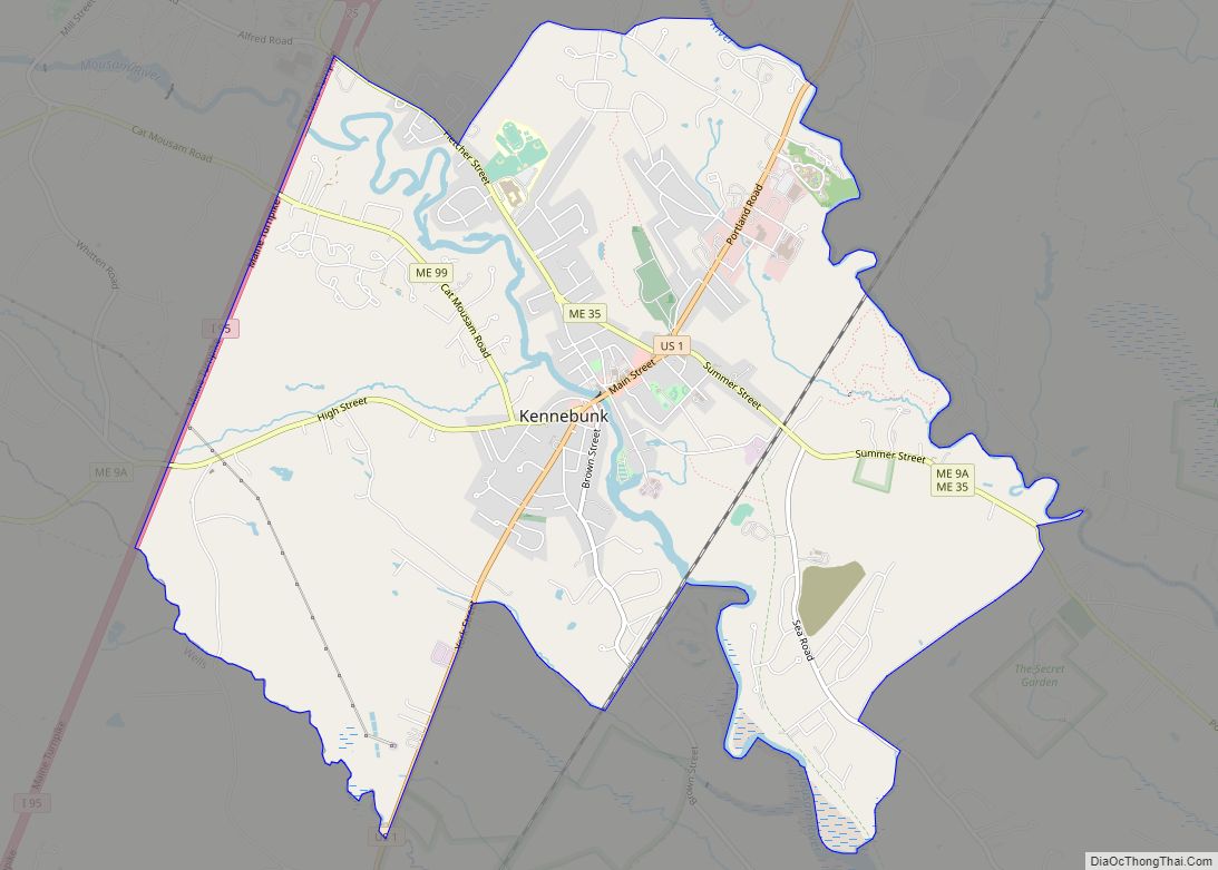
Map of Howland CDP

Map of Howland CDP

Howland is a census-designated place (CDP) in Penobscot County, Maine, United States. The population was 1,096 at the 2010 census. Howland CDP overview: Name: Howland CDP LSAD Code: 57 LSAD Description: CDP (suffix) State: Maine County: Penobscot County Elevation: 167 ft (51 m) Total Area: 7.72 sq mi (19.99 km²) Land Area: 7.46 sq mi (19.31 km²) Water Area: 0.26 sq mi (0.68 km²) Total Population: … Read more

Map of Houlton CDP

Map of Houlton CDP, Maine

Houlton is a census-designated place (CDP) comprising the main village within the town of Houlton in Aroostook County, Maine, United States. The population of the CDP was 4,856 at the 2010 census, out of a population of 6,123 for the entire town. Houlton is the county seat of Aroostook County. The northern terminus of Interstate … Read more

Map of Kittery CDP

Map of Kittery CDP

Kittery is a census-designated place (CDP) consisting of the main village in the town of Kittery in York County, Maine, United States. The village is also known as Kittery Foreside. The population of the CDP was 4,562 at the 2010 census. It is part of the Portland–South Portland–Biddeford, Maine Metropolitan Statistical Area. Kittery CDP overview: … Read more

Map of Kittery Point CDP

Map of Kittery Point CDP

Kittery Point is a census-designated place (CDP) in the town of Kittery, York County, Maine, United States. First settled in 1623, Kittery Point traces its history to the first seafarers who colonized the shore of what became Massachusetts Bay Colony and later the State of Maine. Located beside the Atlantic Ocean, it is home to … Read more

Map of Kennebunkport CDP

Map of Kennebunkport CDP

Kennebunkport is a census-designated place (CDP) consisting of the central village in the town of Kennebunkport in York County, Maine, United States. The population was 1,238 at the 2010 census, out of a total town population of 3,474. It is part of the Portland–South Portland–Biddeford, Maine Metropolitan Statistical Area. Kennebunkport CDP overview: Name: Kennebunkport CDP … Read more

Map of Lincoln CDP, Maine

Map of Lincoln CDP, Maine

Lincoln is a census-designated place (CDP) consisting of the primary settlement in the town of Lincoln in Penobscot County, Maine, United States. The population was 2,884 at the 2010 census. Lincoln CDP overview: Name: Lincoln CDP LSAD Code: 57 LSAD Description: CDP (suffix) State: Maine County: Penobscot County Elevation: 220 ft (67 m) Total Area: 8.20 sq mi (21.24 km²) … Read more

Map of Limestone CDP, Maine

Map of Limestone CDP, Maine

Limestone is a census-designated place (CDP) comprising the main village within the town of Limestone in Aroostook County, Maine, United States. The population was 1,075 at the 2010 census, out of a population of 2,314 for the entire town. Limestone CDP overview: Name: Limestone CDP LSAD Code: 57 LSAD Description: CDP (suffix) State: Maine County: … Read more

Map of Lake Arrowhead CDP, Maine

Map of Lake Arrowhead CDP, Maine

Lake Arrowhead is a census-designated place (CDP) in the towns of Waterboro and Limerick in York County, Maine, United States. The population was 3,071 at the 2010 census. The CDP corresponds to the area covered by the Lake Arrowhead Community, a large subdivision begun in the 1960s which surrounds Lake Arrowhead, an artificial lake on … Read more

Map of Littlejohn Island CDP

Map of Littlejohn Island CDP

Littlejohn Island is an island and census-designated place (CDP) in the town of Yarmouth in Cumberland County, Maine, United States. The population of the CDP was 118 at the 2010 census. It is part of the Portland–South Portland–Biddeford, Maine Metropolitan Statistical Area. The island, Cousins River and Cousins Island are named after Englishman John Cousins … Read more

Map of Little Falls CDP

Map of Little Falls CDP, Maine

Little Falls is a census-designated place (CDP) in the town of Gorham in Cumberland County, Maine, United States. The population of the CDP was 708 at the 2010 census. Prior to 2010, Little Falls was part of the Little Falls-South Windham census-designated place. It is part of the Portland–South Portland–Biddeford, Maine Metropolitan Statistical Area. Little … Read more

Map of Lisbon Falls CDP

Map of Lisbon Falls CDP

Lisbon Falls is a census-designated place (CDP) in the town of Lisbon, located in Androscoggin County, Maine, United States. The population of Lisbon Falls was 4,100 at the 2010 census. It is included in both the Lewiston–Auburn, Maine, metropolitan statistical area and the Lewiston-Auburn, Maine, Metropolitan New England city and town area. Lisbon Falls CDP … Read more

Map of Livermore Falls CDP

Map of Livermore Falls CDP

Livermore Falls is a census-designated place (CDP) in the town of Livermore Falls in Androscoggin County, Maine, United States. The population of the CDP was 1,594 at the 2010 census, out of a population of 3,187 within the full town. Livermore Falls CDP overview: Name: Livermore Falls CDP LSAD Code: 57 LSAD Description: CDP (suffix) … Read more