Map of Auburn city, Maine

Map of Auburn city, Maine

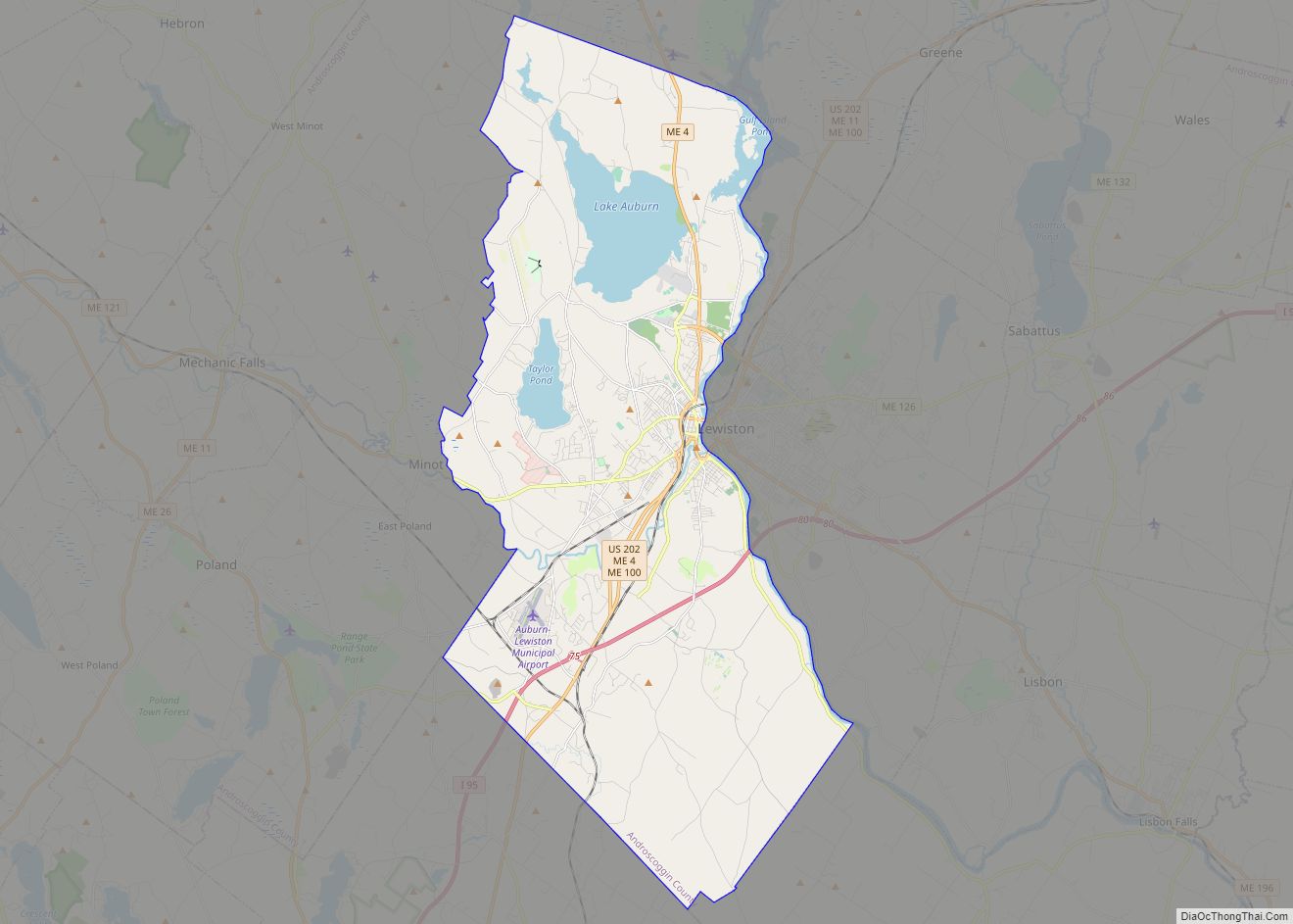
Auburn is a city in south-central Maine within the United States. The city serves as the county seat of Androscoggin County. The population was 24,061 at the 2020 census. Auburn and its sister city Lewiston are known locally as the Twin Cities or Lewiston–Auburn (L–A). Auburn city overview: Name: Auburn city LSAD Code: 25 LSAD … Read more

Map of Lewiston city, Maine

Map of Lewiston city, Maine

Lewiston (/ˈluːɪstən/; French: [luistɔ̃]; officially the City of Lewiston, Maine) is the second largest city in the U.S. state of Maine and the most central city in Androscoggin County. The city lies halfway between Augusta, the state’s capital, and Portland, the state’s most populous city. It is one-half of the Lewiston-Auburn Metropolitan Statistical Area, commonly referred … Read more

Map of Bangor city, Maine

Map of Bangor city, Maine

Bangor (/ˈbæŋɡɔːr/ BANG-gor) is a city in and the county seat of Penobscot County, Maine, United States. The city proper has a population of 31,753, making it the state’s third-largest settlement, behind Portland (68,408) and Lewiston (37,121). Bangor is known as the “Queen City.” Modern Bangor was established in the mid-19th century with the lumber … Read more

Map of Augusta city, Maine

Map of Augusta city, Maine

Augusta is the capital city of the U.S. state of Maine and the seat of Kennebec County. The city’s population was 18,899 at the 2020 census, making it the tenth-most populous city in Maine, and third-least populous state capital in the United States after Montpelier, Vermont, and Pierre, South Dakota. Located on the Kennebec River … Read more

Map of South Portland city

Map of South Portland city

South Portland is a city in Cumberland County, Maine, United States, and is the fourth-largest city in the state, incorporated in 1898. At the 2020 census, the city population was 26,498. Known for its working waterfront, South Portland is situated on Portland Harbor and overlooks the skyline of Portland and the islands of Casco Bay. … Read more

Map of Portland city, Maine

Map of Portland city, Maine

Portland (/ˈpɔːrtlənd/ PORT-lənd) is a port city and the most populous city in the U.S. state of Maine and the seat of Cumberland County. Portland’s population was 68,408 in April 2020. The Greater Portland metropolitan area is home to over half a million people, the 104th-largest metropolitan area in the United States. Portland’s economy relies … Read more

Map of Anson CDP

Map of Anson CDP, Maine

Anson is a census-designated place (CDP) in the town of Anson in Somerset County, Maine, United States. The population was 818 at the 2000 census. Anson CDP overview: Name: Anson CDP LSAD Code: 57 LSAD Description: CDP (suffix) State: Maine County: Somerset County Elevation: 240 ft (73 m) Total Area: 1.36 sq mi (3.52 km²) Land Area: 1.30 sq mi (3.36 km²) Water … Read more

Map of Alfred CDP

Map of Alfred CDP, Maine

Alfred is a town in York County, Maine, United States. As of the 2020 census, the town population was 3,073. Alfred is the seat of York County and home to part of the Massabesic Experimental Forest. National Register of Historic Places has two listings in the town, the Alfred Historic District, with 48 houses, and … Read more

Map of Bar Harbor CDP

Map of Bar Harbor CDP

Bar Harbor is a census-designated place (CDP) in the town of Bar Harbor in Hancock County, Maine, United States. The CDP population was 2,552 at the 2010 census, out of a population of 5,235 in the town of Bar Harbor as a whole. Bar Harbor CDP overview: Name: Bar Harbor CDP LSAD Code: 57 LSAD … Read more

Map of Ashland CDP, Maine

Map of Ashland CDP, Maine

Ashland is a census-designated place (CDP) comprising the main village within the town of Ashland in Aroostook County, Maine, United States. The population of the CDP was 709 at the 2010 census, out of a population of 1,309 for the entire town. Ashland CDP overview: Name: Ashland CDP LSAD Code: 57 LSAD Description: CDP (suffix) … Read more

Map of Bath city, Maine

Map of Bath city, Maine

Bath is a city in Sagadahoc County, Maine, in the United States. The population was 8,766 at the 2020 census. It is the county seat of Sagadahoc County, which includes one city and 10 towns. The city is popular with tourists, many drawn by its 19th-century architecture. It is home to the Bath Iron Works … Read more

Map of Biddeford city

Map of Biddeford city

Biddeford is a city in York County, Maine, United States. It is the principal commercial center of York County. Its population was 22,552 at the 2020 census. The twin cities of Saco and Biddeford include the resort communities of Biddeford Pool and Fortunes Rocks. The town is the site of the University of New England … Read more