Map of Newcastle CDP, Maine

Map of Newcastle CDP, Maine

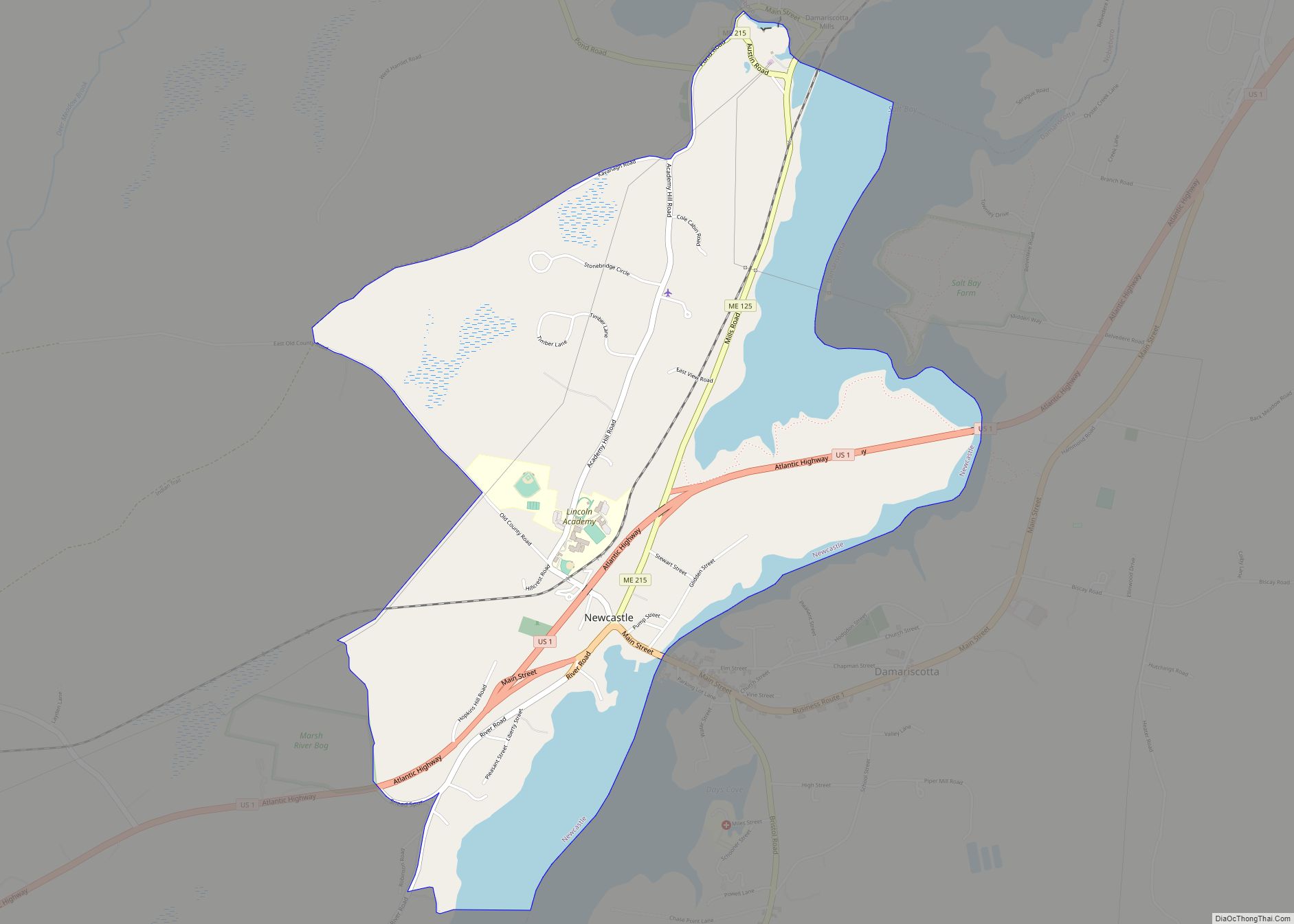
Newcastle is a census-designated place (CDP) comprising the main village of the town of Newcastle in Lincoln County, Maine, United States. The population was 667 at the 2010 census, out of 1,752 in the entire town. In the 2000 census, the village was part of the Damariscotta-Newcastle CDP. Newcastle CDP overview: Name: Newcastle CDP LSAD … Read more

Map of Naples CDP, Maine

Map of Naples CDP, Maine

Naples is a census-designated place (CDP) in the town of Naples in Cumberland County, Maine, United States. The population of the CDP was 428 at the 2010 census. It is part of the Portland–South Portland–Biddeford, Maine Metropolitan Statistical Area. Naples CDP overview: Name: Naples CDP LSAD Code: 57 LSAD Description: CDP (suffix) State: Maine County: … Read more

Map of North Windham CDP

Map of North Windham CDP

North Windham is a census-designated place (CDP) within the town of Windham in Cumberland County, Maine, United States. The population was 4,904 at the 2010 census. It is part of the Portland–South Portland–Biddeford, Maine Metropolitan Statistical Area. North Windham CDP overview: Name: North Windham CDP LSAD Code: 57 LSAD Description: CDP (suffix) State: Maine County: … Read more

Map of North Berwick CDP

Map of North Berwick CDP

North Berwick is a census-designated place (CDP) consisting of the primary settlement in the town of North Berwick in York County, Maine, United States. The population was 1,615 at the 2010 census, out of a total town population of 4,576. It is part of the Portland–South Portland–Biddeford, Maine Metropolitan Statistical Area. North Berwick CDP overview: … Read more

Map of Norridgewock CDP

Map of Norridgewock CDP

Norridgewock is a census-designated place (CDP) in the town of Norridgewock in Somerset County, Maine, United States. The population was 1,557 at the 2000 census. Norridgewock CDP overview: Name: Norridgewock CDP LSAD Code: 57 LSAD Description: CDP (suffix) State: Maine County: Somerset County Elevation: 200 ft (61 m) Total Area: 11.53 sq mi (29.87 km²) Land Area: 11.07 sq mi (28.68 km²) Water … Read more

Map of Old Orchard Beach CDP

Map of Old Orchard Beach CDP

Old Orchard Beach is a resort town and census-designated place (CDP) in York County, Maine, United States. The population was 8,960 at the 2020 census. It is part of the Portland−South Portland−Biddeford, Maine Metropolitan Statistical Area. Located on the inner side of Saco Bay on the Atlantic Ocean, the town is a popular seaside resort. … Read more

Map of Oakland CDP, Maine

Map of Oakland CDP, Maine

Oakland is a census-designated place (CDP) comprising the main population center in the town of Oakland in Kennebec County, Maine, United States. The population was 2,602 at the 2010 census, out of 6,240 in the entire town of Oakland. Oakland CDP overview: Name: Oakland CDP LSAD Code: 57 LSAD Description: CDP (suffix) State: Maine County: … Read more

Map of Norway CDP, Maine

Map of Norway CDP, Maine

Norway is a census-designated place (CDP) in the town of Norway in Oxford County, Maine, United States. The population was 2,623 at the 2000 census. Norway CDP overview: Name: Norway CDP LSAD Code: 57 LSAD Description: CDP (suffix) State: Maine County: Oxford County Elevation: 387 ft (118 m) Total Area: 5.23 sq mi (13.54 km²) Land Area: 5.05 sq mi (13.07 km²) Water … Read more

Map of Oxford CDP, Maine

Map of Oxford CDP, Maine

Oxford is a census-designated place (CDP) in the town of Oxford in Oxford County, Maine, United States. The population was 1,300 at the 2000 census. Oxford CDP overview: Name: Oxford CDP LSAD Code: 57 LSAD Description: CDP (suffix) State: Maine County: Oxford County Elevation: 328 ft (100 m) Total Area: 8.95 sq mi (23.17 km²) Land Area: 8.29 sq mi (21.47 km²) Water … Read more

Map of Orono CDP

Map of Orono CDP, Maine

Orono is a census-designated place (CDP) consisting of the eastern portion of the town of Orono in Penobscot County, Maine, United States. The population of the CDP was 9,474 at the 2010 census. Orono CDP overview: Name: Orono CDP LSAD Code: 57 LSAD Description: CDP (suffix) State: Maine County: Penobscot County Elevation: 125 ft (38 m) Total … Read more

Map of Old Town city

Map of Old Town city

Old Town is a city in Penobscot County, Maine, United States. The population was 7,431 at the 2020 census. The city’s developed area is chiefly located on the relatively large Marsh Island, but its boundaries extend beyond it. The island is surrounded and defined by the Penobscot River to the east and the Stillwater River … Read more

Map of Pittsfield CDP, Maine

Map of Pittsfield CDP, Maine

Pittsfield is a census-designated place (CDP) in the town of Pittsfield in Somerset County, Maine, United States. The population was 3,217 at the 2000 census. Pittsfield CDP overview: Name: Pittsfield CDP LSAD Code: 57 LSAD Description: CDP (suffix) State: Maine County: Somerset County Elevation: 210 ft (64 m) Total Area: 9.61 sq mi (24.88 km²) Land Area: 9.40 sq mi (24.34 km²) Water … Read more