Map of Marblehead CDP

Map of Marblehead CDP, Massachusetts

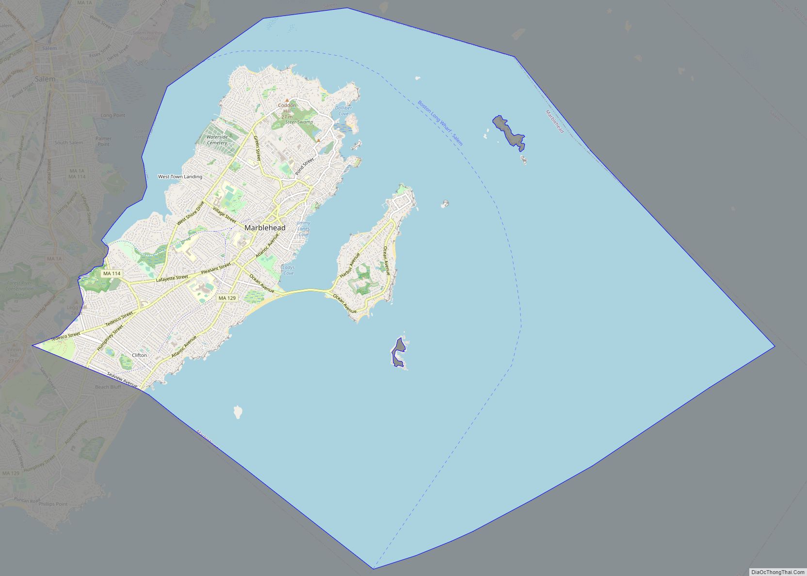
Marblehead is a coastal New England town in Essex County, Massachusetts, along the North Shore. Its population was 20,441 at the 2020 census. The town lies on a small peninsula that extends into the northern part of Massachusetts Bay. Attached to the town is a near island, known as Marblehead Neck, connected to the mainland … Read more

Map of Mansfield Center CDP, Massachusetts

Map of Mansfield Center CDP, Massachusetts

Mansfield Center is a census-designated place (CDP) in the town of Mansfield in Bristol County, Massachusetts, United States. The population was 7,360 at the 2010 census. Mansfield Center CDP overview: Name: Mansfield Center CDP LSAD Code: 57 LSAD Description: CDP (suffix) State: Massachusetts County: Bristol County Total Area: 2.82 sq mi (7.30 km²) Land Area: 2.76 sq mi (7.14 km²) Water … Read more

Map of Marlborough city

Map of Marlborough city, Massachusetts

Marlborough is a city in Middlesex County, Massachusetts, United States. The population was 41,793 at the 2020 census. Marlborough became a prosperous industrial town in the 19th century and made the transition to high technology industry in the late 20th century after the construction of the Massachusetts Turnpike. Marlborough was declared a town in 1660. … Read more

Map of Marshfield CDP

Map of Marshfield CDP, Massachusetts

Marshfield is a census-designated place (CDP) in the town of Marshfield in Plymouth County, Massachusetts, United States. The population was 4,335 at the 2010 census. Marshfield CDP overview: Name: Marshfield CDP LSAD Code: 57 LSAD Description: CDP (suffix) State: Massachusetts County: Plymouth County Elevation: 16 ft (5 m) Total Area: 5.13 sq mi (13.28 km²) Land Area: 5.05 sq mi (13.09 km²) Water … Read more

Map of Marshfield Hills CDP

Map of Marshfield Hills CDP

Marshfield Hills CDP overview: Name: Marshfield Hills CDP LSAD Code: 57 LSAD Description: CDP (suffix) State: Massachusetts County: Plymouth County FIPS code: 2538960 Online Interactive Map Marshfield Hills online map. Source: Basemap layers from Google Map, Open Street Map (OSM), Arcgisonline, Wmflabs. Boundary Data from Database of Global Administrative Areas. Marshfield Hills location map. Where … Read more

Map of Maynard CDP, Massachusetts

Map of Maynard CDP, Massachusetts

Maynard is a town in Middlesex County, Massachusetts, United States. The town is located 22 miles west of Boston, in the MetroWest and Greater Boston region of Massachusetts and borders Acton, Concord, Stow and Sudbury. The town’s population was 10,746 as of the 2020 United States Census. Maynard is located on the Assabet River, a … Read more

Map of Mattapoisett Center CDP

Map of Mattapoisett Center CDP

Mattapoisett Center is a census-designated place (CDP) in the town of Mattapoisett in Plymouth County, Massachusetts. The population was 2,915 at the 2010 census. Mattapoisett Center CDP overview: Name: Mattapoisett Center CDP LSAD Code: 57 LSAD Description: CDP (suffix) State: Massachusetts County: Plymouth County Total Area: 4.96 sq mi (12.83 km²) Land Area: 4.89 sq mi (12.67 km²) Water Area: 0.06 sq mi … Read more

Map of Mashpee Neck CDP

Map of Mashpee Neck CDP

Mashpee Neck is a census-designated place (CDP) in the town of Mashpee in Barnstable County, Massachusetts, United States. The population was 1,000 at the 2010 census. It is the most populous of the seven CDPs in Mashpee. Mashpee Neck CDP overview: Name: Mashpee Neck CDP LSAD Code: 57 LSAD Description: CDP (suffix) State: Massachusetts County: … Read more

Map of Melrose city, Massachusetts

Map of Melrose city, Massachusetts

Melrose is a city located in the Greater Boston metropolitan area in Middlesex County, Massachusetts, United States. Its population, per the 2020 United States Census, is 29,817. It is a suburb located approximately seven miles north of Boston. It is situated in the center of the triangle created by Interstates 93, 95 and U.S. Route … Read more

Map of Medford city

Map of Medford city, Massachusetts

Medford is a city 6.7 miles (10.8 km) northwest of downtown Boston on the Mystic River in Middlesex County, Massachusetts, United States. At the time of the 2020 U.S. Census, Medford’s population was 59,659. It is home to Tufts University, which has its campus along the Medford and Somerville border. Medford city overview: Name: Medford city … Read more

Map of Medfield CDP

Map of Medfield CDP

Medfield is a census-designated place (CDP) in the town of Medfield in Norfolk County, Massachusetts, United States. The population was 6,483 at the 2010 census. Medfield CDP overview: Name: Medfield CDP LSAD Code: 57 LSAD Description: CDP (suffix) State: Massachusetts County: Norfolk County Elevation: 187 ft (57 m) Total Area: 5.04 sq mi (13.05 km²) Land Area: 4.95 sq mi (12.81 km²) Water … Read more

Map of Milford CDP, Massachusetts

Map of Milford CDP, Massachusetts

Milford is a census-designated place (CDP) in the town of Milford in Worcester County, Massachusetts, United States. The population was 25,055 at the 2010 census. Milford CDP overview: Name: Milford CDP LSAD Code: 57 LSAD Description: CDP (suffix) State: Massachusetts County: Worcester County Elevation: 259 ft (79 m) Total Area: 10.39 sq mi (26.91 km²) Land Area: 10.15 sq mi (26.30 km²) Water … Read more