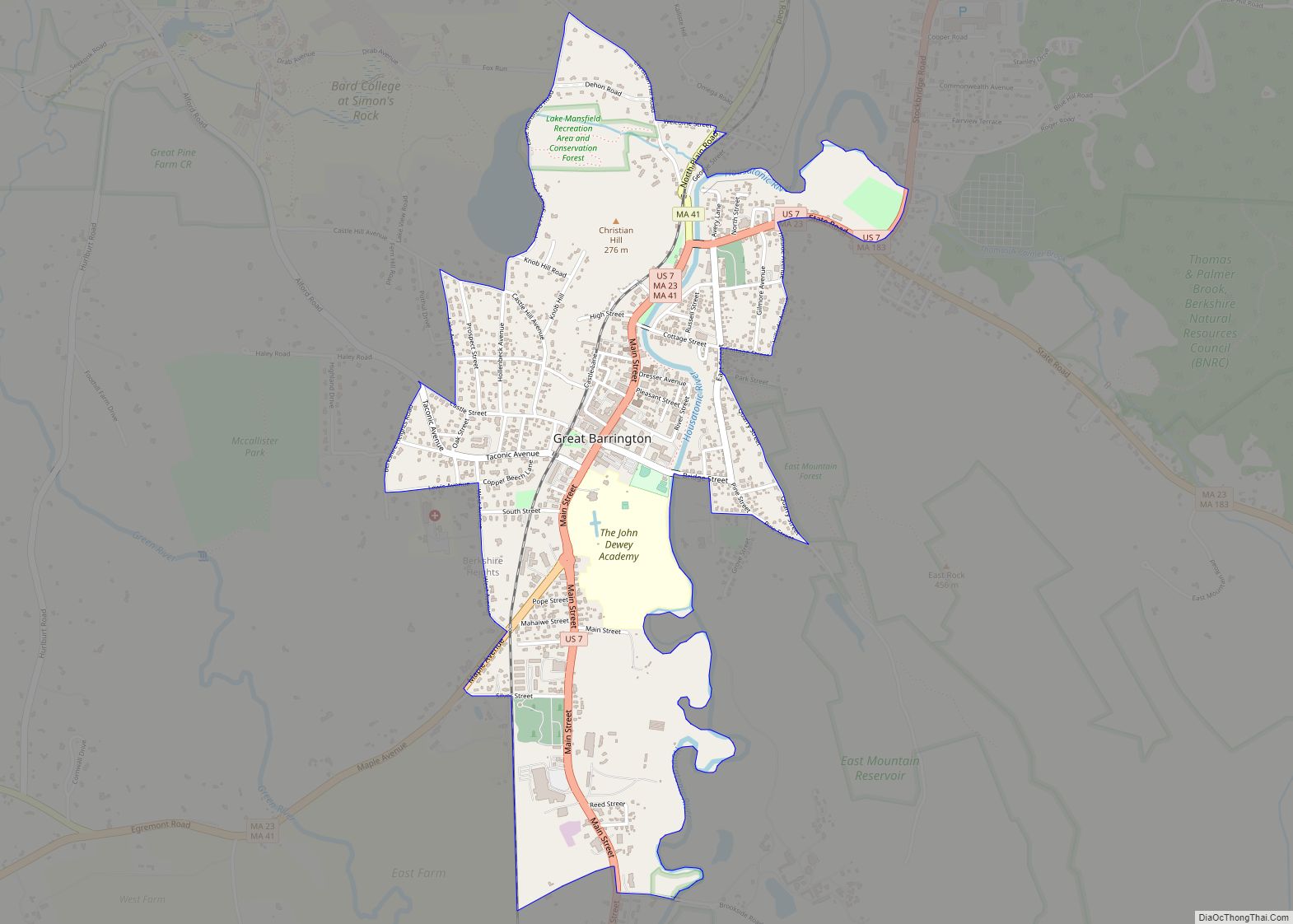
Map of Granby CDP, Massachusetts

Map of Granby CDP, Massachusetts

Granby is a census-designated place (CDP) comprising the main village in the town of Granby in Hampshire County, Massachusetts, United States. The population of the CDP was 1,368 at the 2010 census, out of a total town population of 6,240. It is part of the Springfield, Massachusetts Metropolitan Statistical Area. Granby CDP overview: Name: Granby … Read more

Map of Gloucester city

Map of Gloucester city, Massachusetts

Gloucester (/ˈɡlɒstər/) is a city in Essex County, Massachusetts, in the United States. It sits on Cape Ann and is a part of Massachusetts’s North Shore. The population was 29,729 at the 2020 U.S. Census. An important center of the fishing industry and a popular summer destination, Gloucester consists of an urban core on the … Read more

Map of Groton CDP, Massachusetts

Map of Groton CDP, Massachusetts

Groton is a census-designated place (CDP) in the town of Groton in Middlesex County, Massachusetts, United States. The population was 1,124 at the 2010 census. Groton CDP overview: Name: Groton CDP LSAD Code: 57 LSAD Description: CDP (suffix) State: Massachusetts County: Middlesex County Elevation: 331 ft (101 m) Total Area: 1.67 sq mi (4.33 km²) Land Area: 1.67 sq mi (4.33 km²) Water … Read more

Map of Greenfield Town city

Map of Greenfield Town city

Greenfield Town city overview: Name: Greenfield Town city LSAD Code: 25 LSAD Description: city (suffix) State: Massachusetts County: Franklin County FIPS code: 2527100 Online Interactive Map Greenfield Town online map. Source: Basemap layers from Google Map, Open Street Map (OSM), Arcgisonline, Wmflabs. Boundary Data from Database of Global Administrative Areas. Greenfield Town location map. Where … Read more

Map of Green Harbor-Cedar Crest CDP

Map of Green Harbor-Cedar Crest CDP

Green Harbor-Cedar Crest CDP overview: Name: Green Harbor-Cedar Crest CDP LSAD Code: 57 LSAD Description: CDP (suffix) State: Massachusetts County: Plymouth County FIPS code: 2527147 Online Interactive Map Green Harbor-Cedar Crest online map. Source: Basemap layers from Google Map, Open Street Map (OSM), Arcgisonline, Wmflabs. Boundary Data from Database of Global Administrative Areas. Green Harbor-Cedar … Read more

Map of Hanscom AFB CDP

Map of Hanscom AFB CDP

Hanscom Air Force Base (AFB) is a United States Air Force base located predominantly within Bedford, Massachusetts, with portions extending into the adjoining towns of Lincoln, Concord and Lexington. The facility is adjacent to Hanscom Field which provides general aviation and charter service. Hanscom AFB is the part of the Air Force Life Cycle Management … Read more

Map of Harwich Center CDP

Map of Harwich Center CDP

Harwich Center is a census-designated place (CDP) in the town of Harwich in Barnstable County, Massachusetts, United States. The population was 1,798 at the 2010 census. Harwich Center CDP overview: Name: Harwich Center CDP LSAD Code: 57 LSAD Description: CDP (suffix) State: Massachusetts County: Barnstable County Total Area: 2.29 sq mi (5.93 km²) Land Area: 2.25 sq mi (5.83 km²) Water … Read more

Map of Hanson CDP, Massachusetts

Map of Hanson CDP, Massachusetts

Hanson is a census-designated place (CDP) in the town of Hanson in Plymouth County, Massachusetts, United States. The population was 2,118 at the 2010 census. Hanson CDP overview: Name: Hanson CDP LSAD Code: 57 LSAD Description: CDP (suffix) State: Massachusetts County: Plymouth County Elevation: 98 ft (30 m) Total Area: 2.09 sq mi (5.42 km²) Land Area: 1.83 sq mi (4.75 km²) Water … Read more

Map of Haverhill city, Massachusetts

Map of Haverhill city, Massachusetts

Haverhill (/ˈheɪvrɪl/ HAY-vril) is a city in Essex County, Massachusetts, United States. Haverhill is located 35 miles north of Boston on the New Hampshire border and about 17 miles from the Atlantic Ocean. The population was 67,787 at the 2020 United States census. Located on the Merrimack River, Haverhill began as a farming community of … Read more

Map of Hatfield CDP, Massachusetts

Map of Hatfield CDP, Massachusetts

Hatfield is a census-designated place (CDP) comprising the main village in the town of Hatfield in Hampshire County, Massachusetts, United States. The population of the CDP was 1,318 at the 2010 census, out of a total town population of 3,279. It is part of the Springfield, Massachusetts Metropolitan Statistical Area. Hatfield CDP overview: Name: Hatfield … Read more

Map of Harwich Port CDP

Map of Harwich Port CDP

Harwich Port (also spelled Harwichport) is a small seaside community and census-designated place (CDP) situated along Nantucket Sound in the town of Harwich in Barnstable County, Massachusetts, United States. It is named after the port of Harwich in Essex, England. As of the 2010 census, the CDP had a population of 1,644. It is a … Read more

Map of Holland CDP, Massachusetts

Map of Holland CDP, Massachusetts

Holland is a census-designated place (CDP) in the town of Holland in Hampden County, Massachusetts, United States, comprising the town center and other populated areas in the eastern part of the town. The population was 1,464 at the 2010 census, out of a total 2,481 people in the town. It is part of the Springfield, … Read more