Map of Holbrook CDP, Massachusetts

Map of Holbrook CDP, Massachusetts

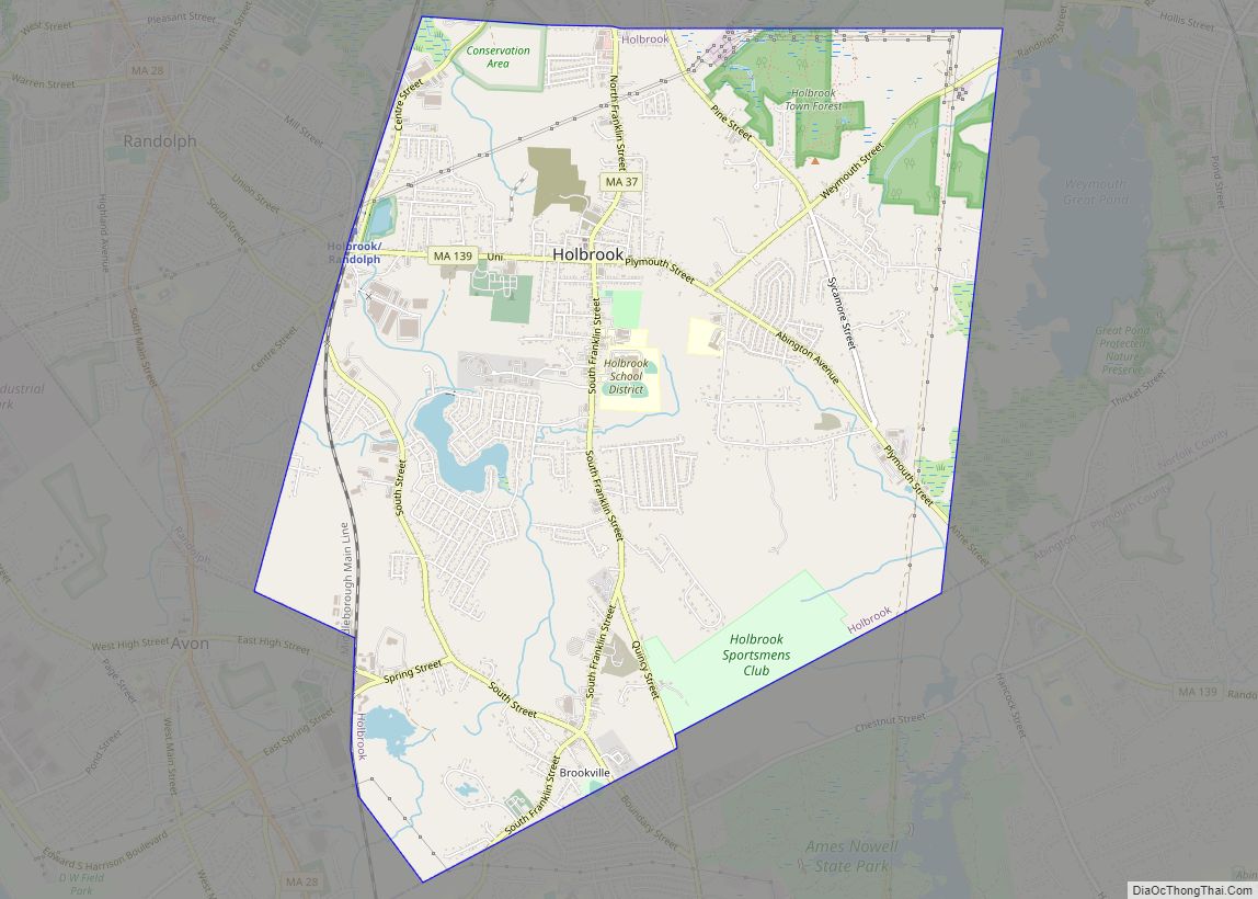
Holbrook is a town in Norfolk County, Massachusetts, United States. As of 2023, the town’s population was 12,284. Holbrook CDP overview: Name: Holbrook CDP LSAD Code: 57 LSAD Description: CDP (suffix) State: Massachusetts County: Norfolk County Incorporated: 1872 Elevation: 65 m (212 ft) Total Area: 19.2 km² (7.4 sq mi) Land Area: 19.0 km² (7.4 sq mi) Water Area: 0.1 km² (0.1 sq mi) Total Population: … Read more

Map of Hingham CDP

Map of Hingham CDP, Massachusetts

Hingham is a census-designated place (CDP) in the town of Hingham in Plymouth County, Massachusetts, United States. The population was 5,650 at the 2010 census. Hingham CDP overview: Name: Hingham CDP LSAD Code: 57 LSAD Description: CDP (suffix) State: Massachusetts County: Plymouth County Elevation: 16 ft (5 m) Total Area: 3.16 sq mi (8.18 km²) Land Area: 3.10 sq mi (8.02 km²) Water … Read more

Map of Hopkinton CDP, Massachusetts

Map of Hopkinton CDP, Massachusetts

Hopkinton is a town in Middlesex County, Massachusetts, United States, 25 miles (40 km) west of Boston. The town is best known as the starting point of the Boston Marathon, held annually on Patriots’ Day each April, and as the headquarters for the Dell EMC corporation. At the 2020 census, the town had a population of … Read more

Map of Hopedale CDP, Massachusetts

Map of Hopedale CDP, Massachusetts

Hopedale is a census-designated place (CDP) comprising the main village in the town of Hopedale, Worcester County, Massachusetts, United States. As of the 2010 census, it had a population of 3,753, out of 5,911 in the entire town of Hopedale. It is bordered to the northeast by the town of Milford and to the southwest … Read more

Map of Holyoke city, Massachusetts

Map of Holyoke city, Massachusetts

Holyoke is a city in Hampden County, Massachusetts, United States, that lies between the western bank of the Connecticut River and the Mount Tom Range. As of the 2020 census, the city had a population of 38,328. Located 8 miles (13 km) north of Springfield, Holyoke is part of the Springfield Metropolitan Area, one of the … Read more

Map of Hudson CDP, Massachusetts

Map of Hudson CDP, Massachusetts

Hudson is a census-designated place (CDP) in the town of Hudson in Middlesex County, Massachusetts, United States. The population was 14,907 at the 2010 census. Hudson CDP overview: Name: Hudson CDP LSAD Code: 57 LSAD Description: CDP (suffix) State: Massachusetts County: Middlesex County Elevation: 217 ft (66 m) Total Area: 5.92 sq mi (15.33 km²) Land Area: 5.75 sq mi (14.88 km²) Water … Read more

Map of Housatonic CDP

Map of Housatonic CDP

Housatonic is a census-designated place (CDP) in the town of Great Barrington in Berkshire County, Massachusetts. It is part of the Pittsfield, Massachusetts Metropolitan Statistical Area. The population was 1,109 at the 2010 census. It was named after the Housatonic River. Housatonic CDP overview: Name: Housatonic CDP LSAD Code: 57 LSAD Description: CDP (suffix) State: … Read more

Map of Hull CDP, Massachusetts

Map of Hull CDP, Massachusetts

Hull is a town in Plymouth County, Massachusetts, United States, located on a peninsula at the southern edge of Boston Harbor. Its population was 10,072 at the 2020 census. Hull is the smallest town by land area in Plymouth County and the eleventh smallest in the state. However, its population density is nearly four times … Read more

Map of Kingston CDP, Massachusetts

Map of Kingston CDP, Massachusetts

Kingston is a census-designated place (CDP) in the town of Kingston in Plymouth County, Massachusetts, United States. The population was 5,591 at the 2010 census. Kingston CDP overview: Name: Kingston CDP LSAD Code: 57 LSAD Description: CDP (suffix) State: Massachusetts County: Plymouth County Elevation: 59 ft (18 m) Total Area: 6.28 sq mi (16.27 km²) Land Area: 4.81 sq mi (12.46 km²) Water … Read more

Map of Ipswich CDP

Map of Ipswich CDP, Massachusetts

Ipswich is a census-designated place (CDP) located in the town of Ipswich in Essex County, Massachusetts, United States. The population was 4,222 at the 2010 census. Ipswich CDP overview: Name: Ipswich CDP LSAD Code: 57 LSAD Description: CDP (suffix) State: Massachusetts County: Essex County Elevation: 26 ft (8 m) Total Area: 1.74 sq mi (4.51 km²) Land Area: 1.64 sq mi (4.25 km²) … Read more

Map of Huntington CDP, Massachusetts

Map of Huntington CDP, Massachusetts

Huntington is a census-designated place (CDP) comprising the main village in the town of Huntington in Hampshire County, Massachusetts, United States. The population of the CDP was 936 at the 2010 census, out of a total town population of 2,180. It is part of the Springfield, Massachusetts Metropolitan Statistical Area. Huntington CDP overview: Name: Huntington … Read more

Map of Lenox CDP, Massachusetts

Map of Lenox CDP, Massachusetts

Lenox, also known as Lenox Center, is a census-designated place (CDP) in the town of Lenox in Berkshire County, Massachusetts, United States. The population was 1,675 at the 2010 census, out of 5,025 in the entire town of Lenox. Lenox CDP overview: Name: Lenox CDP LSAD Code: 57 LSAD Description: CDP (suffix) State: Massachusetts County: … Read more