Map of Crystal Springs city, Mississippi

Map of Crystal Springs city, Mississippi

Crystal Springs is a city in Copiah County, Mississippi, United States. The population was 5,044 as of the 2010 census, down from 5,873 in 2000. It is part of the Jackson Metropolitan Statistical Area. Crystal Springs city overview: Name: Crystal Springs city LSAD Code: 25 LSAD Description: city (suffix) State: Mississippi County: Copiah County Elevation: … Read more

Map of Cruger town

Map of Cruger town

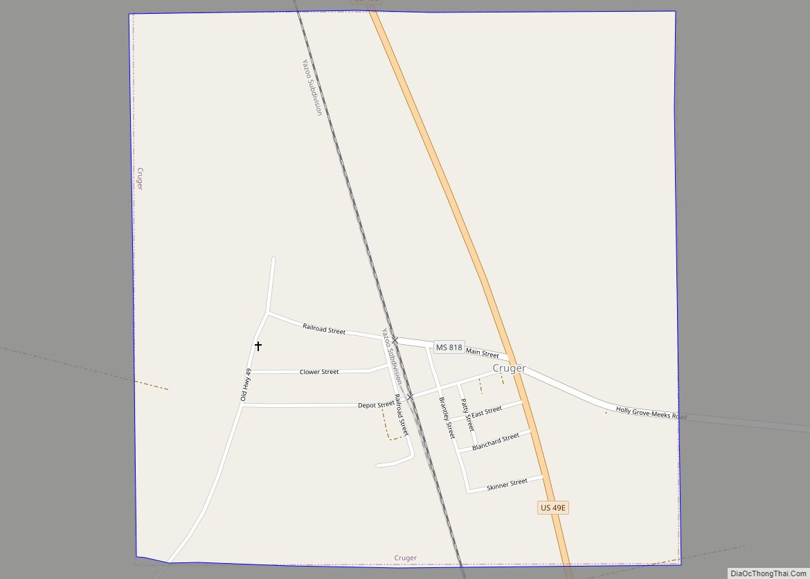
Cruger is a town in Holmes County, Mississippi, United States. Per the 2020 census, the population was 268. Cruger town overview: Name: Cruger town LSAD Code: 43 LSAD Description: town (suffix) State: Mississippi County: Holmes County Elevation: 127 ft (35 m) Total Area: 0.96 sq mi (2.50 km²) Land Area: 0.96 sq mi (2.50 km²) Water Area: 0.00 sq mi (0.00 km²) Total Population: 268 Population … Read more

Map of Derma town

Map of Derma town

Derma is a town in Calhoun County, Mississippi, United States. The population was 1,025 at the 2010 census. Derma town overview: Name: Derma town LSAD Code: 43 LSAD Description: town (suffix) State: Mississippi County: Calhoun County Elevation: 292 ft (89 m) Total Area: 1.77 sq mi (4.59 km²) Land Area: 1.77 sq mi (4.59 km²) Water Area: 0.00 sq mi (0.00 km²) Total Population: 957 Population … Read more

Map of DeLisle CDP

Map of DeLisle CDP

DeLisle (/dəˈlɪl, dəˈliːl/) is a census-designated place (CDP) in Harrison County, Mississippi, United States. It is part of the Gulfport–Biloxi Metropolitan Statistical Area. The population was 1,147 at the 2010 census. DeLisle CDP overview: Name: DeLisle CDP LSAD Code: 57 LSAD Description: CDP (suffix) State: Mississippi County: Harrison County Elevation: 23 ft (7 m) Total Area: 5.34 sq mi … Read more

Map of Decatur town, Mississippi

Map of Decatur town, Mississippi

Decatur is a town in and the county seat of Newton County, Mississippi. The population was 1,841 at the 2010 census. This town is named after war hero Stephen Decatur, Jr. Decatur town overview: Name: Decatur town LSAD Code: 43 LSAD Description: town (suffix) State: Mississippi County: Newton County Elevation: 430 ft (131 m) Total Area: 5.56 sq mi … Read more

Map of De Kalb town, Mississippi

Map of De Kalb town, Mississippi

De Kalb is a town in and the county seat of Kemper County, Mississippi, United States. The population was 1,164 at the 2010 census. De Kalb is named after General Johann de Kalb, a Franconian-French military officer who served as a major general in the Continental Army during the American Revolutionary War. De Kalb town … Read more

Map of Darling CDP

Map of Darling CDP

Darling is a census-designated place in Quitman County, Mississippi. Darling is located on Mississippi Highway 3, north of Marks. Per the 2020 Census, the population was 154. The settlement was named after Mr. Darling, a railroad official. Darling CDP overview: Name: Darling CDP LSAD Code: 57 LSAD Description: CDP (suffix) State: Mississippi County: Quitman County … Read more

Map of Dumas town, Mississippi

Map of Dumas town, Mississippi

Dumas is a town in Tippah County, Mississippi. The population was 470 at the 2010 census. Dumas town overview: Name: Dumas town LSAD Code: 43 LSAD Description: town (suffix) State: Mississippi County: Tippah County Elevation: 623 ft (190 m) Total Area: 3.89 sq mi (10.08 km²) Land Area: 3.89 sq mi (10.08 km²) Water Area: 0.00 sq mi (0.00 km²) Total Population: 471 Population Density: 120.96/sq mi … Read more

Map of Duck Hill town

Map of Duck Hill town

Duck Hill is a town in Montgomery County, Mississippi, United States. The population was 619 at the 2020 census. Duck Hill is located on U.S. Route 51, midway between Grenada and Winona. Big Bogue Creek flows east of the town. The Lucie E. Campbell Gospel and Heritage Festival takes place each summer in Duck Hill. … Read more

Map of Drew city

Map of Drew city

Drew is a city in Sunflower County, Mississippi. The population was 1,927 at the 2010 census. Drew is in the vicinity of several plantations and the Mississippi State Penitentiary, a Mississippi Department of Corrections prison for men. It is noted for several racist murders, including the lynching of Emmett Till in 1955. Drew city overview: … Read more

Map of Doddsville town

Map of Doddsville town

Doddsville is a town in Sunflower County, Mississippi. The population was 98 at the 2010 census. It was established by Daniel Doddsman Sr. in 1889. Doddsville town overview: Name: Doddsville town LSAD Code: 43 LSAD Description: town (suffix) State: Mississippi County: Sunflower County Elevation: 131 ft (40 m) Total Area: 0.77 sq mi (1.99 km²) Land Area: 0.77 sq mi (1.99 km²) Water … Read more

Map of Diamondhead city

Map of Diamondhead city

Diamondhead is a city in southeastern Hancock County, Mississippi, United States. The city is located just over 50 miles (80 km) northeast of New Orleans, Louisiana. It is part of the Gulfport−Biloxi Metropolitan Statistical Area. In February 2012, Diamondhead was officially incorporated as a city. In the 2020 USA decennial census, the city population was 9,529. … Read more