Map of Lake Tekakwitha village

Map of Lake Tekakwitha village

Lake Tekakwitha village overview: Name: Lake Tekakwitha village LSAD Code: 47 LSAD Description: village (suffix) State: Missouri County: Jefferson County FIPS code: 2940214 Online Interactive Map Lake Tekakwitha online map. Source: Basemap layers from Google Map, Open Street Map (OSM), Arcgisonline, Wmflabs. Boundary Data from Database of Global Administrative Areas. Lake Tekakwitha location map. Where … Read more

Map of Lake Tapawingo city

Map of Lake Tapawingo city

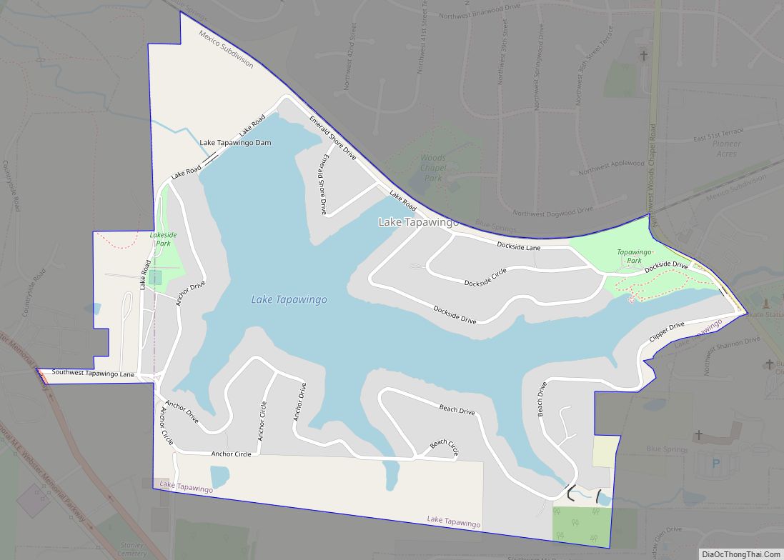
Lake Tapawingo is a city in Jackson County, Missouri, United States. The population was 730 at the 2010 census. Lake Tapawingo city overview: Name: Lake Tapawingo city LSAD Code: 25 LSAD Description: city (suffix) State: Missouri County: Jackson County Elevation: 850 ft (259 m) Total Area: 0.45 sq mi (1.17 km²) Land Area: 0.32 sq mi (0.83 km²) Water Area: 0.13 sq mi (0.34 km²) Total … Read more

Map of Lake Winnebago city

Map of Lake Winnebago city

Lake Winnebago is a city in Cass County, Missouri, United States. The population was 1,131 at the 2010 census. It is part of the Kansas City metropolitan area. Lake Winnebago city overview: Name: Lake Winnebago city LSAD Code: 25 LSAD Description: city (suffix) State: Missouri County: Cass County Elevation: 951 ft (290 m) Total Area: 2.73 sq mi (7.08 km²) … Read more

Map of Lake Waukomis city

Map of Lake Waukomis city

Lake Waukomis is a city in Platte County, Missouri and is part of the Kansas City metropolitan area within the United States. The population was 870 at the 2010 census. Lake Waukomis city overview: Name: Lake Waukomis city LSAD Code: 25 LSAD Description: city (suffix) State: Missouri County: Platte County Elevation: 938 ft (286 m) Total Area: … Read more

Map of Lakeshire city

Map of Lakeshire city

Lakeshire is a city in St. Louis County, Missouri, United States. The population was 1,432 at the 2010 census. Lakeshire city overview: Name: Lakeshire city LSAD Code: 25 LSAD Description: city (suffix) State: Missouri County: St. Louis County Elevation: 532 ft (162 m) Total Area: 0.22 sq mi (0.58 km²) Land Area: 0.22 sq mi (0.58 km²) Water Area: 0.00 sq mi (0.00 km²) Total Population: … Read more

Map of Lamar city, Missouri

Map of Lamar city, Missouri

Lamar is a city in and the county seat of Barton County, Missouri, United States. As of the 2020 census, the city population was 4,266. It is known as the birthplace of Harry S. Truman, the 33rd president of the United States. The city government is consolidated with City Township. The city of Lamar is … Read more

Map of Lamar Heights city

Map of Lamar Heights city

Lamar Heights is a city in Barton County, Missouri, United States. The population was 170 at the 2020 census. Lamar Heights city overview: Name: Lamar Heights city LSAD Code: 25 LSAD Description: city (suffix) State: Missouri County: Barton County Elevation: 955 ft (291 m) Total Area: 0.80 sq mi (2.08 km²) Land Area: 0.78 sq mi (2.03 km²) Water Area: 0.02 sq mi (0.05 km²) Total … Read more

Map of Lakeside city, Missouri

Map of Lakeside city, Missouri

Lakeside is an inactive city in Miller County, Missouri, United States, located along the Osage River near the Bagnell Dam. The population was 37 at the 2000 census. As of the 2020 census, the population was 0, with one housing unit. Lakeside city overview: Name: Lakeside city LSAD Code: 25 LSAD Description: city (suffix) State: … Read more

Map of Lancaster city, Missouri

Map of Lancaster city, Missouri

Lancaster is a city in Schuyler County, Missouri, United States. As of the 2020 census, its population was 675. It is the county seat of Schuyler County. Lancaster is part of the Kirksville Micropolitan Statistical Area. Lancaster city overview: Name: Lancaster city LSAD Code: 25 LSAD Description: city (suffix) State: Missouri County: Schuyler County Elevation: … Read more

Map of Lanagan town

Map of Lanagan town

Lanagan is a city in McDonald County, Missouri, United States. It is near Truitt’s Cave. The population was 419 at the 2010 census. Lanagan town overview: Name: Lanagan town LSAD Code: 43 LSAD Description: town (suffix) State: Missouri County: McDonald County Elevation: 869 ft (265 m) Total Area: 0.94 sq mi (2.44 km²) Land Area: 0.94 sq mi (2.44 km²) Water Area: 0.00 sq mi … Read more

Map of Lambert village

Map of Lambert village, Missouri

Lambert village overview: Name: Lambert village LSAD Code: 47 LSAD Description: village (suffix) State: Missouri County: Scott County FIPS code: 2940448 Online Interactive Map Lambert online map. Source: Basemap layers from Google Map, Open Street Map (OSM), Arcgisonline, Wmflabs. Boundary Data from Database of Global Administrative Areas. Lambert location map. Where is Lambert village? Lambert … Read more

Map of Laurie city

Map of Laurie city

Laurie is a city in southern Morgan and northern Camden counties, Missouri, United States. The population was 945 at the 2010 census. Laurie city overview: Name: Laurie city LSAD Code: 25 LSAD Description: city (suffix) State: Missouri County: Camden County, Morgan County Elevation: 883 ft (269 m) Total Area: 5.50 sq mi (14.24 km²) Land Area: 5.50 sq mi (14.24 km²) Water Area: … Read more