Map of Plymouth CDP, New Hampshire

Map of Plymouth CDP, New Hampshire

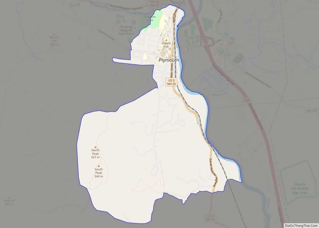
Plymouth is a census-designated place (CDP) and the main village in the town of Plymouth in Grafton County, New Hampshire, United States. Its population was 4,730 at the 2020 census, out of 6,682 in the entire town. The CDP includes the campus of Plymouth State University. Plymouth CDP overview: Name: Plymouth CDP LSAD Code: 57 … Read more

Map of Plainfield CDP, New Hampshire

Map of Plainfield CDP, New Hampshire

Plainfield is a census-designated place (CDP) and the namesake village in the town of Plainfield, Sullivan County, New Hampshire, United States. The population of the CDP was 178 at the 2020 census, out of 2,459 in the entire town. Plainfield CDP overview: Name: Plainfield CDP LSAD Code: 57 LSAD Description: CDP (suffix) State: New Hampshire … Read more

Map of Troy CDP, New Hampshire

Map of Troy CDP, New Hampshire

Troy is a census-designated place (CDP) and the main village in the town of Troy in Cheshire County, New Hampshire, United States. The population of the CDP was 1,108 at the 2020 census, compared to 2,130 in the entire town. The center of the CDP is the Troy Village Historic District. Troy CDP overview: Name: … Read more

Map of Wolfeboro CDP

Map of Wolfeboro CDP

Wolfeboro is a census-designated place (CDP) in the town of Wolfeboro in Carroll County, New Hampshire, United States. It consists of the main village of Wolfeboro within the town, as well as the smaller village of Wolfeboro Falls. The population of the CDP was 3,300 at the 2020 census, out of 6,416 in the entire … Read more

Map of Winchester CDP, New Hampshire

Map of Winchester CDP, New Hampshire

Winchester is a census-designated place (CDP) and the main village in the town of Winchester in Cheshire County, New Hampshire, United States. The population of the CDP was 1,606 at the 2020 census, compared to 4,150 in the entire town. Winchester CDP overview: Name: Winchester CDP LSAD Code: 57 LSAD Description: CDP (suffix) State: New … Read more

Map of Wilton CDP, New Hampshire

Map of Wilton CDP, New Hampshire

Wilton is a census-designated place (CDP) and the main village in the town of Wilton, Hillsborough County, New Hampshire, United States. The CDP extends east into the town of Milford as well. The population of the CDP was 1,324 at the 2020 census, up from 1,163 at the 2010 census. Wilton CDP overview: Name: Wilton … Read more

Map of Whitefield CDP

Map of Whitefield CDP, New Hampshire

Whitefield is a census-designated place (CDP) and the main village in the town of Whitefield in Coos County, New Hampshire, United States. The population of the CDP was 1,460 at the 2020 census, out of 2,490 people in the entire town of Whitefield. Whitefield CDP overview: Name: Whitefield CDP LSAD Code: 57 LSAD Description: CDP … Read more

Map of West Swanzey CDP

Map of West Swanzey CDP

West Swanzey is a census-designated place (CDP) in the town of Swanzey within Cheshire County, New Hampshire, United States. The population was 1,281 at the 2020 census. It is the largest village in the town of Swanzey. West Swanzey CDP overview: Name: West Swanzey CDP LSAD Code: 57 LSAD Description: CDP (suffix) State: New Hampshire … Read more

Map of West Stewartstown CDP

Map of West Stewartstown CDP

West Stewartstown is a census-designated place in the town of Stewartstown in Coös County, New Hampshire, United States. It had a population of 263 at the 2020 census, down from 386 at the 2010 census. West Stewartstown CDP overview: Name: West Stewartstown CDP LSAD Code: 57 LSAD Description: CDP (suffix) State: New Hampshire County: Coos … Read more

Map of Warner CDP

Map of Warner CDP, New Hampshire

Warner is a census-designated place (CDP) and the main village in the town of Warner in Merrimack County, New Hampshire, United States. The population of the CDP was 453 at the 2020 census, out of 2,937 in the entire town. Warner CDP overview: Name: Warner CDP LSAD Code: 57 LSAD Description: CDP (suffix) State: New … Read more

Map of Walpole CDP, New Hampshire

Map of Walpole CDP, New Hampshire

Walpole is a census-designated place (CDP) and the central village in the town of Walpole in Cheshire County, New Hampshire, United States. The population of the CDP was 573 at the 2020 census, compared to 3,633 in the entire town. Walpole CDP overview: Name: Walpole CDP LSAD Code: 57 LSAD Description: CDP (suffix) State: New … Read more

Map of Union CDP, New Hampshire

Map of Union CDP, New Hampshire

Union is a village and census-designated place (CDP) in the town of Wakefield, Carroll County, New Hampshire, United States. It had a population of 196 at the 2020 census. Union has a separate ZIP code (03887) from the rest of the town of Wakefield. Union CDP overview: Name: Union CDP LSAD Code: 57 LSAD Description: … Read more