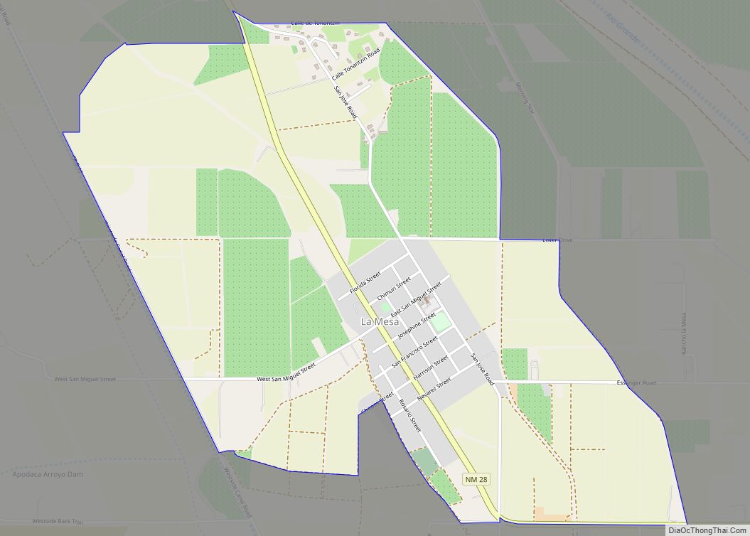
Map of La Luz CDP

Map of La Luz CDP

La Luz is a census-designated place (CDP) in Otero County, New Mexico, United States. The population was 1,615 at the 2000 census. It is located immediately north of Alamogordo and lies in the eastern edge of the Tularosa Basin and on the western flank of the Sacramento Mountains. Until 1848, La Luz was a part … Read more

Map of La Joya CDP

Map of La Joya CDP, New Mexico

La Joya is a census-designated place in Socorro County, New Mexico, United States. The community is located on the east bank of the Rio Grande, 20 miles (32 km) north of Socorro. Its population was 82 as of the 2010 census. La Joya has a post office with ZIP code 87028, which opened on February 28, … Read more

Map of La Jara CDP, New Mexico

Map of La Jara CDP, New Mexico

La Jara is a census-designated place (CDP) in Sandoval County, New Mexico, United States. The population was 209 at the 2000 census. It is part of the Albuquerque Metropolitan Statistical Area. La Jara CDP overview: Name: La Jara CDP LSAD Code: 57 LSAD Description: CDP (suffix) State: New Mexico County: Sandoval County Elevation: 7,129 ft (2,173 m) … Read more

Map of La Huerta CDP

Map of La Huerta CDP

La Huerta, formerly known as Carlsbad North, is an unincorporated area and census-designated place (CDP) in Eddy County, New Mexico, United States. The population was 1,246 at the 2010 census. The community, whose name means “fruit garden” in Spanish, was named after the orchards and garden plots that supplied food to Carlsbad. La Huerta CDP … Read more

Map of La Hacienda CDP

Map of La Hacienda CDP

La Hacienda is a census-designated place in Luna County, New Mexico, United States. Its population was 725 as of the 2010 census. Like other areas in Luna County, the community is in the Deming Public Schools school district. La Hacienda CDP overview: Name: La Hacienda CDP LSAD Code: 57 LSAD Description: CDP (suffix) State: New … Read more

Map of La Cueva CDP

Map of La Cueva CDP

La Cueva is a census-designated place in Sandoval County, New Mexico, United States. Its population was 168 as of the 2010 census. New Mexico State Road 126 passes through the community. La Cueva CDP overview: Name: La Cueva CDP LSAD Code: 57 LSAD Description: CDP (suffix) State: New Mexico County: Sandoval County Elevation: 7,680 ft (2,340 m) … Read more

Map of La Cienega CDP

Map of La Cienega CDP

La Cienega is a census-designated place (CDP) in Santa Fe County, New Mexico, United States. It is part of the Santa Fe, New Mexico, metropolitan statistical area. The population was 3,007 at the 2000 census. La Cienega is located on the site of a Keres pueblo that took part in the 1680 Pueblo Revolt. La … Read more

Map of Kirtland town

Map of Kirtland town, New Mexico

Kirtland is a town, made up of part of the former census-designated place (CDP) of the same name in San Juan County, New Mexico, United States. The population of the former CDP was 6,190 at the 2000 census. It is part of the Farmington Metropolitan Statistical Area. Kirtland town overview: Name: Kirtland town LSAD Code: … Read more

Map of La Puebla CDP

Map of La Puebla CDP

La Puebla is a census-designated place (CDP) in Santa Fe County, New Mexico, United States. It is part of the Santa Fe, New Mexico Metropolitan Statistical Area. The population was 1,296 at the 2000 census. La Puebla CDP overview: Name: La Puebla CDP LSAD Code: 57 LSAD Description: CDP (suffix) State: New Mexico County: Santa … Read more

Map of La Plata CDP, New Mexico

Map of La Plata CDP, New Mexico

La Plata is a census-designated place in San Juan County, New Mexico, United States. Its population was 612 as of the 2010 census. La Plata has a post office with ZIP code 87418. The community is located at the junction of state roads 170 and 574. La Plata CDP overview: Name: La Plata CDP LSAD … Read more

Map of La Mesilla CDP

Map of La Mesilla CDP

La Mesilla is a census-designated place in Río Arriba County, New Mexico, United States. Its population was 1,772 as of the 2010 census. In 1870, a family from La Mesilla was ambushed and killed by Mexicans disguised as Native Americans. La Mesilla CDP overview: Name: La Mesilla CDP LSAD Code: 57 LSAD Description: CDP (suffix) … Read more

Map of Lake Sumner CDP

Map of Lake Sumner CDP

Lake Sumner is a census-designated place (CDP) in De Baca County, New Mexico, United States. The population was 143 at the 2010 census, up from the figure of 86 recorded in 2000. Lake Sumner CDP overview: Name: Lake Sumner CDP LSAD Code: 57 LSAD Description: CDP (suffix) State: New Mexico County: De Baca County Elevation: … Read more