Map of Midway CDP, New Mexico

Map of Midway CDP, New Mexico

Midway is an unincorporated community and census-designated place (CDP) in Chaves County, New Mexico. The population was 971 at time of the 2010 census. Midway CDP overview: Name: Midway CDP LSAD Code: 57 LSAD Description: CDP (suffix) State: New Mexico County: Chaves County Elevation: 3,573 ft (1,089 m) Total Area: 2.49 sq mi (6.44 km²) Land Area: 2.48 sq mi (6.44 km²) Water … Read more

Map of Middle Frisco CDP

Map of Middle Frisco CDP

Middle Frisco is a census-designated place in Catron County, New Mexico, United States. Its population was 77 as of the 2010 census. The community is part of San Francisco Plaza. Middle Frisco CDP overview: Name: Middle Frisco CDP LSAD Code: 57 LSAD Description: CDP (suffix) State: New Mexico County: Catron County Elevation: 5,725 ft (1,745 m) Total … Read more

Map of Mesquite CDP

Map of Mesquite CDP, New Mexico

Mesquite is an unincorporated community and census-designated place (CDP) in Doña Ana County, New Mexico, United States. The population was 1,112 at the 2010 census, up from 948 at the 2000 census. It is part of the Las Cruces Metropolitan Statistical Area. Mesquite CDP overview: Name: Mesquite CDP LSAD Code: 57 LSAD Description: CDP (suffix) … Read more

Map of Mesita CDP

Map of Mesita CDP

Mesita is a census-designated place (CDP) in Cibola County, New Mexico, United States. The population was 804 at the 2010 census. Mesita CDP overview: Name: Mesita CDP LSAD Code: 57 LSAD Description: CDP (suffix) State: New Mexico County: Cibola County Elevation: 5,669 ft (1,728 m) Total Area: 7.49 sq mi (19.39 km²) Land Area: 7.47 sq mi (19.35 km²) Water Area: 0.01 sq mi (0.04 km²) … Read more

Map of Mesilla town

Map of Mesilla town

Mesilla (also known as La Mesilla and Old Mesilla) is a town in Doña Ana County, New Mexico, United States. The population was 2,196 at the 2010 census. It is part of the Las Cruces Metropolitan Statistical Area. During the Civil War, Mesilla briefly served as capital of the Confederate Territory of Arizona. The Mesilla … Read more

Map of Moquino CDP

Map of Moquino CDP

Moquino is a census-designated place (CDP) in Cibola County, New Mexico, United States. The population was 37 at the 2010 census. Moquino CDP overview: Name: Moquino CDP LSAD Code: 57 LSAD Description: CDP (suffix) State: New Mexico County: Cibola County Elevation: 6,120 ft (1,870 m) Total Area: 0.70 sq mi (1.81 km²) Land Area: 0.70 sq mi (1.81 km²) Water Area: 0.00 sq mi (0.00 km²) … Read more

Map of Monument CDP, New Mexico

Map of Monument CDP, New Mexico

Monument is a census-designated place and unincorporated community in Lea County, New Mexico, United States. Its population was 206 as of the 2010 census. Monument has a post office with ZIP code 88265. State routes 8 and 322 intersect in the community. It was the first inhabited community in Lea County and was named after … Read more

Map of Monterey Park CDP, New Mexico

Map of Monterey Park CDP, New Mexico

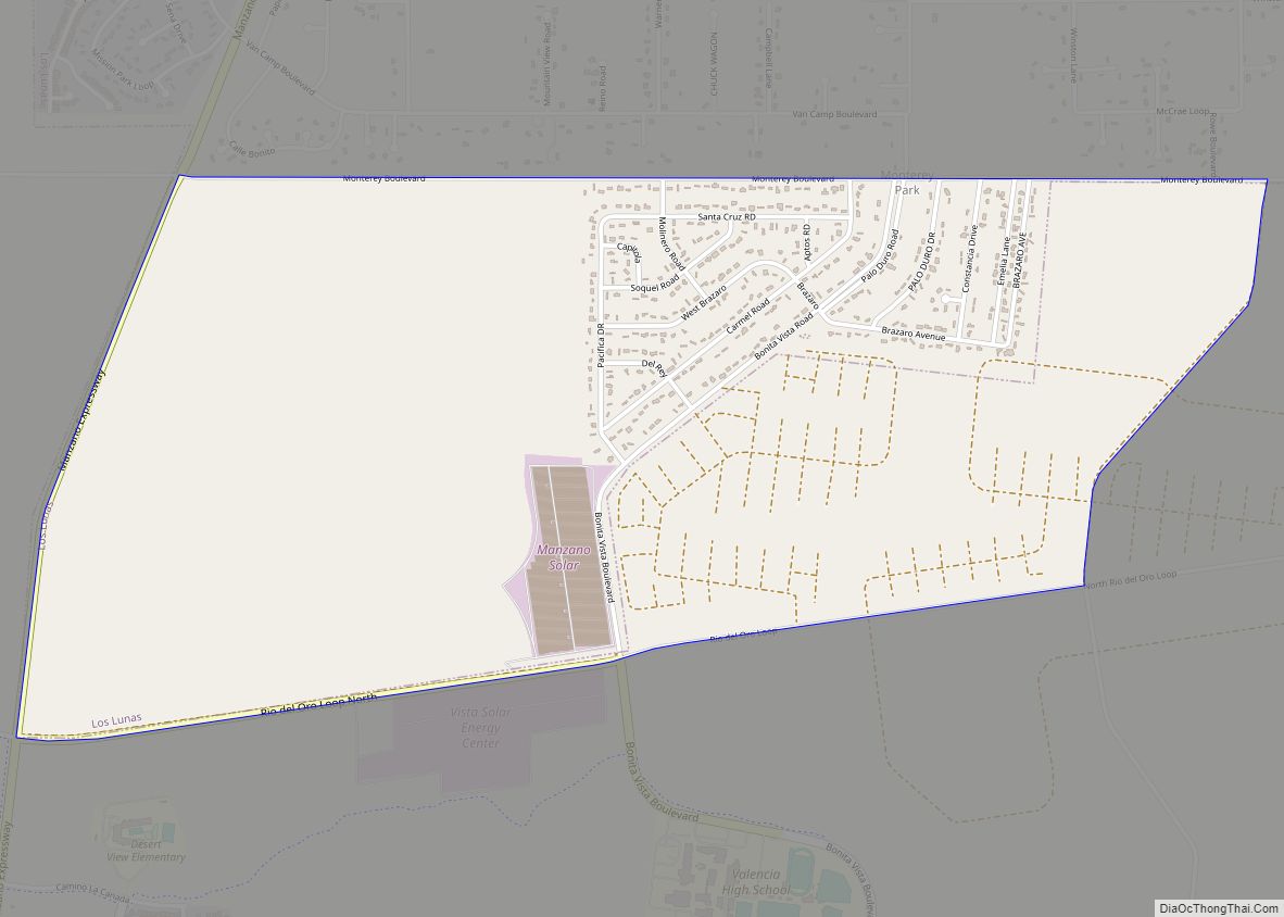
Monterey Park is a census-designated place in Valencia County, New Mexico, United States. Its population was 1,567 as of the 2010 census. It is part of the Albuquerque Metropolitan Statistical Area. The U.S. Census Bureau previously considered Monterey Park and the neighboring community of El Cerro Mission to be a single CDP, El Cerro-Monterey Park. … Read more

Map of Nambe CDP

Map of Nambe CDP

Nambé Oweenge Pueblo (/nɑːmˈbeɪ/ nahm/BAY; Tewa: Nambé Oweengé / Nąngbeʼe Ôwîngeh, IPA: [nɑ̃̀ŋbèʔ ʔówîŋɡè]) is a census-designated place (CDP) in Santa Fe County, New Mexico, and is also a federally recognized tribe of Native American Pueblo people. The Pueblo of Nambé has existed since the 14th century and is a member of the Eight Northern Pueblos. … Read more

Map of Nakaibito CDP

Map of Nakaibito CDP

Nakaibito (Navajo: Naakaii Bitoʼ) (also known as Mexican Springs) is a census-designated place (CDP) in McKinley County, New Mexico, United States. The population was 455 at the 2000 census. Nakaibito CDP overview: Name: Nakaibito CDP LSAD Code: 57 LSAD Description: CDP (suffix) State: New Mexico County: McKinley County Elevation: 6,457 ft (1,968 m) Total Area: 7.00 sq mi (18.12 km²) … Read more

Map of Nageezi CDP

Map of Nageezi CDP

Nageezi (Navajo: Naayízí) is a census-designated place (CDP) in San Juan County, New Mexico, United States. The population was 296 at the 2000 census. It is part of the Farmington Metropolitan Statistical Area. A post office was established in 1941. Nageezi’s name in Navajo means “squash.” Nageezi CDP overview: Name: Nageezi CDP LSAD Code: 57 … Read more

Map of Nadine CDP

Map of Nadine CDP

Nadine is an unincorporated community and census-designated place in Lea County, New Mexico, United States. Its population was 376 as of the 2010 census. New Mexico State Road 18 passes through the community. Nadine CDP overview: Name: Nadine CDP LSAD Code: 57 LSAD Description: CDP (suffix) State: New Mexico County: Lea County Elevation: 3,583 ft (1,092 m) … Read more