Map of Wyoming village, New York

Map of Wyoming village, New York

Wyoming is a village in Wyoming County, New York, United States. As of the 2010 census, the village has a total population of 434. The Village of Wyoming lies within the Town of Middlebury by the eastern town line. Wyoming is located on New York State Route 19. Wyoming village overview: Name: Wyoming village LSAD … Read more

Map of Wynantskill CDP

Map of Wynantskill CDP

Wynantskill is a census-designated place (CDP) in Rensselaer County, New York, United States. The population was 3,276 at the 2010 census. Wynantskill is located at the northern town line and the northeastern corner of the town of North Greenbush. The community is a suburb of Troy. state route 66 (Pawling Ave. in Troy, Main Ave. … Read more

Map of Wyandanch CDP

Map of Wyandanch CDP

Wyandanch (/ˈwaɪənˌdæntʃ/, WY-ən-danch) is a hamlet and census-designated place (CDP) in the Town of Babylon in Suffolk County, New York. The population was 12,990 at the 2020 census. In the past, some or all of Wyandanch was proposed to become part of the never-realized Incorporated Village of Half Hollow Hills and later on proposed incorporating … Read more

Map of Wurtsboro village

Map of Wurtsboro village

Wurtsboro is a village located on U.S. Route 209 in the town of Mamakating in Sullivan County, New York, United States, near its junction with New York State Route 17 (which is being upgraded to interstate standards and will be renumbered as interstate 86). The population was 1,124 at the 2020 census. Since 1927 the … Read more

Map of Worcester CDP, New York

Map of Worcester CDP, New York

Worcester is a census-designated place (CDP) forming the central settlement of the town of Worcester in Otsego County, New York, United States. The population of the CDP was 986 at the 2020 census. Worcester CDP overview: Name: Worcester CDP LSAD Code: 57 LSAD Description: CDP (suffix) State: New York County: Otsego County Elevation: 1,330 ft (410 m) … Read more

Map of Woodsville CDP, New York

Map of Woodsville CDP, New York

Woodsville is a hamlet and census-designated place (CDP) in Livingston County, New York, United States. Its population was 70 as of the 2020 census. New York State Route 36 passes through the community. Woodsville CDP overview: Name: Woodsville CDP LSAD Code: 57 LSAD Description: CDP (suffix) State: New York County: Livingston County Elevation: 646 ft (197 m) … Read more

Map of Woodstock CDP, New York

Map of Woodstock CDP, New York

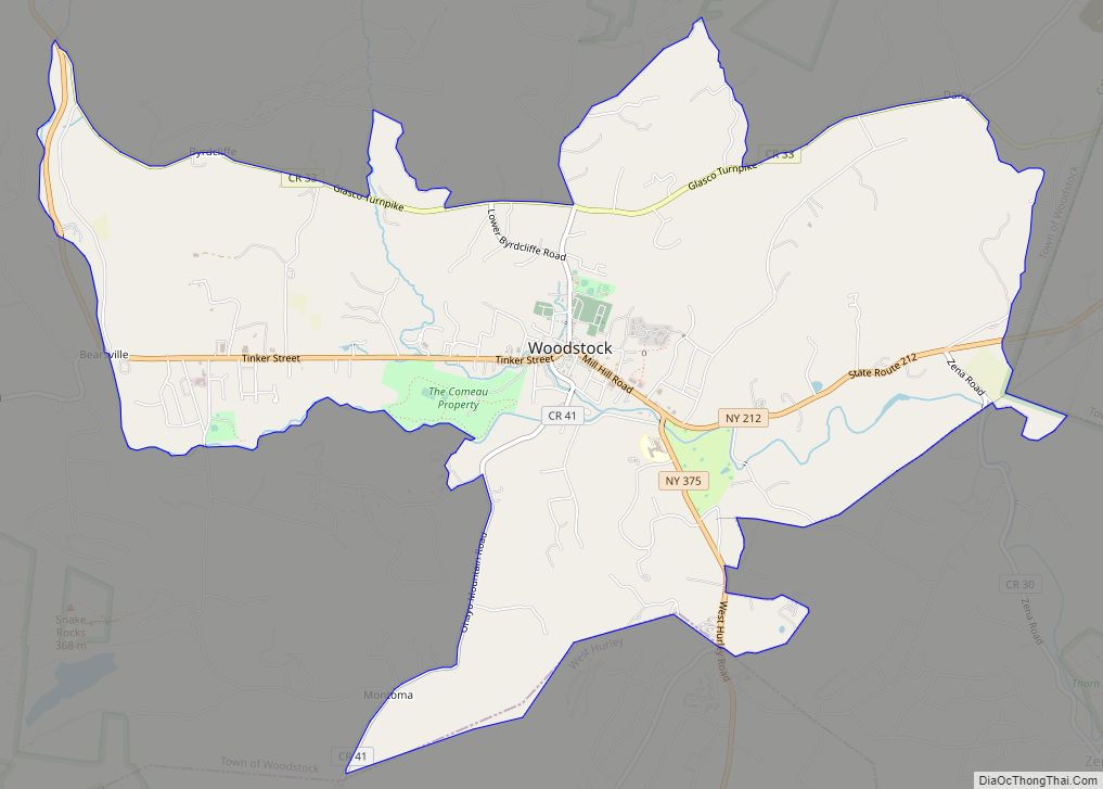
Woodstock is a hamlet (and census-designated place) in Ulster County, New York, United States. The population was 2,088 at the 2010 census. The community of Woodstock is in eastern part of the Town of Woodstock and is northwest of Kingston. It is located along NY 212 near its junction with NY 375. Although the name … Read more

Map of Yorktown Heights CDP

Map of Yorktown Heights CDP

Yorktown Heights is a census-designated place (CDP) in the town of Yorktown in Westchester County, New York, United States. The population was 1,781 at the 2010 census. Yorktown Heights CDP overview: Name: Yorktown Heights CDP LSAD Code: 57 LSAD Description: CDP (suffix) State: New York County: Westchester County Elevation: 492 ft (150 m) Total Area: 0.92 sq mi (2.39 km²) … Read more

Map of Yorkville city

Map of Yorkville village, New York

Yorkville is a village in Oneida County, New York, United States. The population was 2,689 at the 2010 census. The Village of Yorkville is in the southeastern part of the Town of Whitestown adjacent to the City of Utica. Yorkville village overview: Name: Yorkville village LSAD Code: 47 LSAD Description: village (suffix) State: New York … Read more

Map of Zena CDP

Map of Zena CDP, New York

Zena is a hamlet (and census-designated place) in Ulster County, New York, United States. As of the 2020 census the population was 1,038. Zena is in the Town of Woodstock on County Route 30. The community is northwest of Kingston. Zena is one of the more wealthy areas of this region, with the average home … Read more

Map of Youngstown village

Map of Youngstown village, New York

Youngstown is a village in Niagara County, New York, United States. The population was 1,935 at the 2010 census. It is part of the Buffalo–Niagara Falls Metropolitan Statistical Area. Youngstown is on the western edge of the town of Porter and is at the international border with Canada, at Niagara-on-the-Lake, Ontario. It is north of … Read more

Map of Yorkville village, New York

Map of Yorkville village, New York

Yorkville is a village in Oneida County, New York, United States. The population was 2,689 at the 2010 census. The Village of Yorkville is in the southeastern part of the Town of Whitestown adjacent to the City of Utica. Yorkville village overview: Name: Yorkville village LSAD Code: 47 LSAD Description: village (suffix) State: New York … Read more