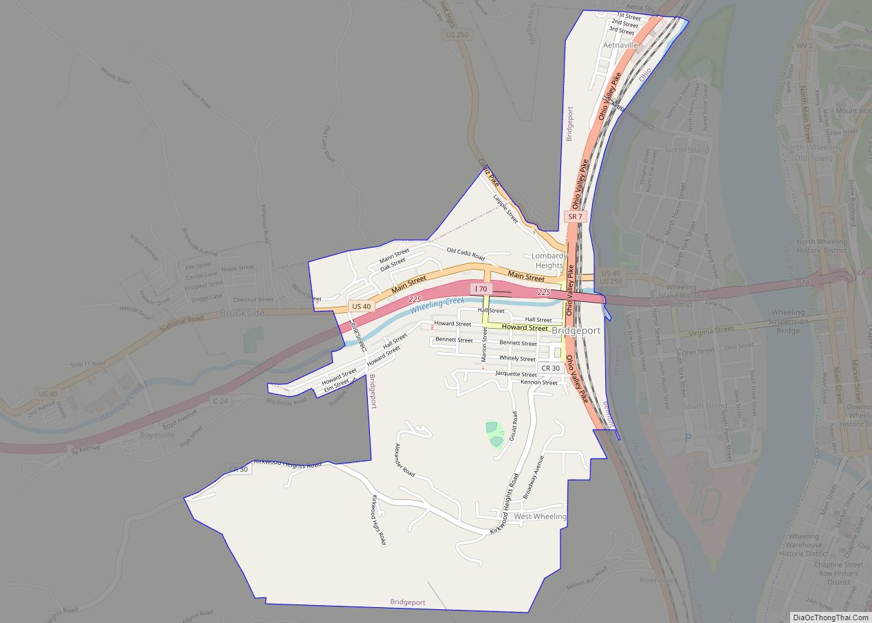
Map of Bremen village, Ohio
Bremen /ˈbrɛmən/ is a village in Fairfield County, Ohio, United States. The population was 1,425 at the 2010 census. Bremen village overview: Name: Bremen village LSAD Code: 47 LSAD Description: village (suffix) State: Ohio County: Fairfield County Elevation: 768 ft (234 m) Total Area: 0.86 sq mi (2.24 km²) Land Area: 0.86 sq mi (2.23 km²) Water Area: 0.00 sq mi (0.01 km²) Total Population: 1,479 ... Read more
Map of Bremen village, Ohio
Map of Brecon CDP
Brecon is a census-designated place (CDP) in Sycamore Township, Hamilton County, Ohio, United States. The population was 408 at the 2020 census. Brecon CDP overview: Name: Brecon CDP LSAD Code: 57 LSAD Description: CDP (suffix) State: Ohio County: Hamilton County Elevation: 870 ft (270 m) Total Area: 0.66 sq mi (1.70 km²) Land Area: 0.66 sq mi (1.70 km²) Water Area: 0.00 sq mi (0.00 km²) ... Read more
Map of Brecon CDP
Map of Brecksville city
Brecksville is a city in Cuyahoga County, Ohio, United States, and a suburb in the Greater Cleveland area. The city’s population was 13,635 at the United States 2020 Census. Brecksville city overview: Name: Brecksville city LSAD Code: 25 LSAD Description: city (suffix) State: Ohio County: Cuyahoga County Elevation: 889 ft (271 m) Total Area: 19.56 sq mi (50.66 km²) Land ... Read more
Map of Brecksville city
Map of Brookville city, Ohio
Brookville is a small city in northwestern Montgomery County, Ohio, United States. It is a suburb of Dayton. The population was 5,989 at the 2020 census. Brookville city overview: Name: Brookville city LSAD Code: 25 LSAD Description: city (suffix) State: Ohio County: Montgomery County Elevation: 1,030 ft (310 m) Total Area: 3.83 sq mi (9.92 km²) Land Area: 3.83 sq mi (9.92 km²) ... Read more
Map of Brookville city, Ohio
Map of Brookside village, Ohio
Brookside is a village in eastern Belmont County, Ohio, United States. The population was 538 at the 2020 census. It is part of the Wheeling metropolitan area. Brookside village overview: Name: Brookside village LSAD Code: 47 LSAD Description: village (suffix) State: Ohio County: Belmont County Elevation: 659 ft (201 m) Total Area: 0.18 sq mi (0.46 km²) Land Area: 0.17 sq mi ... Read more
Map of Brookside village, Ohio
Map of Brooklyn city, Ohio
Brooklyn is a city in Cuyahoga County, Ohio, United States, and a suburb of Cleveland. The population was 11,359 at the 2020 census. Brooklyn city overview: Name: Brooklyn city LSAD Code: 25 LSAD Description: city (suffix) State: Ohio County: Cuyahoga County Elevation: 764 ft (233 m) Total Area: 4.28 sq mi (11.09 km²) Land Area: 4.25 sq mi (11.01 km²) Water Area: 0.03 sq mi ... Read more
Map of Brooklyn city, Ohio
Map of Brooklyn Heights village, Ohio
Brooklyn Heights is a village in Cuyahoga County, Ohio, United States. The population was 1,543 at the 2010 census. Brooklyn Heights village overview: Name: Brooklyn Heights village LSAD Code: 47 LSAD Description: village (suffix) State: Ohio County: Cuyahoga County Elevation: 768 ft (234 m) Total Area: 1.81 sq mi (4.69 km²) Land Area: 1.79 sq mi (4.64 km²) Water Area: 0.02 sq mi (0.05 km²) Total ... Read more
Map of Brooklyn Heights village, Ohio
Map of Brookfield Center CDP
Brookfield Center, also referred to as simply Brookfield, is an unincorporated community and census-designated place in central Brookfield Township, Trumbull County, Ohio, United States. The population was 1,141 at the 2020 census. It is part of the Youngstown–Warren metropolitan area. Brookfield Center CDP overview: Name: Brookfield Center CDP LSAD Code: 57 LSAD Description: CDP (suffix) ... Read more
Map of Brookfield Center CDP
Map of Brook Park city, Ohio
Brook Park is a city in Cuyahoga County, Ohio, United States and a suburb of Cleveland. As of the 2020 Census, the city population was 18,595 . Brook Park city overview: Name: Brook Park city LSAD Code: 25 LSAD Description: city (suffix) State: Ohio County: Cuyahoga County Elevation: 797 ft (243 m) Total Area: 7.52 sq mi (19.47 km²) Land ... Read more
Map of Brook Park city, Ohio
Map of Broadview Heights city
Broadview Heights is a city in Cuyahoga County, Ohio, United States, and a suburb in the Greater Cleveland area. The city’s population was 19,936 at the 2020 census. Broadview Heights city overview: Name: Broadview Heights city LSAD Code: 25 LSAD Description: city (suffix) State: Ohio County: Cuyahoga County Elevation: 1,191 ft (363 m) Total Area: 13.06 sq mi (33.81 km²) ... Read more
Map of Broadview Heights city
Map of Brimfield CDP, Ohio
Brimfield is a census-designated place (CDP) in Portage County, Ohio, United States. As of the 2000 census, the CDP had a population of 3,248. It is located in the central part of Brimfield Township (of which it is a part), a rural area between the Ohio cities of Akron and Kent with light industry, strip-malls, ... Read more
Map of Brimfield CDP, Ohio
Map of Brownsville CDP, Ohio
Brownsville is an unincorporated community and census-designated place (CDP) in northeastern Bowling Green Township, Licking County, Ohio, United States. As of the 2010 census, it had a population of 220. It lies at the intersection of U.S. Route 40 with State Route 668. Brownsville CDP overview: Name: Brownsville CDP LSAD Code: 57 LSAD Description: CDP ... Read more
Map of Brownsville CDP, Ohio