Chagrin Falls is a village in eastern Cuyahoga County, Ohio, United States. A suburb of Cleveland, it is part of the Cleveland metropolitan area. The village was established around Chagrin Falls on the Chagrin River. As of the 2020 census, the population was 4,188. Chagrin Falls village overview: Name: Chagrin Falls village LSAD Code: 47 ... Read more
Ohio Cities and Places
Centerville, also known as Thurman, is a village in Gallia County, Ohio, United States. The population was 87 at the 2020 census. It is part of the rural Point Pleasant micropolitan area. It is located near U.S. Route 35 near the eastern terminus of State Route 279 as the highways parallel each other for about ... Read more
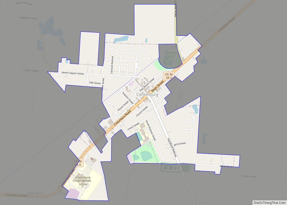
Centerburg is a village in Knox County, Ohio, United States, along the North Fork of the Licking River. As of the 2010 census, the village population was 1,773. Centerburg is the geographical center of Ohio. Centerburg village overview: Name: Centerburg village LSAD Code: 47 LSAD Description: village (suffix) State: Ohio County: Knox County Elevation: 1,220 ft ... Read more
Cheviot /ˈʃɛviət/ is a city in west-central Hamilton County, Ohio, United States. It is a suburb of Cincinnati. The population was 8,658 at the 2020 census. Cheviot city overview: Name: Cheviot city LSAD Code: 25 LSAD Description: city (suffix) State: Ohio County: Hamilton County Elevation: 909 ft (277 m) Total Area: 1.17 sq mi (3.02 km²) Land Area: 1.17 sq mi (3.02 km²) ... Read more
Chesterville is a village in Morrow County, Ohio, United States, along the Kokosing River. The population was 228 at the 2010 census. Chesterville is southeast of Mount Gilead, the county seat. Chesterville village overview: Name: Chesterville village LSAD Code: 47 LSAD Description: village (suffix) State: Ohio County: Morrow County Elevation: 1,145 ft (349 m) Total Area: 0.21 sq mi ... Read more
Chesterland is a census-designated place (CDP) in Geauga County, Ohio, United States. As of the 2020 census, the CDP had a population of 7,074. Chesterland CDP overview: Name: Chesterland CDP LSAD Code: 57 LSAD Description: CDP (suffix) State: Ohio County: Geauga County Elevation: 1,214 ft (370 m) Total Area: 14.09 sq mi (36.48 km²) Land Area: 14.02 sq mi (36.32 km²) Water Area: ... Read more
Chesterhill is a village in Morgan County, Ohio, United States. The population was 276 at the 2020 census. Chesterhill was laid out in 1834, and named after Chester County, Pennsylvania, the native home of a large share of the first settlers. Chesterhill village overview: Name: Chesterhill village LSAD Code: 47 LSAD Description: village (suffix) State: ... Read more
Cheshire /ˈtʃɛʃər/ is a village in Gallia County, Ohio, United States, along the Ohio River. The population was 123 at the 2020 census. It is part of the rural Point Pleasant micropolitan area. Cheshire village overview: Name: Cheshire village LSAD Code: 47 LSAD Description: village (suffix) State: Ohio County: Gallia County Elevation: 568 ft (173 m) Total ... Read more
Chesapeake is a village in Lawrence County, Ohio, United States. The population was 691 as of the 2020 census. It lies across the Ohio River from Huntington, West Virginia, at the mouth of Symmes Creek. A bridge across the Ohio River connects Chesapeake to Huntington’s downtown area. At one time, this was the only bridge ... Read more
Cherry Grove is a census-designated place (CDP) in Anderson Township, Hamilton County, Ohio, United States. The population was 4,419 at the 2020 census. Cherry Grove CDP overview: Name: Cherry Grove CDP LSAD Code: 57 LSAD Description: CDP (suffix) State: Ohio County: Hamilton County Elevation: 873 ft (266 m) Total Area: 1.13 sq mi (2.93 km²) Land Area: 1.13 sq mi (2.93 km²) Water ... Read more
Cherry Fork is an unincorporated community and former village in Wayne Township, Adams County, Ohio, United States. The population was 170 at the 2020 census. In 2014, voters chose to disincorporate the village. Cherry Fork CDP overview: Name: Cherry Fork CDP LSAD Code: 57 LSAD Description: CDP (suffix) State: Ohio County: Adams County Elevation: 899 ft ... Read more
Chauncey /ˈtʃænsi/ is a village in Athens County, Ohio, United States. The population was 959 at the 2020 census. The village is located near The Plains. Chauncey village overview: Name: Chauncey village LSAD Code: 47 LSAD Description: village (suffix) State: Ohio County: Athens County Elevation: 659 ft (201 m) Total Area: 0.55 sq mi (1.43 km²) Land Area: 0.55 sq mi (1.43 km²) ... Read more